Cohoe, Alaska
Cohoe is a census-designated place (CDP) in Kenai Peninsula Borough, Alaska, United States. At the 2010 census the population was 1,364,[2] up from 1,168 in 2000.
Cohoe, Alaska | |
|---|---|
 Location of Cohoe, Alaska | |
| Coordinates: 60°18′5″N 151°17′45″W | |
| Country | United States |
| State | Alaska |
| Borough | Kenai Peninsula |
| Government | |
| • Borough mayor | Mike Navarre[1] |
| • State senator | Gary Stevens (R) |
| • State rep. | Paul Seaton (R) |
| Area | |
| • Total | 73.3 sq mi (189.9 km2) |
| • Land | 69.8 sq mi (180.9 km2) |
| • Water | 3.5 sq mi (9.0 km2) |
| Elevation | 56 ft (17 m) |
| Population (2010) | |
| • Total | 1,364 |
| • Density | 19/sq mi (7.5/km2) |
| Time zone | UTC-9 (Alaska (AKST)) |
| • Summer (DST) | UTC-8 (AKDT) |
| Area code(s) | 907 |
| FIPS code | 02-16420 |
| GNIS feature ID | 1412828 |
Geography
Cohoe is located on the western side of the Kenai Peninsula at 60°18′5″N 151°17′45″W (60.301277, -151.295952).[3] It is bordered to the west by Cook Inlet, to the south by Clam Gulch and Ninilchik, to the east by the outlet of Tustumena Lake, and to the northeast by the Kasilof River and the communities of Kasilof and Kalifornsky.
Alaska Route 1 (Sterling Highway) passes through Cohoe, leading northeast 15 miles (24 km) to Soldotna and south 59 miles (95 km) to Homer.
According to the United States Census Bureau, the CDP has a total area of 73.3 square miles (189.9 km2), of which 69.8 square miles (180.9 km2) are land and 3.5 square miles (9.0 km2), or 4.73%, are water.[2]
Demographics
| Historical population | |||
|---|---|---|---|
| Census | Pop. | %± | |
| 1960 | 122 | — | |
| 1990 | 508 | — | |
| 2000 | 1,168 | 129.9% | |
| 2010 | 1,364 | 16.8% | |
| U.S. Decennial Census[4] | |||
Cohoe first appeared on the 1960 U.S. Census as an unincorporated village. It did not appear again until 1990 when it was made a census-designated place (CDP).
As of the census[5] of 2000, there were 1,168 people, 445 households, and 295 families residing in the CDP. The population density was 16.7 people per square mile (6.5/km2). There were 630 housing units at an average density of 9.0/sq mi (3.5/km2). The racial makeup of the CDP was 90.15% White, 0.26% Black or African American, 4.54% Native American, 0.60% Asian, 0.17% Pacific Islander, 0.60% from other races, and 3.68% from two or more races. 1.71% of the population were Hispanic or Latino of any race.
There were 445 households, out of which 34.6% had children under the age of 18 living with them, 56.4% were married couples living together, 5.6% had a female householder with no husband present, and 33.7% were non-families. 26.7% of all households were made up of individuals, and 6.3% had someone living alone who was 65 years of age or older. The average household size was 2.61 and the average family size was 3.20.
In the CDP, the population was spread out, with 31.3% under the age of 18, 4.5% from 18 to 24, 28.4% from 25 to 44, 28.2% from 45 to 64, and 7.7% who were 65 years of age or older. The median age was 39 years. For every 100 females, there were 117.1 males. For every 100 females age 18 and over, there were 108.0 males.
The median income for a household in the CDP was $38,542, and the median income for a family was $44,167. Males had a median income of $40,125 versus $26,154 for females. The per capita income for the CDP was $19,059. About 8.0% of families and 12.1% of the population were below the poverty line, including 9.9% of those under age 18 and 7.9% of those age 65 or over.
References
- 2015 Alaska Municipal Officials Directory. Juneau: Alaska Municipal League. 2015. p. 9.
- "Geographic Identifiers: 2010 Demographic Profile Data (G001): Cohoe CDP, Alaska". U.S. Census Bureau, American Factfinder. Retrieved January 11, 2019.
- "US Gazetteer files: 2010, 2000, and 1990". United States Census Bureau. 2011-02-12. Retrieved 2011-04-23.
- "U.S. Decennial Census". Census.gov. Retrieved June 6, 2013.
- "U.S. Census website". United States Census Bureau. Retrieved 2008-01-31.
Municipalities and communities of Kenai Peninsula Borough, Alaska, United States | ||
|---|---|---|
Borough seat: Soldotna | ||
| Cities | 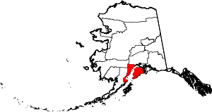 Kenai Peninsula Borough map | |
| CDPs |
| |
| Unincorporated communities | ||
| Authority control |
|
|---|