Cockatoo Valley
Cockatoo Valley is a locality in the Australian state of South Australia located about 41 kilometres (25 mi) north-east of the state capital of Adelaide and about 22 kilometres (14 mi) south-east of the municipal seat of Nuriootpa.[1][4]
| Cockatoo Valley South Australia | |||||||||||||||
|---|---|---|---|---|---|---|---|---|---|---|---|---|---|---|---|
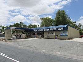 Cockatoo Valley General Store | |||||||||||||||
 Cockatoo Valley | |||||||||||||||
| Coordinates | 34°37′34″S 138°50′07″E[1] | ||||||||||||||
| Population | 700 (shared with adjoining locality) (2016 census)[2][lower-alpha 1] | ||||||||||||||
| Established | 15 May 2003 (locality)[3] | ||||||||||||||
| Postcode(s) | 5351[4] | ||||||||||||||
| Time zone | ACST (UTC+9:30) | ||||||||||||||
| • Summer (DST) | ACST (UTC+10:30) | ||||||||||||||
| Location | |||||||||||||||
| LGA(s) | Barossa Council[1] | ||||||||||||||
| Region | Barossa Light and Lower North[1] | ||||||||||||||
| County | Adelaide[1] | ||||||||||||||
| State electorate(s) | Schubert[5] | ||||||||||||||
| Federal Division(s) | Barker [6] | ||||||||||||||
| |||||||||||||||
| |||||||||||||||
| Footnotes | Locations[4][1] Adjoining localities[1] | ||||||||||||||
It was first seen and named by Europeans on 3 March 1838 when an exploration party of four young horsemen comprising John Hill, William Wood, Charles Willis, and John Oakden camped there on the first overland expedition from Adelaide to reach the River Murray at present Morgan. Oakden reported that the valley was 'swarming with cockatoos, seven of which were shot' to roast for supper.[8] They encamped there at 'a rivulet' they had discovered, later named Yettie Creek.
The 2016 Australian census which was conducted in August 2016 reports that Cockatoo Valley shared 700 people with the locality of Sandy Creek.[2]
Cockatoo Valley is located within the federal division of Barker, the state electoral district of Schubert and the local government area of the Barossa Council.[6][1][5]
References
Notes
- For the 2016 census, the State Suburb of Cockatoo Valley consisted of the locality of Cockatoo Valley and part of the adjoining locality of Sandy Creek.[1][2]
Citations
- "Search results for 'Cockatoo Valley, LOCB' with the following datasets selected - 'Suburbs and localities', 'Counties', 'Government Towns', 'Hundreds', 'Local Government Areas', 'SA Government Regions' and 'Gazetteer'". Location SA Map Viewer. South Australian Government. Retrieved 25 June 2019.
- Australian Bureau of Statistics (27 June 2017). "Cockatoo Valley (State Suburb)". 2016 Census QuickStats. Retrieved 25 June 2019.

- Weatherill, Jay (15 May 2003). "GEOGRAPHICAL NAMES ACT 1991 Notice to Assign Names and Boundaries to Places (within the Barossa Council)" (PDF). The South Australian Government Gazette. Government of South Australia. p. 1947. Retrieved 25 June 2019.
- "Postcode for Cockatoo Valley, South Australia". Postcodes Australia. Retrieved 25 June 2019.
- "Electoral District of Schubert". Electoral Commission SA. Retrieved 25 June 2019.
- "Federal electoral division of Barker". Australian Electoral Commission. Retrieved 25 June 2019.
- "Monthly climate statistics: Summary statistics ROSEDALE (TURRETFIELD RESEARCH CENTRE) (nearest weather station)". Commonwealth of Australia , Bureau of Meteorology. Retrieved 25 June 2019.
- Register newspaper, 17 March 1838, page 3