Clausthal-Zellerfeld
Clausthal-Zellerfeld is a town in Lower Saxony, Germany. It is located in the southwestern part of the Harz mountains. Its population is approximately 15,000. The City is the location of the Clausthal University of Technology. The health resort is located in the Upper Harz at an altitude between 390 and 821 m above sea level.
Clausthal-Zellerfeld | |
|---|---|
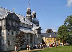 Church in 2005 | |
 Coat of arms | |
Location of Clausthal-Zellerfeld within Goslar district  | |
 Clausthal-Zellerfeld  Clausthal-Zellerfeld | |
| Coordinates: 51°48′18″N 10°20′08″E | |
| Country | Germany |
| State | Lower Saxony |
| District | Goslar |
| Subdivisions | 4 districts |
| Government | |
| • Mayor | Britta Schweigel (Ind.) |
| Area | |
| • Total | 43.71 km2 (16.88 sq mi) |
| Elevation | 560 m (1,840 ft) |
| Population (2018-12-31)[1] | |
| • Total | 15,888 |
| • Density | 360/km2 (940/sq mi) |
| Time zone | CET/CEST (UTC+1/+2) |
| Postal codes | 38678 |
| Dialling codes | 05323 |
| Vehicle registration | GS, BRL, CLZ |
| Website | www.clausthal-zellerfeld.de |
Geography
Clausthal-Zellerfeld is located on the Upper Harz Plateau. The environment is less mountainous compared to most of the Harz, but only hilly. As a result, the immediate surrounding area is less wooded and there are more meadow areas. Scattered in and around Clausthal-Zellerfeld are numerous dams and streams of the Upper Harz Water Regale.
The depression between Clausthal and Zellerfeld marks a natural "borderline".
Southwest extends the "Small Clausthal valley".
City districts
- Altenau-Schulenberg im Oberharz (since 2015)
- Buntenbock (since 1972)
- Clausthal-Zellerfeld
- Wildemann (since 2015)
History
Clausthal-Zellerfeld originally consisted of two towns which were merged in 1924 to form an administrative unit. Clausthal is well known for the old Clausthal University of Technology and its magnificent buildings, while Zellerfeld is a typical tourist resort for hikers and winter sportsmen. Clausthal-Zellerfeld is the largest town in the area that is situated in the mountains rather than on the edge.
Mining in the area began in the 16th century. Modern wire rope was invented to service the iron mines in the 1830s by the German mining engineer Wilhelm Albert in the years between 1831 and 1834 for use in mining in the Harz Mountains in Clausthal. It was quickly accepted because it proved superior to ropes made of hemp or to metal chains, such as had been used before and soon found its way into diverse applications, including most notably, suspension bridges. The Innerste Valley Railway was inaugurated in 1877 and extended to Altenau in 1914. The large station building and 70 other buildings in the town were destroyed in an air raid on 7 October 1944.[2] 92 people lost their lives.
Mining activity halted in 1930 because the ore deposits were exhausted. Today, there are large remains of mines in the surrounding Harz region, some of which are now museums. The railway line was closed in 1976. The former railway station, which was rebuilt from 1961-1963 after being destroyed in 1944, houses the tourist information and the municipal library today.
The Clausthal University of Technology was established in 1775 for the education of mining engineers. Today, it is a technical university for teaching engineering, natural science (especially chemistry, materials science and physics) and business studies.
| Historical population | ||
|---|---|---|
| Year | Pop. | ±% |
| 1821 | 11,757 | — |
| 1848 | 14,739 | +25.4% |
| 1871 | 14,080 | −4.5% |
| 1885 | 13,917 | −1.2% |
| 1905 | 13,758 | −1.1% |
| 1925 | 12,973 | −5.7% |
| 1933 | 11,855 | −8.6% |
| 1939 | 11,788 | −0.6% |
| 1946 | 15,786 | +33.9% |
| 1950 | 17,643 | +11.8% |
| 1956 | 15,585 | −11.7% |
| 1961 | 15,849 | +1.7% |
| 1968 | 16,468 | +3.9% |
| 1970 | 15,714 | −4.6% |
| 1975 | 16,690 | +6.2% |
| 1980 | 16,270 | −2.5% |
| 1985 | 16,250 | −0.1% |
| 1990 | 17,061 | +5.0% |
| 1995 | 16,703 | −2.1% |
| 2000 | 15,413 | −7.7% |
| 2005 | 15,075 | −2.2% |
| 2010 | 14,579 | −3.3% |
| 2011 | 12,798 | −12.2% |
| 2012 | 12,772 | −0.2% |
| 2013 | 12,923 | +1.2% |

Politics
Culture and sights

- Oberharzer Wasserwirschaft (Upper Harz Water Management)
Museums
- Upper Harz Mining Museum
- GeoMuseum of Clausthal University of Technology
Buildings
- Plants of Upper Harz Water Regale
- Market Church in Clausthal, the largest wooden church in Germany with 2,200 seats, built 1639-42. Tower dating from 1637.
- Old pharmacy Bergapotheke in Zellerfeld, built in 1674, with wood carvings
- Protestant Salvator Church in Zellerfeld, built 1674-83
- Clausthal mint (1617–1849)
- Oberbergamt building in Clausthal, built 1726-30
- Dietzel House in Zellerfeld, dating from 1674
- Former railway station, destroyed 1944 and rebuilt 1961-63
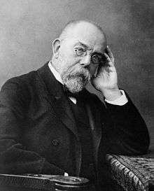
- House where Robert Koch was born
Persons
People from Clausthal-Zellerfeld

- Bernhard Christoph Breitkopf (1695-1777), printer and publisher
- Heinrich Halfeld (1797-1873), engineer
- Carl Adolf Riebeck (1821-1883), industrialist and mining entrepreneur
- Robert Koch (1843–1910), microbiologist
- Otto Erich Hartleben (1864–1905), poet and dramatist
- Robert Förster (1913-1984), diplomat
- Helmut Sander (1920-1988), mayor of Goslar
- Reinhard Roder (born 1941), football player, coach and -functionary
- Dietrich Grönemeyer (born 1952), physician
- Daniel Böhm (born 1986), biathlete
Notable people associated with Clausthal-Zellerfeld
- Georg Philipp Telemann (1681–1767), composer
- Johann Friedrich Ludwig Hausmann (1782–1859), mineralogist
- Wilhelm Albert (1787–1846), mining administrator and inventor
- Friedrich Adolph Roemer (1809–1869), geologist
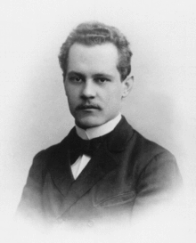
- Arnold Sommerfeld (1868–1951), theoretical physicist
- Helmut Kleinicke (1907-1979), engineer at Auschwitz concentration camp who saved Jews during the Holocaust
International relations
Gallery
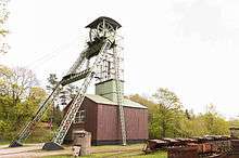 Steel headframe of Ottiliae shaft; Clausthal-Zellerfeld. This is the oldest still-existing headframe in Germany, built in 1876
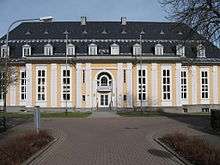 Aula Academica
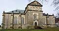 Salvatoris church
 Mining Office
 View on Marktkirche - Clausthal-Zellerfeld church in winter
References
- Landesamt für Statistik Niedersachsen, LSN-Online Regionaldatenbank, Tabelle 12411: Fortschreibung des Bevölkerungsstandes, Stand 31. Dezember 2018.
- Evert Heusinkveld. Die Innerstetalbahn Langelsheim - Altenau, p. 11. Nordhorn 2007
- "L'Aigle découverte - Nos villes jumelles". Ville de L'Aigle. Archived from the original on 2013-08-01. Retrieved 2013-07-20.
External links
| Wikimedia Commons has media related to Clausthal-Zellerfeld. |
| Wikivoyage has a travel guide for Clausthal-Zellerfeld. |
- clausthal-zellerfeld.de (in German)
- Clausthal-Zellerfeld at Curlie
- . Encyclopædia Britannica (11th ed.). 1911.
Towns and municipalities in Goslar (district) | ||
|---|---|---|
Coat of arms | ||
| Authority control |
|
|---|