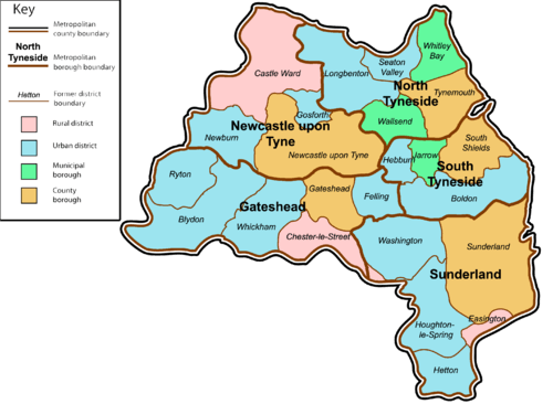
Civil parishes in Tyne and Wear
A civil parish is a country subdivision, forming the lowest unit of local government in England. There are 10 civil parishes in the ceremonial county of Tyne and Wear, most of the county being unparished; North Tyneside and South Tyneside are completely unparished. At the 2001 census, there were 41,044 people living in the 10 parishes, accounting for 3.8 per cent of the county's population.

History
Parishes arose from Church of England divisions, and were originally purely ecclesiastical divisions. Over time they acquired civil administration powers.[1]
The Highways Act 1555 made parishes responsible for the upkeep of roads. Every adult inhabitant of the parish was obliged to work four days a year on the roads, providing their own tools, carts and horses; the work was overseen by an unpaid local appointee, the Surveyor of Highways.[2]
The poor were looked after by the monasteries, until their dissolution. In 1572, magistrates were given power to 'survey the poor' and impose taxes for their relief. This system was made more formal by the Poor Law Act 1601, which made parishes responsible for administering the Poor Law; overseers were appointed to charge a rate to support the poor of the parish.[3] The 19th century saw an increase in the responsibility of parishes, although the Poor Law powers were transferred to Poor Law Unions.[4] The Public Health Act 1872 grouped parishes into Rural Sanitary Districts, based on the Poor Law Unions; these subsequently formed the basis for Rural Districts.[5]
Parishes were run by vestries, meeting annually to appoint officials, and were generally identical to ecclesiastical parishes,[6] although some townships in large parishes administered the Poor Law themselves; under the Divided Parishes and Poor Law Amendment Act 1882, all extra-parochial areas and townships that levied a separate rate became independent civil parishes.[7]
Civil parishes in their modern sense date from the Local Government Act 1894, which abolished vestries; established elected parish councils in all rural parishes with more than 300 electors; grouped rural parishes into Rural Districts; and aligned parish boundaries with county and borough boundaries.[7] Urban civil parishes continued to exist, and were generally coterminous with the Urban District, Municipal Borough or County Borough in which they were situated; many large towns contained a number of parishes, and these were usually merged into one. Parish councils were not formed in urban areas, and the only function of the parish was to elect guardians to Poor Law Unions; with the abolition of the Poor Law system in 1930 the parishes had only a nominal existence.[8]
The Local Government Act 1972 retained civil parishes in rural areas, and many former Urban Districts and Municipal Boroughs that were being abolished, were replaced by new successor parishes; urban areas that were considered too large to be single parishes became unparished areas.[9]
The current position
Recent governments have encouraged the formation of town and parish councils in unparished areas, and the Local Government and Rating Act 1997 gave local residents the right to demand the creation of a new civil parish.[10]
A parish council can become a town council unilaterally, simply by resolution;[9] and a civil parish can also gain city status, but only if that is granted by the Crown.[9] The chairman of a town or city council is called a mayor.[9] The Local Government and Public Involvement in Health Act 2007 introduced alternative names: a parish council can now choose to be called a community; village; or neighbourhood council.[11]

List of civil parishes and unparished areas


.jpg)


See also
References
- Angus Winchester, 2000, Discovering Parish Boundaries. Shire Publications. Princes Risborough, 96 pages ISBN 978-0-7478-0470-3
- RAC Foundation : What Went Wrong? British Highway Development Before Motorways Retrieved 2009-08-22
- The Victorian Web : The Poor Law : Introduction Retrieved 2009-08-22
- Staffordshire University : Poor Law Unions and Registration Districts Archived 2012-09-14 at Archive.today Retrieved 2009-08-22
- A Vision of Britain Through Time : Status Details for Rural Sanitary District Retrieved 2009-08-22
- Robert Tittler, The Reformation and the Towns in England, 1998, Oxford University Press, 395 pages, ISBN 978-0-19-820718-4
- Modern British Surnames : Selected Events in the History of Civil Registration and Boundary Changes 1801-1996 Archived August 1, 2010, at the Wayback Machine Retrieved 2009-08-22
- Alex MacMorran and T R Colquhoun Dill, The Local Government Act 1894 and the Subsequent Statutes Affecting Parish Councils, 1907, Butterworth and Co, London, 626 pages
- Office of Public Sector Information : Local Government Act 1972 Archived 2012-12-05 at Archive.today Retrieved 2009-08-22
- Office of Public Sector Information : Local Government and Rating Act 1997 Archived 2012-08-05 at Archive.today Retrieved 2009-08-22
- Office of Public Sector Information : Local Government and Public Involvement in Health Act 2007 Archived 2012-08-05 at Archive.today Retrieved 2009-08-22
- A Vision of Britain Through Time : Chester le Street Rural District Archived October 1, 2007, at the Wayback Machine Retrieved 2009-09-14
- Office for National Statistics : Census 2001 : Parish Headcounts : Gateshead Retrieved 2009-09-14
- "Birtley Town Council : Annual Return 2005/06". Archived from the original on 2006-12-13. Retrieved 2009-01-25.
- A Vision of Britain Through Time : Blaydon Urban District Retrieved 2009-09-14
- Office for National Statistics : Census 2001 : Table KS01 : Usual Resident Population Blaydon; Chopwell and Rowlands Gill; Crawcrook and Greenside (part); and Winlaton wards. Retrieved 2009-08-26
- A Vision of Britain Through Time : Felling Urban District Retrieved 2009-09-24
- Office for National Statistics : Census 2001 : Table KS01 : Usual Resident Population Felling; Leam; Pelaw and Heworth; and Wrekendyke wards. Retrieved 2009-08-26
- A Vision of Britain Through Time : Gateshead County Borough Retrieved 2009-09-14
- Office for National Statistics : Census 2001 : Table KS01 : Usual Resident Population Bede; Bensham; Chowdene; Deckham; High Fell; Lamesley (part); Low Fell; Saltwell; and Teams (part) wards. Retrieved 2009-08-26
- A Vision of Britain Through Time : Ryton Urban District Retrieved 2009-09-14
- Office for National Statistics : Census 2001 : Table KS01 : Usual Resident Population Crawcrook and Greenside (part); and Ryton wards. Retrieved 2009-08-26
- A Vision of Britain Through Time : Whickham Urban District Retrieved 2009-09-14
- Office for National Statistics : Census 2001 : Table KS01 : Usual Resident Population Dunston; Teams (part); Whickham North; and Whickham South wards. Retrieved 2009-08-26
- A Vision of Britain Through Time : Newcastle upon Tyne County Borough Retrieved 2009-09-14
- Office for National Statistics : Census 2001 : Parish Headcounts : Newcastle upon Tyne Retrieved 2009-09-14
- A Vision of Britain Through Time : Castle Ward Rural District Retrieved 2009-09-14
- A Vision of Britain Through Time : Gosforth Urban District Retrieved 2009-09-14
- Office for National Statistics : Census 2001 : Table KS01 : Usual Resident Population Grange; and South Gosforth wards. Retrieved 2009-08-26
- A Vision of Britain Through Time : Newburn Urban District Retrieved 2009-09-14
- Office for National Statistics : Census 2001 : Table KS01 : Usual Resident Population Denton; Lemington; Newburn; and Westerhope wards. Retrieved 2009-08-26
- Office for National Statistics : Census 2001 : Table KS01 : Usual Resident Population Benwell; Blakelaw (part); Byker; Castle (part); Dene; Elswick; Fawdon; Fenham; Heaton; Jesmond; Kenton; Monkchester; Moorside; Sandyford; Scotswood; West City; Walker; Walkergate; and Wingrove wards. Retrieved 2009-08-26
- A Vision of Britain Through Time : Seaton Valley Urban District Archived 2007-10-01 at the Wayback Machine Retrieved 2009-09-15
- Office for National Statistics : Census 2001 : Table KS01 : Usual Resident Population Valley ward. Retrieved 2009-08-26
- A Vision of Britain Through Time : Longbenton Urban District Retrieved 2009-09-15
- Office for National Statistics : Census 2001 : Table KS01 : Usual Resident Population Benton; Camperdown; Holystone; Longbenton; and Weetslade wards. Retrieved 2009-08-26
- A Vision of Britain Through Time : Tynemouth County Borough Retrieved 2009-09-15
- Office for National Statistics : Census 2001 : Table KS01 : Usual Resident Population Chirton; Collingwood; Cullercoats; North Shields; Riverside (part); Seatonville (part); and Tynemouth wards. Retrieved 2009-08-26
- A Vision of Britain Through Time : Wallsend Municipal Borough Retrieved 2009-09-15
- Office for National Statistics : Census 2001 : Table KS01 : Usual Resident Population Battle Hill; Howdon; Northumberland; Riverside (part); and Wallsend wards. Retrieved 2009-08-26
- A Vision of Britain Through Time : Whitley Bay Municipal Borough Retrieved 2009-09-15
- Office for National Statistics : Census 2001 : Table KS01 : Usual Resident Population Monkseaton; Seatonville (part); St Mary's; and Whitley Bay wards. Retrieved 2009-08-26
- A Vision of Britain Through Time : Boldon Urban District Retrieved 2009-09-15
- Office for National Statistics : Census 2001 : Table KS01 : Usual Resident Population Biddick Hall; Boldon Colliery; Cleadon and East Boldon; Fellgate and Hedworth; Whitburn and Marsden (part); and Whiteleas wards. Retrieved 2009-08-26
- A Vision of Britain Through Time : Hebburn Urban District Retrieved 2009-09-15
- Office for National Statistics : Census 2001 : Table KS01 : Usual Resident Population Hebburn Quay; Hebburn South; Monkton (part); and Primrose (part) wards. Retrieved 2009-08-26
- A Vision of Britain Through Time : Jarrow Municipal Borough Archived 2011-04-29 at the Wayback Machine Retrieved 2009-09-15
- Office for National Statistics : Census 2001 : Table KS01 : Usual Resident Population Bede; Monkton (part); and Primrose (part) wards. Retrieved 2009-08-26
- A Vision of Britain Through Time : South Shields County Borough Retrieved 2009-09-15
- Office for National Statistics : Census 2001 : Table KS01 : Usual Resident Population All Saints; Beacon and Bents; Cleadon Park; Harton; Horsley Hill; Rekendyke; Tyne Dock and Simonside; West Park; Westoe; and Whitburn and Marsden (part) wards. Retrieved 2009-08-26
- A Vision of Britain Through Time : Easington Rural District Retrieved 2009-09-16
- Office for National Statistics : Census 2001 : Parish Headcounts : Sunderland Retrieved 2009-09-16
- A Vision of Britain Through Time : Hetton Urban District Retrieved 2009-09-16
- A Vision of Britain Through Time : Houghton le Spring Urban District Retrieved 2009-09-15
- Office for National Statistics : Census 2001 : Table KS01 : Usual Resident Population Eppleton (part); Houghton; and Shiney Row wards. Retrieved 2009-08-26
- A Vision of Britain Through Time : Sunderland County Borough Retrieved 2009-09-15
- Office for National Statistics : Census 2001 : Table KS01 : Usual Resident Population Castletown; Central; Colliery; Fulwell; Grindon; Hendon; Pallion; Ryhope (part); Silksworth; South Hylton; Southwick; St Chad's; St Michael's; St Peter's; Thorney Close; Thornholme; and Town End Farm wards. Retrieved 2009-08-26
- A Vision of Britain Through Time : Washington Urban District Retrieved 2009-09-15
- Office for National Statistics : Census 2001 : Table KS01 : Usual Resident Population Washington East; Washington North; Washington South; and Washington West wards. Retrieved 2009-08-26