Cimarron River (Gunnison River tributary)
The Cimarron River is a 22.0-mile-long (35.4 km)[2] tributary that joins the Gunnison River in Curecanti National Recreation Area near Cimarron, Colorado. The river's source is the confluence of two forks near Silver Jack Reservoir in the Uncompahgre National Forest.
| Cimarron River[1] | |
|---|---|
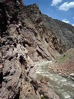 Cimarron River Gorge | |
| Physical characteristics | |
| Source | |
| ⁃ location | Confluence of East Fork and Middle Fork |
| ⁃ coordinates | 38°12′15″N 107°31′11″W |
| ⁃ elevation | 9,022 ft (2,750 m) |
| Mouth | |
⁃ location | Confluence with Gunnison River |
⁃ coordinates | 38°27′11″N 107°32′38″W |
⁃ elevation | 6,755 ft (2,059 m) |
| Basin features | |
| Progression | Gunnison—Colorado |
A Denver & Rio Grande Western narrow gauge trestle is located near the confluence of the Cimarron and the Gunnison.
References
- "Cimarron River". Geographic Names Information System. United States Geological Survey. Retrieved 2011-01-27.
- U.S. Geological Survey. National Hydrography Dataset high-resolution flowline data. The National Map Archived 2016-06-30 at the Wayback Machine, accessed March 18, 2011
This article is issued from Wikipedia. The text is licensed under Creative Commons - Attribution - Sharealike. Additional terms may apply for the media files.