Chott el Djerid
Chott el Djerid (Arabic: شط الجريد Šoṭṭ el-Jarīd) also spelled Sciott Gerid and Shott el Jerid,[2][3][4][5] is a large endorheic salt lake in southern Tunisia. The name can be translated from the Arabic into English as "Lagoon of the Land of Palms".[6]
| Chott el Djerid | |
|---|---|
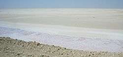 | |
 Chott el Djerid Chott al-Djarid in Tunisia | |
| Coordinates | 33.7°N 8.43°E |
| Type | Salt lake, endorheic basin |
| Primary inflows | groundwater |
| Primary outflows | terminal Evaporation |
| Basin countries | Tunisia |
| Max. length | 250 km (160 mi) |
| Max. width | 20 km (12 mi) |
| Surface area | 7,000 km2 (2,700 sq mi) |
| Surface elevation | +10–25 m (33–82 ft) |
| Designated | 7 November 2007 |
| Reference no. | 1699[1] |
Geography
The bottom of Chott el Djerid is located between 10 and 25 meters (about 30 to 80 feet) below sea level.[7] The lake's width varies widely; at its narrowest point, it is only 20 km (12 mi) across, compared to its overall length of 250 km (160 mi). At times, parts of it appear in various shades of white, green and purple.[8] The narrow eastward inlet of the chott is also known as Chott el Fejej.
It is the largest salt pan of the Sahara Desert, with a surface area of over 7,000 km2 (some sources state 5,000 km2). The site has a typical hot desert climate. Due to the harsh climate with mean annual rainfall of below 100 mm and daytime temperatures sometimes reaching 50 °C (122 °F) or more during summer with dense solar radiation, water evaporates from the lake. In summer Chott el Djerid is almost entirely dried up, and numerous fata morganas occur. Situated at 33 ° 42'N 8 ° 26'E in the center-west of the country, between the cities of Tozeur and Kebili.
During winter, a small tributary of water can be seen discharging into the lake.[9]
Because the flooded area is very variable, values presented for the area of the lake (or its basin, which is almost always dry), can vary widely. Some sources provide values as high as 10,000 km². Similarly, figures given for altitude vary between 10 meters above and 25 meters below sea level.
Currently, freshwater irrigation schemes are being applied in the region to help eliminate salt from soils and increase the productive area.
Surrounding area
South of Chott el Djerid, the Grand Erg Oriental desert begins. The towns of Kebili and Douz are also located south of the lake.
Access
The lake can be crossed by foot and even by car, but this is very dangerous since the salt crust is not always firm.
During winter, when the lake is full, it can be crossed by boat. Piles of salt at its edges are collected for salt production processing.[8]
Fauna
Relict populations of the West African crocodile persisted in the Chott el Djerid until the early 20th century.[10] Pink flamingos have been known to use the shores of the lake as nesting sites in springtime.[6]
Namesakes
Chott el Djerid is the namesake of the Jerid Lacuna an Endorheic hydrocarbon lake on the Saturnian moon Titan. That lake is located 66.7°N and 221°W on Titan's globe and involves liquid methane and ethane,[11] instead of water.
In popular culture

Chott el Djerid was used as a filming location for the Star Wars series,[12] among others. It was also described in Jules Verne's last novel, Invasion of the Sea.
According to legend, it was there that the Greek goddess Athena was born.[13]
The lake is the setting of Frank Heller's book The Thousand and Second Night, An Arabesque.
The Chotts are also discussed in Fountains in the Sand, by Norman Douglas. His account is both scientific and historic.
See also
References
- "Chott El Jerid". Ramsar Sites Information Service. Retrieved 25 April 2018.
- "Shaţţ al Jarīd: Tunisia". Geographical Names. Retrieved 2011-05-23.
- "Sciott Gerid: Tunisia". Geographical Names. Retrieved 2011-05-23.
- "Chott el Jerid: Tunisia". Geographical Names. Retrieved 2011-05-23.
- "Shott el Jerid: Tunisia". Geographical Names. Retrieved 2011-05-23.
- Scheffel, Richard L.; Wernet, Susan J., eds. (1980). Natural Wonders of the World. United States of America: Reader's Digest Association, Inc. pp. 125–126. ISBN 0-89577-087-3.
- "Flood Maps". NASA et al. Retrieved 2011-08-20.
- "البحيرة شط ايل الجريد - تونس". Tixik.com. Archived from the original on 2011-08-15. Retrieved 2011-05-23.
- "شـط الجـريد". Al-hakawati. Archived from the original on 2011-05-05. Retrieved 2011-05-23.
- "Crocodiles in the Sahara Desert: An Update of Distribution, Habitats and Population Status for Conservation Planning in Mauritania". PLOS ONE. February 25, 2011.
- Coustenis, A.; Taylor, F. W. (21 July 2008). Titan: Exploring an Earthlike World. World Scientific. pp. 154–155. ISBN 978-981-281-161-5.
- "Star Wars Episode IV: A New Hope film locations". The Worldwide Guide to Movie Locations: Exploring film locations around the world. movie-locations.com. Retrieved 2011-05-23.
- Herodotus iv,180. Cf. Lake Tritonis.