Chitarpur
Chitarpur Located at 16 km away from Dist Ramgarh Cant, Jharkhand, India.
Chitarpur | |
|---|---|
Census Town | |
 Chitarpur Location in Jharkhand, India  Chitarpur Chitarpur (India) | |
| Coordinates: 23.5794°N 85.6548°E | |
| Country | |
| State | Jharkhand |
| District | Ramgarh |
| Elevation | 364 m (1,194 ft) |
| Population (2011) | |
| • Total | 22,837 |
| Languages | |
| • Official | Hindi, Santali |
| Time zone | UTC+5:30 (IST) |
| Vehicle registration | JH |
| Website | ramgarh |
Chitarpur is a census town in Chitarpur (community development block) of Ramgarh district in the Indian state of Jharkhand.
Geography
Chitarpur is located at 23.5749°N 85.6548°E.[1] It has an average elevation of 364 metres (1167 feet).
Literacy
As per 2011 census the total number of literates in Chitarpur was 15,652 out of which 8,776 were males and 6,876 were females,[2]
Economy
Rajrappa open cast mine and Rajrappa washery are operational under Rajrappa Area of Central Coalfields Limited.[3]
History
The word Chitarpur is derived from Era-1700 Ruling Maharaja's hhh Daughter Chitra Devi. As the village and Nearby Areas were given to her by his father.[4]
Transport
Badki Pona Railway Station:
Badki Pona is the only railway Station in the Village. Zone: SE RAILWAY/RANCHI.
Roads:
NH-23 Road is the major means of transportation in the Village. Central Government of Highways Authority has planned to change it into a four-lane road which connects to NH-33 towards its east and NH-2 on the west
Birsa Munda Airport: (51 km) States Capital Ranchi is the nearest Airport. Direct links are available to prominent cities such as Delhi, Patna, Mumbai, Bangalore and Kolkata.
There are also bus services that run from Ranchi to Kolkata which go via Chitarpur.
Places of interest
Historical Architectures :
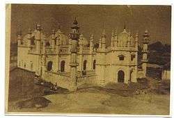
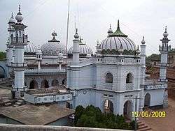
Chitarpur Jama Masjid : Situated In the heart of Chitarpur Village. This Mosque was built in 1700s. It contains magnificent Mughal Art and Structures.
Chaitarpur shivalaya mandir : Situated In Shivalaya Road of Chitarpur.
Rajrappa Temple: It is situated 10 kilometers away from Chitarpur.
.[5]
Education
Chitarpur Village holds numbers of private & government schools and Colleges .[6]
Chitarpur High School : School was built in 1950
Chitarpur Girls Urdu High School (Banat) : School was established at around 1980
D.A.V Public School C.C.L : Is The Only C.B.S.E English Medium school Situated Nearby
Chitarpur Inter College : College was established in 1982
Government Engineering College Ramgarh : Is the only Technical Institute situated nearby and has been recently inaugurated and affiliated by AICTE. Run and Managed by Techno India Group.
Demographics
As per 2011 Census of India Chitarpur had a population of 22,837. There were 11,993 males and 10,844 females. Scheduled Castes numbered 940 and Scheduled Tribes numbered 328. [2]
References
- "Maps, Weather, and Airports for Chitarpur, India". fallingrain.com. Retrieved 18 November 2015.
- "2011 Census C.D. Block Wise Primary Census Abstract Data(PCA)". Jharkhand – District-wise CD Blocks. Registrar General and Census Commissioner, India. Retrieved 15 November 2015.
- "Areas". Argada. CCL. Archived from the original on 26 October 2015. Retrieved 16 December 2015.
- "Areas". Argada. CCL. Archived from the original on 26 October 2015. Retrieved 16 December 2015.
- "Areas". Argada. CCL. Archived from the original on 26 October 2015. Retrieved 16 December 2015.
- "Areas". Argada. CCL. Archived from the original on 26 October 2015. Retrieved 16 December 2015.