Chichigalpa
Chichigalpa (Spanish pronunciation: [ˈtʃitʃiˈɣalpa]) is a town and municipality in the Chinandega Department of Nicaragua.
Chichigalpa | |
|---|---|
Municipality | |
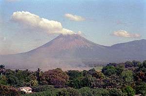 Volcano San Cristobal, Chichigalpa. | |
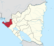
 Chichigalpa Location in Nicaragua | |
| Coordinates: 12°34′N 87°02′W | |
| Country | |
| Department | Chinandega Department |
| Founded | 1839 |
| Government | |
| • Mayor | Víctor Manuel Sevilla |
| Area | |
| • Municipality | 87 sq mi (225 km2) |
| • Metro | 1.4 sq mi (3.5 km2) |
| Population (2005) | |
| • Municipality | 49,793 |
History
Pre-Columbian
It is presumed that Chichigalpa's first inhabitants arrived from the north. While their civilizations were not as advanced as those of the Aztecs and the Incans, they arrived at Chichigalpa due to a forced migration instituted by the Aztecs on weaker tribes. Of Toltec origin, the native people of Chichigalpa were the Niquiranos and Chorotegas.
Colonial Period
Geography
Area
The municipality covers an area of 225 km2, but only about 3.5 km2 make up the center of the municipality and its nearby surroundings. Chichigalpa is connected to the city of Chinandega by a paved road (15 km). The municipality connects to the Nicaraguan capital, Managua, through the Pan-American Highway. Chichigalpa forms part of the Western department of Chinandega. It is bordered to the north by the Cordillera Los Maribios (a mountain range), to the south by León, to the east by Posoltega, and to the west by the municipalities of El Realejo and Chinandega.
Climate
Chichigalpa is situated in tropical wet and dry climate (Köppen climate classification: Aw). The dry season last from November to April while the wet season extends from May to October. The average annual precipitation is of 1742 mm (68.58 in). Temperatures are usually the highest in the month of April. [1] The average temperature is 30°C (89°F). Relative humidity is 68% and strong winds blow in a northeast to south direction predominantly.
Today
Sugarcane
Sugar accounts from about 5% of Nicaragua’s GDP and the municipality of Chichigalpa has vast areas of sugarcane plantations. A large number of the sugar cane workers have been affected with a chronic kidney disease (CKD). There is a growing scientific view that CKD is linked to harsh work conditions, particularly long hours exposed to sun without sufficient shade, rest and water. Dr Catharina Wesseling, an epidemiologist based at the Karolinska Institute in Sweden said that while other factors - such as pesticides, heavy metals and genetics – could also play a part, there was “absolutely no doubt” that CKD was an occupational disease.[2]
Neighborhoods (Barrios)
The municipality is further divided into many neighborhoods (barrios):
|
|
|
|
References
- "Climate: Chichigalpa". Climate-Data.org. Retrieved 28 June 2014.
- https://www.theguardian.com/world/2015/feb/16/-sp-nicaragua-kidney-disease-killing-sugar-cane-workers
External links
| Wikimedia Commons has media related to Chichigalpa. |
Bibliography
- Historia del Municipio de Chichigalpa (translated into English). 2000.
- Sinopsis Histórica de Chichigalpa (translated into English).
- this article incorporates text translated from Spanish Wikipedia