Chevron Island
The Chevron Island is an urban island that lies in the Nerang River and is a neighbourhood within the suburb of Surfers Paradise in the City of Gold Coast, Queensland, Australia.[2][3]
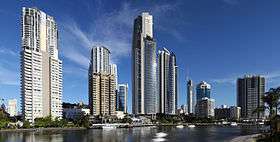 Surfers Paradise skyline, as seen from Chevron Island, 2013. | |
Chevron Island in Open Street Map, 2015 | |
| Geography | |
|---|---|
| Location | Nerang River |
| Total islands | 2 |
| Major islands | Chevron; Cronin |
| Highest elevation | 2 m (7 ft)[1] |
| Administration | |
AUS | |
| State | Queensland |
| Region | Gold Coast, South East Qld |
| Largest settlement | Surfers Paradise |
History
Chevron Island is a natural island previously known as Goat Island.[4][5] Goat Island hosted a cattle farm. The name Goat Island originated from when the original farm had a large goat population. Although it was a cattle farm, the goats helped keep the tougher vegetation from taking over. The goats were moved on after the sale of the farm and no records show what happened to them afterwards.
The Gold Coast has many man-made islands created from land reclamation; however Chevron Island (Goat Island) already existed.[6] The shape and height of the island were added to with sand fill and also by detaching the island from where HOTA now exists in the 1950s. Chevron Island also had a landing point for the barge/ferry crossing the Nerang River to Cavill Avenue.[7] Prior to land reclamation, the Nerang River was wide and shallow with many sandbanks with shifting riverbanks. Through dredging, deeper channels were created for shipping in the river with the spoil being used to create inhabitable islands and permanent river edge embankments, all of which facilitated residential and commercial development.[8][9]
Geography
Chevron Island is a medium density residential area. It is connected by two bridges to Southport and Bundall to the west and to the coastal strip of Surfers Paradise to the east with Thomas Drive continuing from Slatyer Road in Southport/Bundall through to Elkhorn Avenue in coastal strip of Surfers Paradise.[10]
The island has an elevation of 2 metres (6 ft 7 in) above sea level[1] at the mean high tide mark.
Cronin Island (27°59′34″S 153°25′06″E) is another small reclaimed island accessible from Chrevon Island and also lies within the Nerang River.[11][12]
References
- Ryan, J. K.; Waltham, Nathan J.; Benfer, Nathan P.; King, Brian A.; Lemckert, Charles J.; Zigic, Sasha (2013). "Gold Coast Broadwater: Southern Moreton Bay, Southeast Queensland (Australia)". In Wolanski, Eric (ed.). Estuaries of Australia in 2050 and beyond. Dordrecht Springer. pp. 93–109. ISBN 978-94-007-7019-5.
- "Chevron Island - island (entry 7046)". Queensland Place Names. Queensland Government. Retrieved 30 September 2015.
- "Chevron Island - neighbourhood (entry 7047)". Queensland Place Names. Queensland Government. Retrieved 30 September 2015.
- "Surfers Paradise". Queensland Places. Centre for the Government of Queensland, University of Queensland. Retrieved 17 June 2019.
- Wright, Karen. "Southport Stories" (PDF). Gold Coast City Council. p. 2. Archived (PDF) from the original on 17 June 2019. Retrieved 17 June 2019.
- Zerna, Jennifer. "Southport Stories" (PDF). Gold Coast City Council. p. 85. Retrieved 14 August 2018.
- "City of Gold Coast: Thomas Drive, Chevron Island". www.goldcoast.qld.gov.au. Retrieved 30 September 2015.
- "Nerang River Catchment". City of Gold Coast. Retrieved 28 September 2015.
- "History of the Gold Coast Seaway". Gold Coast Waterways Authority. 28 August 2013. Retrieved 1 October 2015.
- "Queensland Globe". State of Queensland. Retrieved 30 September 2015.
- "Cronin Island - island (entry 8804)". Queensland Place Names. Queensland Government. Retrieved 30 September 2015.
- "Cronin Island - neighbourhood (entry 8805)". Queensland Place Names. Queensland Government. Retrieved 30 September 2015.