Chetlat Island
Chetlat Island is a coral island belonging to the Amindivi Subgroup of islands of the Lakshadweep archipelago in India. It has a distance of 1,933 km (1,201 mi) south of the city of Delhi.
 Chetlat Island Location of Chetlat Island in Lakshadweep | |
| Geography | |
|---|---|
| Location | Arabian Sea |
| Coordinates | 11°41′N 72°42′E |
| Archipelago | Lakshadweep |
| Adjacent bodies of water | Indian Ocean |
| Total islands | 1 |
| Major islands |
|
| Area | 1.174 km2 (0.453 sq mi)[1] |
| Highest elevation | 2 m (7 ft) |
| Administration | |
| Territory | Union territory of Lakshadweep |
| District | Lakshadweep |
| Island group | Aminidivi |
| Tehsils of India | Aminidivi |
| Subdivisions of India | Chetlat Island |
| Largest settlement | Chetlat (pop. 10) |
| Demographics | |
| Population | 2400 (2016) |
| Pop. density | 2,044/km2 (5,294/sq mi) |
| Ethnic groups | Malayali, Mahls |
| Additional information | |
| Time zone | |
| PIN | 68255x |
| Telephone code | 0489x |
| ISO code | IN-LD-02[2] |
| Official website | www |
| Literacy | 84.4% |
| Avg. summer temperature | 32.0 °C (89.6 °F) |
| Avg. winter temperature | 28.0 °C (82.4 °F) |
| Sex ratio | 50% ♂/♀ |
History
Local history says that islanders were cruelly treated by Portuguese seafarers in the past.[3]
Coir twisting was the traditional occupation of the inhabitants and average Chetlat coir used to be equal to first-class coir of the other islands in Lakshadweep.[4]
Geography
Chetlat is one of the populated islands of Lakshadweep. It is located 37 km to the northwest of Kiltan Island. The reef and lagoon are located to the west of the island and the total dry land area is 1.174 km2 (0.453 sq mi).[5] There is a small scale yearly growing sand spit on the northern point of the island. It has a lagoon area of 3.79 km2 (1.46 sq mi).
Administration
Chetlat is the sole inhabited island of the township of Chetlat Island of Aminidivi Tehsil.[6]
Economics
The inhabitants on the island are engaged in very small scale farming and fishing which are mainly for the island consumption.
Transportation
The island has a small jetty on the west coast and a helipad on southpoint.
Image gallery
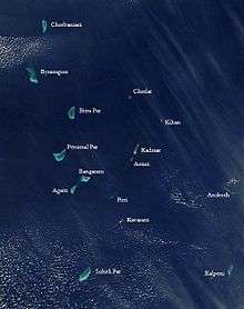 Satellite picture showing the atolls of the Lakshadweep except for Minicoy
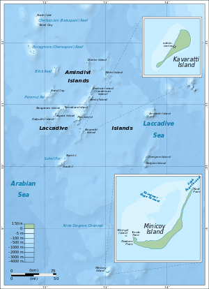 Map
Map
References
- "Islandwise Area and Population - 2011 Census" (PDF). Government of Lakshadweep. Archived from the original (PDF) on 22 July 2016.
- Registration Plate Numbers added to ISO Code
- Chetlat
- R. H. Ellis, A short account of the Laccadive Islands and Minicoy, AES reprint 1992
- Hydrographic Description (Indian Ocean Pilot)
- "Tehsils info" (PDF). Archived from the original (PDF) on 21 July 2011. Retrieved 26 April 2016.
External links

- Lagoon sizes
- Chetlat - Geographical information
- Chetlat - Oceandots at the Wayback Machine (archived 23 December 2010)
- List of Atolls
- An ornithological expedition to the Lakshadweep archipelago
- Sources towards a history of the Laccadive Islands
- FAO - An analysis of the carrying Capacity of Lakshadweep Coral Reefs