Chattanooga, Oklahoma
Chattanooga is a town in Comanche and Tillman counties in the U.S. state of Oklahoma. The population was 461 at the 2010 census. The Comanche County portion of Chattanooga is included in the Lawton, Oklahoma Metropolitan Statistical Area.
Chattanooga, Oklahoma | |
|---|---|
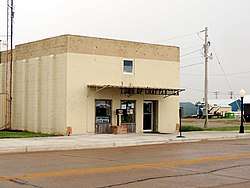 Chattanooga, Oklahoma City Hall | |
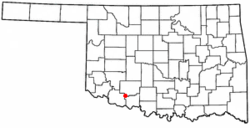 Location of Chattanooga, Oklahoma | |
| Coordinates: 34.4242471°N 98.6540892°W | |
| Country | United States |
| State | Oklahoma |
| Counties | Comanche, Tillman |
| Area | |
| • Total | 0.57 sq mi (1.47 km2) |
| • Land | 0.57 sq mi (1.47 km2) |
| • Water | 0.00 sq mi (0.00 km2) |
| Elevation | 1,152 ft (351 m) |
| Population (2010) | |
| • Total | 461 |
| • Estimate (2018)[2] | 444 |
| • Density | 781.69/sq mi (301.86/km2) |
| Time zone | UTC-6 (Central (CST)) |
| • Summer (DST) | UTC-5 (CDT) |
| ZIP code | 73528 |
| Area code(s) | 580 |
| FIPS code | 40-13600[3] |
| GNIS feature ID | 1091220[4] |
Geography
Chattanooga is located at 34°25′23″N 98°39′18″W (34.423012, −98.655030).[5]
According to the United States Census Bureau, the town has a total area of 0.6 square miles (1.5 km2), all land.
Climate
| Climate data for Chattanooga, Oklahoma | |||||||||||||
|---|---|---|---|---|---|---|---|---|---|---|---|---|---|
| Month | Jan | Feb | Mar | Apr | May | Jun | Jul | Aug | Sep | Oct | Nov | Dec | Year |
| Average high °F (°C) | 50.6 (10.3) |
56.8 (13.8) |
64.9 (18.3) |
74.2 (23.4) |
83.3 (28.5) |
92.8 (33.8) |
98.6 (37.0) |
97.3 (36.3) |
88.7 (31.5) |
77.8 (25.4) |
63.2 (17.3) |
52.8 (11.6) |
75.1 (23.9) |
| Average low °F (°C) | 23.8 (−4.6) |
28.1 (−2.2) |
35.7 (2.1) |
45.4 (7.4) |
56.1 (13.4) |
65.8 (18.8) |
69.4 (20.8) |
68.6 (20.3) |
61.1 (16.2) |
49.9 (9.9) |
36.0 (2.2) |
26.8 (−2.9) |
47.2 (8.4) |
| Average precipitation inches (mm) | 1.06 (27) |
1.49 (38) |
2.49 (63) |
2.66 (68) |
4.86 (123) |
4.03 (102) |
2.22 (56) |
2.56 (65) |
3.26 (83) |
3.12 (79) |
1.77 (45) |
1.60 (41) |
31.12 (790) |
| Average precipitation days (≥ 0.01 in) | 3.2 | 3.7 | 4.8 | 4.8 | 6.8 | 5.8 | 3.9 | 4.7 | 5.3 | 4.8 | 3.7 | 3.6 | 55.1 |
| Average snowy days (≥ 0.1 in) | 0.5 | 0.4 | 0.1 | 0 | 0 | 0 | 0 | 0 | 0 | 0 | 0.3 | 0.3 | 1.6 |
| Source: NOAA (normals, 1971−2000) [6] | |||||||||||||
Demographics
| Historical population | |||
|---|---|---|---|
| Census | Pop. | %± | |
| 1910 | 471 | — | |
| 1920 | 507 | 7.6% | |
| 1930 | 362 | −28.6% | |
| 1940 | 365 | 0.8% | |
| 1950 | 333 | −8.8% | |
| 1960 | 356 | 6.9% | |
| 1970 | 302 | −15.2% | |
| 1980 | 403 | 33.4% | |
| 1990 | 437 | 8.4% | |
| 2000 | 432 | −1.1% | |
| 2010 | 461 | 6.7% | |
| Est. 2018 | 444 | [2] | −3.7% |
| U.S. Decennial Census[7] | |||
As of the census of 2010, there were 461 people, 179 households, and 128 families residing in the town. The population density was 882.1 people per square mile (313.6/km2). There were 206 housing units at an average density of 362.7 per square mile (140.0/km2). The racial makeup of the town was 86.3% White, 0.2% African American, 7.8% Native American, 1.1% from other races, and 3.5% from two or more races. Hispanic or Latino of any race were 5.0% of the population.
There were 179 households, out of which 33.0% had children under the age of 18 living with them, 55.3% were married couples living together, 12.8% had a female householder with no husband present, and 28.5% were non-families. 22.9% of all households were made up of individuals, and 11.2% had someone living alone who was 65 years of age or older. The average household size was 2.58 and the average family size was 3.03.
In the town, the population was spread out, with 26.5% under the age of 18, 7.8% from 18 to 24, 29.2% from 25 to 44, 25.4% from 45 to 64, and 12.6% who were 65 years of age or older. The median age was 38.3 years. For every 100 females, there were 95.3 males. For every 100 females age 18 and over, there were 98.2 males.
According to the 2000 census, the median income for a household in the town was $26,944, and the median income for a family was $38,750. Males had a median income of $24,545 versus $19,821 for females. The per capita income for the town was $12,989. About 7.1% of families and 13.2% of the population were below the poverty line, including 11.6% of those under age 18 and 12.2% of those age 65 or over.
References
- "2018 U.S. Gazetteer Files". United States Census Bureau. Retrieved Feb 12, 2020.
- "Population and Housing Unit Estimates". Retrieved June 4, 2019.
- "U.S. Census website". United States Census Bureau. Retrieved 2008-01-31.
- "US Board on Geographic Names". United States Geological Survey. 2007-10-25. Retrieved 2008-01-31.
- "US Gazetteer files: 2010, 2000, and 1990". United States Census Bureau. 2011-02-12. Retrieved 2011-04-23.
- "Climatography of the United States NO. 20 1971−2000: Lawton, OK" (PDF). National Oceanic and Atmospheric Administration. Archived from the original (PDF) on 2014-09-05. Retrieved 2011-10-02.
- "Census of Population and Housing". Census.gov. Retrieved June 4, 2015.
External links
Municipalities and communities of Comanche County, Oklahoma, United States | ||
|---|---|---|
| Cities |  Comanche County map | |
| Towns | ||
| Unincorporated communities | ||
| Footnotes | ‡This populated place also has portions in an adjacent county or counties | |
Municipalities and communities of Tillman County, Oklahoma, United States | ||
|---|---|---|
| Cities | 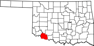 Tillman County map | |
| Towns | ||
| Footnotes | ‡This populated place also has portions in an adjacent county or counties | |