Chalong, Phuket
Chalong (Thai: ฉลอง, pronounced [t͡ɕʰā.lɔ̌ːŋ]) is a sub-district (tambon) in the southern portion of Phuket Province, Thailand. It is one of eight sub-districts in the capital district (amphoe mueang) Mueang Phuket.
Chalong ฉลอง | |
|---|---|
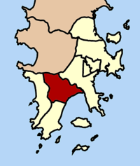 Location of Chalong in Mueang Phuket | |
| Coordinates: 7°50′23″N 98°20′43″E | |
| Country | Thailand |
| Province | Phuket |
| District | Mueang Phuket |
| Area | |
| • Total | 34.069 km2 (13.154 sq mi) |
| Population (2005) | |
| • Total | 15,460 |
| • Density | 450/km2 (1,200/sq mi) |
| Postal Code | 83000 (Villages 1-5) 83100 (Villages 6-10) |
| Geocode | 830106 |
Sights
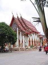
The most important of the 29 Buddhist temples on Phuket is Wat Chalong (วัดฉลอง, วัดไชยธาราราม). It is dedicated to two monks, Luang Pho Chaem (หลวงพ่อแช่ม) and Luang Pho Chuang (หลวงพ่อช่วง), who with their knowledge of herbal medicine helped the injured of a tin miners rebellion in 1876.
Geography
Neighboring tambons are (from south clockwise) Rawai, Karon, Patong, and Kathu of Kathu District and Wichit. To the southeast is Chalong Bay, with one of touristy beaches of the island.
Administration
The tambon is administered by a tambon administrative organization (TAO) created in 1995.[1] It is divided into 10 villages (muban).
- Khao Noi (เขาน้อย)
- Bon Suan (บนสวน)
- Pa Lai (ป่าไล่)
- Na Yai (นาใหญ่)
- Na Kok (นากก)
- Chalong (ฉลอง)
- Wat Mai (วัดใหม่)
- Khok Sai (โคกทราย)
- Khok Tanot (โคกโตนด)
- Yot Sane (ยอดเสน่ห์)
Climate
| Climate data for Phuket (Station 48564, 07°53′N 98°24′E, 1961–1990) | |||||||||||||
|---|---|---|---|---|---|---|---|---|---|---|---|---|---|
| Month | Jan | Feb | Mar | Apr | May | Jun | Jul | Aug | Sep | Oct | Nov | Dec | Year |
| Record high °C (°F) | 35.5 (95.9) |
36.2 (97.2) |
37.5 (99.5) |
36.8 (98.2) |
36.0 (96.8) |
35.0 (95.0) |
34.0 (93.2) |
34.5 (94.1) |
33.3 (91.9) |
33.9 (93.0) |
33.4 (92.1) |
33.5 (92.3) |
37.5 (99.5) |
| Average high °C (°F) | 31.8 (89.2) |
32.9 (91.2) |
33.5 (92.3) |
33.4 (92.1) |
32.0 (89.6) |
31.6 (88.9) |
31.2 (88.2) |
31.2 (88.2) |
30.7 (87.3) |
30.9 (87.6) |
31.0 (87.8) |
31.2 (88.2) |
31.8 (89.2) |
| Daily mean °C (°F) | 27.9 (82.2) |
28.7 (83.7) |
29.3 (84.7) |
29.5 (85.1) |
28.4 (83.1) |
28.3 (82.9) |
27.8 (82.0) |
27.9 (82.2) |
27.3 (81.1) |
27.4 (81.3) |
27.5 (81.5) |
27.6 (81.7) |
28.1 (82.6) |
| Average low °C (°F) | 23.3 (73.9) |
23.7 (74.7) |
24.3 (75.7) |
24.8 (76.6) |
24.5 (76.1) |
24.5 (76.1) |
24.2 (75.6) |
24.4 (75.9) |
23.9 (75.0) |
23.8 (74.8) |
23.8 (74.8) |
23.7 (74.7) |
24.1 (75.4) |
| Record low °C (°F) | 17.8 (64.0) |
17.1 (62.8) |
18.5 (65.3) |
21.1 (70.0) |
20.7 (69.3) |
20.5 (68.9) |
21.0 (69.8) |
20.7 (69.3) |
21.2 (70.2) |
21.0 (69.8) |
19.8 (67.6) |
17.2 (63.0) |
17.1 (62.8) |
| Average precipitation mm (inches) | 29.8 (1.17) |
20.9 (0.82) |
49.1 (1.93) |
121.9 (4.80) |
319.4 (12.57) |
268.9 (10.59) |
290.5 (11.44) |
272.6 (10.73) |
399.0 (15.71) |
309.6 (12.19) |
175.7 (6.92) |
59.4 (2.34) |
2,316.8 (91.21) |
| Average rainy days | 4 | 3 | 5 | 11 | 21 | 19 | 19 | 19 | 23 | 22 | 16 | 8 | 170 |
| Mean monthly sunshine hours | 286.2 | 271.5 | 282.3 | 247.9 | 188.5 | 139.5 | 172.6 | 174.1 | 143.2 | 179.8 | 197.1 | 244.3 | 2,527 |
| Source 1: Thai Meteorological Department,[2] Hong Kong Observatory [3] | |||||||||||||
| Source 2: NOAA (sun, extremes)[4] | |||||||||||||
References
- ประกาศกระทรวงมหาดไทย เรื่อง จัดตั้งองค์การบริหารส่วนตำบล (จำนวน ๖๑๘ แห่ง) (PDF). Royal Gazette (in Thai). 112 (พิเศษ 6 ง): 1–64. March 3, 1995.
- "30 year Average (1961-1990) - PHUKET". Thai Meteorological Department. Archived from the original on 2010-02-14. Retrieved 2010-04-20.
- "Climatological Normals of Phuket". Hong Kong Observatory. Retrieved 2011-11-13.
- "PHUKET INTL AIRPORT 1961-1990". National Oceanic and Atmospheric Administration. Retrieved 13 September 2012.
External links

- phuketchalong.go.th Chalong TAO (Thai)
- thaitambon.com (Thai)
- Chalong local weather station (English)