Chalatenango Department
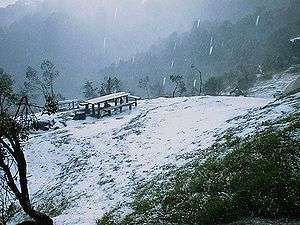
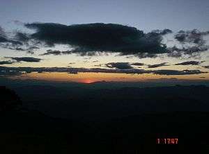
Chalatenango is a department of El Salvador, located in the northwest of the country. The capital is the city of Chalatenango. The Chalatenango Department encompasses 2,017 km² and contains more than 204,000 inhabitants. Las Matras Archaeological Ruins contains the relics of prehistoric populations and caves in which rock writing is found. The "5 de Noviembre" Hydroelectric Dam is found in Chalatenango Department, near the border with Cabañas. The highest point in the country, El Pital with an elevation of 2730.06 m, is also located in Chalatenango Department.
Chalatenango | |
|---|---|
 | |
 Flag | |
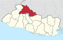 Location within El Salvador | |
| Coordinates: 14°10′23″N 89°04′34″W | |
| Country | |
| Created (given current status) | 1855 |
| Seat | Chalatenango |
| Area | |
| • Total | 2,016.6 km2 (778.6 sq mi) |
| Area rank | Ranked 5th |
| Highest elevation | 2,730 m (8,960 ft) |
| Population | |
| • Total | 204,888 |
| • Rank | Ranked 10th |
| • Density | 100/km2 (260/sq mi) |
| Time zone | UTC−5 (CST) |
| ISO 3166 code | SV-CH |
| Website | www |
Agriculture
The most cultivated agricultural products are the basic grains, henequen (a type of agave), coffee, fruits, orchard plants, and vegetables, horses and cattle, and wilderness agriculture. Moreover, plaster, gold, lime, clay lead, silver, and zinc can be found there.
History
Around 1790, Francisco Luis Héctor de Carondelet, Governor of El Salvador, found that the local indigenous population working in Chaletenango's indigo industry had declined greatly. Carondolet responded by bringing poor Spaniards from Galicia, Asturias and Cantabria to settle, with the result that many blond and light skinned/eyed people may still be found in the Chalatenango Department today.[1]
Chalatenango was made a department on February 14, 1855.
During the 1980s, the department was the stronghold of the Farabundo Martí Popular Forces of Liberation (FPL), one of the two largest groups in the Frente Farabundo Martí Para la Liberacion Nacional (FMLN).
Municipalities
- Agua Caliente
- Arcatao
- Azacualpa
- Chalatenango
- Citalá
- Comalapa
- Concepción Quezaltepeque
- Dulce Nombre de María
- El Carrizal
- El Paraíso
- La Laguna
- La Palma
- La Reina
- Las Vueltas
- Nombre de Jesús
- Nueva Concepción
- Nueva Trinidad
- Ojos de Agua
- Potonico
- San Antonio de la Cruz
- San Antonio Los Ranchos
- San Fernando
- San Francisco Lempa
- San Francisco Morazán
- San Ignacio
- San Isidro Labrador
- San José Cancasque
- San José Las Flores
- San Luis del Carmen
- San Miguel de Mercedes
- San Rafael
- Santa Rita
- Tejutla
References
- "François Louis Hector de Carondelet". Noyelles sur Selle, Carondelet (in French). Retrieved 2013-02-18.
External links
- Alcaldia Municipal de Chalatenango, 2009-2012.
- Atlas Geográfico Universal y de El Salvador. Editorial Oceano. Edición 1995 ISBN 84-494-0135-6
- Sitio web del departamento de Chalatenango