Chacra, Colorado
Chacra is a census-designated place (CDP) in Garfield County, Colorado, United States. The population as of the 2010 census was 329.[1]
Chacra, Colorado | |
|---|---|
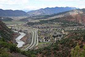 Chacra (on the right) and Interstate-70, and the Colorado River. | |
 Chacra  Chacra | |
| Coordinates: 39°34′43″N 107°27′2″W | |
| Country | |
| State | |
| County | Garfield County |
| Area | |
| • Total | 0.98 sq mi (2.55 km2) |
| • Land | 0.95 sq mi (2.45 km2) |
| • Water | 0.04 sq mi (0.10 km2) |
| Elevation | 5,800 ft (1,800 m) |
| Population (2010) | |
| • Total | 329 |
| • Density | 348/sq mi (134.3/km2) |
| Time zone | UTC-7 (MST) |
| • Summer (DST) | UTC-6 (MDT) |
| Area code(s) | 970 |
| FIPS code | 08-12945 |
| GNIS feature ID | 2583222 |
It is located on the north side of Colorado River, 8 miles (13 km) west of Glenwood Springs, the county seat. Interstate 70 passes through the community, with access from Exit 109. According to the U.S. Census Bureau, the Chacra CDP has a total area of 0.98 square miles (2.55 km2), of which 0.95 square miles (2.45 km2) is land and 0.04 square miles (0.10 km2), or 3.87%, is water.[1]
See also
- Outline of Colorado
- State of Colorado
- Colorado cities and towns
- Colorado census designated places
- Colorado counties
- Colorado cities and towns
References
- "Geographic Identifiers: 2010 Demographic Profile Data (G001): Chacra CDP, Colorado". American Factfinder. U.S. Census Bureau. Retrieved November 16, 2016.
- "Census of Population and Housing". Census.gov. Retrieved June 4, 2016.
| Wikimedia Commons has media related to Chacra, Colorado. |
Municipalities and communities of Garfield County, Colorado, United States | ||
|---|---|---|
| Cities | 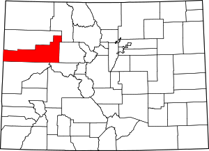 Map of Colorado highlighting Garfield County | |
| Towns | ||
| CDPs | ||
| Unincorporated communities | ||
This article is issued from Wikipedia. The text is licensed under Creative Commons - Attribution - Sharealike. Additional terms may apply for the media files.