Châtillon, Rhône
Châtillon, formerly known as Châtillon-d'Azergues, is a commune in the Rhône département in eastern France.
Châtillon | |
|---|---|
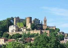 The village of Châtillon d'Azergues | |
.svg.png) Coat of arms | |
Location of Châtillon 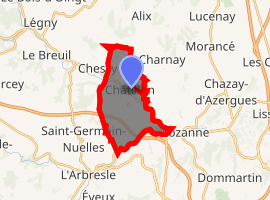
| |
 Châtillon  Châtillon | |
| Coordinates: 45°52′41″N 4°38′46″E | |
| Country | France |
| Region | Auvergne-Rhône-Alpes |
| Department | Rhône |
| Arrondissement | Villefranche-sur-Saône |
| Canton | Le Bois-d'Oingt |
| Intercommunality | Beaujolais Pierres Dorées |
| Government | |
| • Mayor (2014–2020) | Bernard Marconnet |
| Area 1 | 10.71 km2 (4.14 sq mi) |
| Population (2017-01-01)[1] | 2,137 |
| • Density | 200/km2 (520/sq mi) |
| Time zone | UTC+01:00 (CET) |
| • Summer (DST) | UTC+02:00 (CEST) |
| INSEE/Postal code | 69050 /69380 |
| Elevation | 199–334 m (653–1,096 ft) (avg. 216 m or 709 ft) |
| 1 French Land Register data, which excludes lakes, ponds, glaciers > 1 km2 (0.386 sq mi or 247 acres) and river estuaries. | |
Sites and monuments

Cross Châtillon-d'Azergues
The Château de Châtillon-d'Azergues, a ruined 13th to 15th century castle, dominates the village. The 12th century Chapel of Saint-Barthélémy, known as Notre-Dame-de-Bon-Secours, is at the side of the castle.
The chapel was listed in 1862 as a monument historique by the French Ministry of Culture; the castle itself has been listed since 1937.[2]
See also
References
- "Populations légales 2017". INSEE. Retrieved 6 January 2020.
- Ministry of Culture: Châtillon: Château et sa chapelle (in French)
External links
| Wikimedia Commons has media related to Châtillon (Rhône). |
| Authority control |
|
|---|
This article is issued from Wikipedia. The text is licensed under Creative Commons - Attribution - Sharealike. Additional terms may apply for the media files.