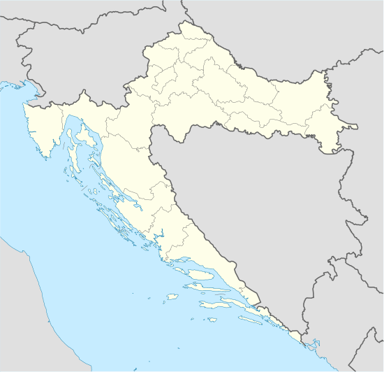
Cetingrad
Cetingrad is a municipality in Karlovac County, Croatia near Croatia's border with Bosnia. The population of the village itself is 319, while the total municipality population is 2,027 (2011).[2] The municipality is part of Kordun. Cetingrad is underdeveloped municipality which is statistically classified as the First Category Area of Special State Concern by the Government of Croatia.[3]
Cetingrad | |
|---|---|
Municipality | |
 | |
 Cetingrad | |
| Coordinates: 45.160°N 15.739°E | |
| Country | |
| County | Karlovac County |
| Government | |
| • Mayor | Milan Gašparin |
| Area | |
| • Total | 136.99 km2 (52.89 sq mi) |
| Population (2011) | |
| • Total | 2,027 |
| Time zone | UTC+1 (Central European Time) |
Administrative division
Cetingrad is today a municipality and part of Karlovac County in Croatia.
According to Roman Catholic organization, the parish of Cetingrad is a part of Slunj deanery, together with Slunj, Blagaj, Cvitović, Lađevac, Rakovica, Drežnik, Vaganac, Zavalje, Korenica and Plitvice.[4]
History
Cetingrad was built in the vicinity of the ruins of the mediaeval fortress of Cetin. The Middle Ages was the golden era of Cetin. Near the fortress there was Franciscan monastery and several churches. At that time Cetin was the property of Frankopan family and it played important role in History of Croatia.
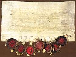
After defeat in Battle of Mohács in 1526 Croatian nobility gathered at Parliament on Cetin (Cetinski Sabor). On January 1, 1527 they elected Habsburg Ferdinand, Archduke of Austria as the king of Croatia.[5] The charter signed by Croatian nobles and representatives of Ferdinand of Habsburg is among most important documents of Croatian statehood and is preserved in Austrian State Archives in Vienna.
In next centuries Cetin was part of Military Frontier, the borderland between Habsburg Monarchy and Ottoman Empire. During this period Ottoman army took control over it several times. The fortress was several times damaged and repaired. In 1790 Austrian troops under the command of general Walisch finally returned Cetin to the Habsburg monarchy.[6]
In 1809 Ottoman forces once again occupied Cetin but in 1810 they withdrew under the threats of Marshal Marmont, governor-general of Illyrian provinces. When the Ottoman threat was gone the fortress was abandoned and used as quarry. Administrative control was transferred to village of Cetingrad which developed north to the Cetin.
In the 19th and 20th century the area was rarely populated and without any real opportunity for economic development. During World War II area once again experienced great suffering and destruction and after the war socialist Yugoslavia neglected this area. Due to poverty population was forced to migrate, first overseas and later to European countries.
During the Yugoslav Wars, Cetingrad and the surrounding area was militarily conquered. It was part of the Republic of Serb Krajina until 1995. Most of Cetingrad's population spent four years in exile. Serb rebels burnt and then destroyed the biggest Roman Catholic church in Slunj deanery (church of Assumption of Mary, crkva Marijina Uznesenja, built in 1891). The church was later rebuilt.[4][5]
In May 1995, Cetingrad was the site of a helicopter crash, caused by a missile fired by Serbs, in which the foreign minister of Bosnia and Herzegovina Irfan Ljubijankić and six others were killed. In August 1995 during the Operation Storm Croatian army took Cetingrad. After 1995, Cetingrad was successfully rebuilt and large number of people returned to their homes.
_Cetingrad_Municipality.PNG)
Demographics
According to the 2011 census, Municipality of Cetingrad has the following ethnic breakdown:[7]
| Ethnic group | Number | Percentage |
|---|---|---|
| Croats | 1,510 | 74.5% |
| Bosniaks | 314 | 15.5% |
| Serbs | 101 | 5.0% |
Towns and villages in municipality
- Batnoga
- Begovo Brdo (Cetingrad)
- Bilo (Cetingrad)
- Bogovolja
- Buhača
- Cetinski Varoš
- Delić Poljana
- Donja Žvrnica
- Donje Gnojnice
- Đurin Potok
- Glinice
- Gojkovac
- Gornja Žrvnica
- Gornje Gnojnice
- Grabarska
- Kapljuv
- Kestenje
- Komesarac
- Kruškovača
- Kuk
- Luke
- Maljevac
- Maljevačko Selište
- Pašin Potok
- Podcetin
- Polojski Varoš
- Ponor (Cetingrad)
- Ruševica
- Sadikovac
- Srednje Selo
- Strmačka
- Šiljkovača
- Tatar Varoš
- Trnovi

Culture
Cetingrad is home to a monument to Croatian soldiers from the Croatian War of Independence.[8] The town celebrates August 7 as its municipal day to commemorate its liberation from the rebel Republic of Serb Krajina on that day in 1995.[9]
Notes
- "Općine na područjima posebne državne skrbi Republike Hrvatske" (PDF). Croatian Chamber of Economy. Retrieved 21 April 2020.
- "Population by Age and Sex, by Settlements, 2011 Census: Cetingrad". Census of Population, Households and Dwellings 2011. Zagreb: Croatian Bureau of Statistics. December 2012.
- Lovrinčević, Željko; Davor, Mikulić; Budak, Jelena (June 2004). "AREAS OF SPECIAL STATE CONCERN IN CROATIA- REGIONAL DEVELOPMENT DIFFERENCES AND THE DEMOGRAPHIC AND EDUCATIONAL CHARACTERISTICS". Ekonomski pregled, Vol.55 No.5-6. Archived from the original on 2018-08-18. Retrieved 25 August 2018.
- "Slunjski dekanat - župe". gospicko-senjska-biskupija.hr (in Croatian). Retrieved 17 September 2017.
- Nadilo 2002, p. 695.
- Nadilo 2002, p. 694.
- "Population by Ethnicity, by Towns/Municipalities, 2011 Census: County of Karlovac". Census of Population, Households and Dwellings 2011. Zagreb: Croatian Bureau of Statistics. December 2012.
- Cetingrad ljepši nego prije Domovinskog rata
- Cetingrad
Sources
- Radoslav Lopašić: Oko Kupe i Korane, Matica Hrvatska, 1895, Zagreb
- Milan Kruhek: Cetin, grad izbornog sabora Kraljevine Hrvatske 1527, Karlovačka Županija, 1997, Karlovac
- Iz memoara maršala Marmonta: ilirske uspomene 1806-1811, Čakavski Sabor, 1977, Split
- Nadilo, Branko (2002). "Pregled utvrda južnog Korduna i ruševine Cetingrada" (PDF). Građevinar (in Croatian). 54 (11): 691–695. Retrieved 17 September 2017.CS1 maint: ref=harv (link)
External links
| Wikimedia Commons has media related to Cetingrad. |
- Cetingrad - official site
- Unofficial site of Municipality of Cetingrad
- Cetingrad - village in the Kordun Region
- Cetingrad in the online Proleksis Enciklopedija
Subdivisions of Karlovac County | ||
|---|---|---|
| Cities and towns |  Coat of arms of Karlovac County | |
| Municipalities | ||