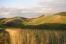
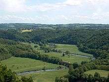
Central Uplands
The Central Uplands[1][2] (German: die Mittelgebirge[3]) is one of the three major natural regions of Germany and covers most of the land area of the country. To the north lies the North German Plain or Northern Lowland; to the south, the Alps and the Alpine Foreland.[1]
Formation
The German Central Uplands, like the Scandinavian and British mountain ranges and the Urals, belong to the oldest mountains of Europe, even if their present-day appearance has only developed relatively recently. In the Carboniferous, i.e. about 350 million years ago, Variscan mountain ranges were formed in central Europe by the uplifting caused by tectonic plate collision. Immediately after their formation the erosion of the mountains began under the influence of exogenous processes during the Permian period. During the Triassic period, which began about 225 million years ago, what is now central Europe was sometimes above and sometimes below sea level. As a result, there are various layers of sedimentary rock in the Central Uplands: in most cases new red sandstone has been laid down as the terrestrial layer of rock and keuper and muschelkalk as marine sedimentary layers. The Jurassic period primarily saw the formation of limestone, whilst chalk was the main deposition from the Cretaceous period.
With the beginning of the Cenozoic era, some 70 million years ago, the process of erosion of the Hercynian mountain ranges changed. During the Tertiary, alpidic mountain building took place, in the course of which strong forces deformed the stumps of the Hercynian mountains. As these rocks were already folded, further tension led to cracks and fractures, which in turn created fault blocks. These blocks were later uplifted (forming horsts such as the Harz), or downfaulted (trough faults or graben such as the Upper Rhine Valley) or thrust over one another (tilted fault blocks such as the Ore Mountains). Thus the German Central Uplands exhibit the widest variety of forms, something that is also attributable to the erosion of sediments from the Mesozoic (Triassic, Jurassic and Cretaceous). In some ranges the sediments have been relatively well-preserved, in others they have been carried away completely. The determining factor is the geographical location and associated intensity of exogenous processes.
Most important ranges
The following table lists the mountains and hills over 300 m high that are generally considered to be part of the Central Uplands. The coordinates give the location of the highest point in each case. Many of the uplands overlap. The ranges are listed in order of height.

See also
- Geography of Germany
- Mittelgebirge, generic German term for low mountain or high hill ranges
- Natural regions of Germany
References
- Dickinson (1964), p.18 ff.
- Elkins, T H (1972). Germany (3rd ed.). London: Chatto & Windus, p. 13. ASIN B0011Z9KJA.
- N.B. In German die Mittelgebirge (plural) refers to the Central Uplands; das Mittelgebirge refers to a low mountain range or upland region (Mittel = "medium" and -gebirge = "range").
Sources
- Dickinson, Robert E (1964). Germany: A regional and economic geography (2nd ed.). London: Methuen. ASIN B000IOFSEQ.
External links
![]()
![]()
