Cazenovia, New York
Cazenovia is a town in Madison County, New York, United States. The population was 7,086 at the 2010 census.[3] The town is named after Theophilus Cazenove, an agent of the Holland Land Company.
Cazenovia | |
|---|---|
Town | |
 | |
 Cazenovia Location within the state of New York | |
| Coordinates: 42.9315°N 75.8526°W | |
| Country | United States |
| State | New York |
| County | Madison |
| Government | |
| • Town Supervisor | Ralph M. Monforte (R) |
| • Town Council | Members
|
| Area | |
| • Total | 51.79 sq mi (134.14 km2) |
| • Land | 49.94 sq mi (129.35 km2) |
| • Water | 1.85 sq mi (4.79 km2) |
| Population (2010) | |
| • Total | 7,086 |
| • Estimate (2016)[2] | 7,012 |
| • Density | 140.40/sq mi (54.21/km2) |
| Time zone | UTC-5 (EST) |
| • Summer (DST) | UTC-4 (EDT) |
| Area code(s) | 315 |
| FIPS code | 36-053-13156 |
| Website | Town website |
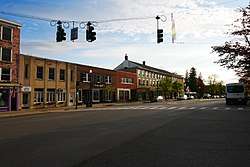
The Town of Cazenovia has a village also named Cazenovia. The town is on the county's western border.
The village of Cazenovia is home to Cazenovia College, a small liberal arts college in the greater Syracuse area. It was founded in 1824, known then as the Genesee Seminary.
History

The Town of Cazenovia was established in 1793 by the Towns of Whitestown and Paris (both in Oneida County) before the creation of Madison County. Subsequently, other towns in the county were formed from partitions of its territory. Cazenovia was part of a region called "The Gore," based on a surveying error.
It was founded by John Lincklaen, an agent of the Holland Land Company, and was named after Theophilus Cazenove, Lincklaen's boss.
Geography
According to the United States Census Bureau, the town has a total area of 51.7 square miles (134.0 km²), with 49.9 square miles (129.2 km²) of land and 1.8 square miles (4.7 km²) of (3.54%) water. The Town contains Cazenovia Lake.
The west town line is the border of Onondaga County.
U.S. Route 20, also known as Albany Street, crosses the town.
Demographics
| Historical population | |||
|---|---|---|---|
| Census | Pop. | %± | |
| 1820 | 3,909 | — | |
| 1830 | 4,344 | 11.1% | |
| 1840 | 4,153 | −4.4% | |
| 1850 | 4,812 | 15.9% | |
| 1860 | 4,343 | −9.7% | |
| 1870 | 4,265 | −1.8% | |
| 1880 | 4,363 | 2.3% | |
| 1890 | 4,182 | −4.1% | |
| 1900 | 3,830 | −8.4% | |
| 1910 | 3,687 | −3.7% | |
| 1920 | 3,343 | −9.3% | |
| 1930 | 3,504 | 4.8% | |
| 1940 | 3,424 | −2.3% | |
| 1950 | 3,969 | 15.9% | |
| 1960 | 4,968 | 25.2% | |
| 1970 | 6,092 | 22.6% | |
| 1980 | 5,880 | −3.5% | |
| 1990 | 6,514 | 10.8% | |
| 2000 | 6,481 | −0.5% | |
| 2010 | 7,086 | 9.3% | |
| Est. 2016 | 7,012 | [2] | −1.0% |
| U.S. Decennial Census[4] | |||
As of the census[5] of 2000, there were 6,481 people, 2,353 households, and 1,658 families residing in the town. The population density was 129.9 people per square mile (50.2/km²). There were 2,567 housing units at an average density of 51.5 per square mile (19.9/km²). The racial makeup of the town was 97.25% White, 1.10% Black or African American, 0.26% Native American, 0.52% Asian, 0.15% from other races, and 0.69% from two or more races. Hispanic or Latino of any race were 1.48% of the population.
There were 2,353 households out of which 32.3% had children under the age of 18 living with them, 61.0% were married couples living together, 6.8% had a female householder with no husband present, and 29.5% were non-families. 24.5% of all households were made up of individuals and 12.3% had someone living alone who was 65 years of age or older. The average household size was 2.51 and the average family size was 3.02.
In the town, the population was spread out with 24.0% under the age of 18, 12.8% from 18 to 24, 23.5% from 25 to 44, 25.2% from 45 to 64, and 14.5% who were 65 years of age or older. The median age was 39 years. For every 100 females, there were 88.7 males. For every 100 females age 18 and over, there were 83.1 males.
The median income for a household in the town was $57,232, and the median income for a family was $73,590. Males had a median income of $50,556 versus $31,613 for females. The per capita income for the town was $28,957. About 2.4% of families and 4.3% of the population were below the poverty line, including 1.9% of those under age 18 and 6.7% of those age 65 or over.
Communities and locations in the Town of Cazenovia
- Abell Corners – A location east of Ballina.
- Ballina – A location south of the village of Cazenovia.
- Cazenovia – A village located on US-20 by Cazenovia Lake.
- Cazenovia Lake – A lake located by the village of Cazenovia.
- Chittenango Falls – A location on the east town border, located north of Cazenovia.
- Delphi Falls – A waterfall located west-southwest of Union.
- Delphi Station – A location north of the hamlet of New Woodstock.
- Juddville – A location south of Abell Corners.
- New Woodstock – A hamlet located south of the village of Cazenovia.
- North Cazenovia – A location north of the village of Cazenovia.
- Perkins Corner – A location southwest of Rippleton on NY-13.
- Rippleton – A hamlet locate southwest of the village of Cazenovia, known as "Pig City" in the 1800s.
- Union – A location west of Delphi Station.
- West Woodstock – A location west of New Woodstock.
National Register of Historic Places
The following sites and historic districts are listed on the National Register of Historic Places.[6]
| [7] | Name on the Register | Image | Date listed[8] | Location | City or town | Description |
|---|---|---|---|---|---|---|
| 1 | Abell Farmhouse and Barn | November 2, 1987 (#87001860) |
Ballina Rd. 42°54′11″N 75°49′31″W |
Cazenovia | ||
| 2 | Annas Farmhouse | February 18, 1988 (#87001861) |
4812 Ridge Rd. 42°57′25″N 75°51′20″W |
Cazenovia | ||
| 3 | Beckwith Farmhouse | November 2, 1987 (#87001862) |
4652 Syracuse Rd. 42°56′51″N 75°53′07″W |
Cazenovia | ||
| 4 | Cedar Cove | July 15, 1991 (#91000867) |
W side of E. Lake Rd. 42°57′00″N 75°51′49″W |
Cazenovia | ||
| 5 | Chappell Farmhouse | November 2, 1987 (#87001864) |
Ridge Rd. 42°56′52″N 75°51′23″W |
Cazenovia | ||
| 6 | Cobblestone House | November 2, 1987 (#87001865) |
Syracuse Rd. 42°56′35″N 75°52′59″W |
Cazenovia | ||
| 7 | Zephnia Comstock Farmhouse | November 2, 1987 (#87001866) |
2363 Nelson St. 42°55′30″N 75°50′19″W |
Cazenovia | ||
| 8 | Crandall Farm Complex | November 2, 1987 (#87001867) |
2430 Ballina Rd. 42°53′35″N 75°50′13″W |
Cazenovia | ||
| 9 | Evergreen Acres | November 2, 1987 (#87001868) |
Syracuse Rd. 42°55′38″N 75°52′38″W |
Cazenovia | ||
| 10 | Hillcrest | July 15, 1991 (#91000869) |
Ridge Rd. S of Hoffman 42°56′20″N 75°51′27″W |
Cazenovia | ||
| 11 | Lorenzo | 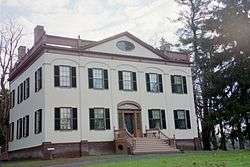 Lorenzo |
February 18, 1971 (#71000541) |
Ledyard St. (U.S. 20) 42°55′23″N 75°51′56″W |
Cazenovia | |
| 12 | The Maples | November 2, 1987 (#87001876) |
2420 Nelson Rd. 42°55′19″N 75°50′08″W |
Cazenovia | ||
| 13 | Meadows Farm Complex | November 2, 1987 (#87001869) |
Rippleton Rd. 42°55′01″N 75°51′40″W |
Cazenovia | ||
| 14 | Middle Farmhouse | November 2, 1987 (#87001870) |
4875 W. Lake Rd. 42°57′29″N 75°52′58″W |
Cazenovia | ||
| 15 | Niles Farmhouse | November 2, 1987 (#87001871) |
Rippleton Rd. 42°54′45″N 75°52′08″W |
Cazenovia | ||
| 16 | Notleymere | July 15, 1991 (#91000868) |
4641 E. Lake Rd. 42°56′52″N 75°51′47″W |
Cazenovia | ||
| 17 | Old Trees | July 15, 1991 (#91000865) |
W side of Rippleton Rd. 42°54′59″N 75°52′35″W |
Cazenovia | ||
| 18 | Ormonde | July 15, 1991 (#91000866) |
Between E. Lake Rd. and Ormonde Dr. 42°57′20″N 75°51′41″W |
Cazenovia | ||
| 19 | Parker Farmhouse | November 2, 1987 (#87001872) |
3981 East Rd. 42°54′58″N 75°51′04″W |
Cazenovia | ||
| 20 | Rippleton Schoolhouse | August 6, 1998 (#98000996) |
Rippleton Rd., 15 mi. SE of Syracuse 42°55′16″N 75°51′46″W |
Cazenovia | ||
| 21 | Rolling Ridge Farm | November 2, 1987 (#87001873) |
3937 Number Nine Rd. 42°54′46″N 75°50′45″W |
Cazenovia | ||
| 22 | Shattuck House | July 15, 1991 (#91000873) |
W. Lake Rd. 42°58′16″N 75°53′04″W |
Cazenovia | ||
| 23 | Sweetland Farmhouse | November 2, 1987 (#87001874) |
Number Nine Rd. 42°54′52″N 75°50′44″W |
Cazenovia | ||
| 24 | Tall Pines | November 2, 1987 (#87001875) |
Ridge Rd. 42°57′03″N 75°51′23″W |
Cazenovia | ||
| 25 | The Hickories | July 15, 1991 (#91000870) |
47 Forman St. 42°56′04″N 75°51′37″W |
Cazenovia | ||
| 26 | Upenough | July 15, 1991 (#91000871) |
Rippleton St. 42°54′12″N 75°52′34″W |
Cazenovia | ||
| 27 | York Lodge | July 15, 1991 (#91000872) |
4448 E. Lake Rd. 42°56′21″N 75°51′29″W |
Cazenovia |
Notable people
- Edward P. Allis (1824–1889), businessman and unsuccessful candidate for Governor of Wisconsin[9]
- Edward Griffin Beckwith (1818–1881), soldier and explorer
- Anne Burrell (born September 21, 1969), chef and TV personality
- Samuel Northrup Castle (1808–1894), missionary in Hawaii, founder of Castle & Cooke
- Sarah Brown Ingersoll Cooper, philanthropist and educator
- John W. Dwinelle (1816–1888), Lawyer and Politician in California
- Jane Calkins Egan (1917–2009), American Artist, created box assemblages.[10]
- Harrison Stiles Fairchild (1820–1901), was a Brigadier general in the Union Army
- Siobhan Fallon (born May 13, 1961), Actress
- Beezie Madden (born November 20, 1963), Olympic Equestrian Gold Medalist
- Charles Stebbins (1789–1873), Acting Lieutenant Governor of New York in 1829, buried at Evergreen Cemetery
- Steve Suhey (1922–1977), football player at Penn State and in the NFL
- Ezra Greenleaf Weld (1801–1874), (also known as "Greenleaf"), photographer and abolitionist
- Lauren McLean, Boise, Idaho politician (raised in Cazenovia)
- Gary Edward Dick Jr., Washington, DC USAF Officer (raised in Cazenovia)
- Senator Shawn Davis (raised in Cazenovia)
Economy
- Caz Equipment Company has its headquarters in Cazenovia.
- GHD Group also has one of its headquarters in Cazenovia.
- Marquardt Group also has one of its headquarters in Cazenovia.
Gallery
 F.H.M Laughlin building
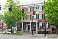 Lincklaen_House
References
- "2016 U.S. Gazetteer Files". United States Census Bureau. Retrieved Jul 5, 2017.
- "Population and Housing Unit Estimates". Retrieved June 9, 2017.
- "U.S. Census website". United States Census Bureau. Retrieved 2011-05-14.
- "Census of Population and Housing". Census.gov. Retrieved June 4, 2015.
- "U.S. Census website". United States Census Bureau. Retrieved 2008-01-31.
- "National Register Information System". National Register of Historic Places. National Park Service. March 13, 2009.
- Numbers represent an ordering by significant words. Various colorings, defined here, differentiate National Historic Landmarks and historic districts from other NRHP buildings, structures, sites or objects.
- The eight-digit number below each date is the number assigned to each location in the National Register Information System database, which can be viewed by clicking the number.
- Who Was Who in America, Historical Volume, 1607-1896. Chicago: Marquis Who's Who. 1963.
- "Jane Calkins Egan Obituary". Syracuse (NY) Post-Standard. December 20, 2009. Retrieved 2014-02-14.
External links
| Wikivoyage has a travel guide for Cazenovia. |
| Wikimedia Commons has media related to Cazenovia, New York. |
- Town of Cazenovia, NY
- Village of Cazenovia, NY
- Cazenovia NY Central Schools
- Cazenovia NY Chamber of Commerce
- Cazenovia College
- Early history of Cazenovia
Municipalities and communities of Madison County, New York, United States | ||
|---|---|---|
| City | 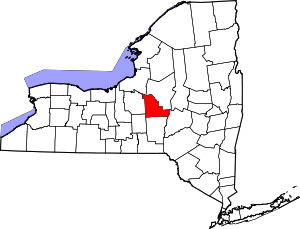 | |
| Towns |
| |
| Villages | ||
| CDP | ||
| Other hamlets | ||
| Indian reservations |
| |
| Footnotes | ‡This populated place also has portions in another county or counties | |
| Authority control |
|
|---|