Carhoo Lower
Carhoo Lower (from Irish An Cheathrú Íochtarach) is a townland within the civil parish of Magourney and catholic parish of Aghabullogue, County Cork, Ireland. It is 284.5 acres in size, and west of Coachford village.
Carhoo Lower | |
|---|---|
| Irish transcription(s) | |
| • Derivation: | An Cheathrú Íochtarach |
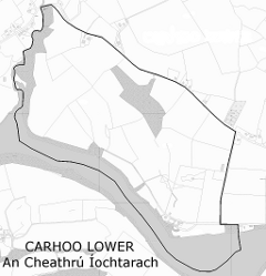 | |
 Carhoo Lower Carhoo Lower shown within Ireland | |
| Coordinates: 51°54′34″N 8°49′2″W | |
| Irish grid ref | W438733 |
| Country | Ireland |
| County | County Cork |
| Barony | Muskerry East |
| Civil parish | Magourney |
| First recorded | c. 1590 |
| Settlements | Coachford |
| Government | |
| • Council | Cork County Council |
| • Ward | Blarney-Macroom EA |
| Area | |
| • Total | 115.14 ha (284.5 acres) |
Carhoo firstly appears c. 1590 as 'Carown' in a sketch map The description of Muskery, retained as part of the Dartmouth Map Collection, at the National Maritime Museum, Greenwich.[1] In the Down Survey Maps (1656-8), it is referred to as 'Carrow' [2] and 'Carrooe', and the accompanying terrier lists Thomas and Edmund Coppinger as proprietors by way of mortgage.[3] The Ordnance Survey name book (c. 1840) describes Carhoo Lower as bounded on the north and east by Carhoo Upper and Leemount townlands, with a large portion being the Carhue demesne and the remainder mainly pasture. Various name versions are given, such as 'Carhoo' and 'Carhue', and an Irish version as Ceathramha (meaning quarter). O'Murchú (1991) holds Ceathrú as meaning a quarter, in this instance a measurement of land, such as a townland or ploughland, and being a smaller division than a tuath or triocha céad.[4] The Placenames Database of Ireland gives the townland an Irish name of An Cheathrú Íochtarach, with Ceathrú meaning a quarterland.[5]
At the south-east end of the townland, is said to exist Poul Leather, a hollow within the River Lee, renowned for both its depth and treacherous current.[6]
Townlands vary greatly in size, being territorial divisions within parishes in Ireland. Extensively used for land surveys, censuses and polling systems since the seventeenth century, townlands have also been used as the basis for rural postal addresses. In County Cork, surveying and standardisation of townland names and boundaries by the Ordnance Survey during the mid-nineteenth century, resulted in some earlier townland names disappearing, due to amalgamation or division. The townlands resulting from such surveys were employed during the Primary Land Valuation (Griffith's Valuation), subsequent censuses, and continue in use today.
|
|
|
Townland sites/items of interest
References
- "The description of Muskery, Dartmouth map collection, Royal Museums Greenwich". Retrieved 24 February 2014.
- "Down Survey map 1656-8 (Barony of Muskery)". Retrieved 5 March 2014.
- "Down Survey map 1656-8 (Ahabollog and Aghinagh)". Retrieved 5 March 2014.
- O'Murchú, M. (Dec 1991). "Place names of the parish of Aghabullogue". Coachford Record. 2.
- "Placenames Database of Ireland". Archived from the original on 28 February 2014. Retrieved 22 February 2014.
- Lankford, Eamon (2008). A Collection of Placenames from Cork County: Barony of East Muskerry. Cork Place Names Archive.
- Histpop; Area, population and number of houses, Vol. II, Ireland, 1881, page 207
- HistPop; Area, houses, and population, Munster, Ireland,1911 Page 94
- "Grand Jury map of County Cork" (PDF). Retrieved 24 February 2014.