California State Route 283
State Route 283 (SR 283) is an unsigned state highway in the U.S. state of California that is part of both US 101 Business and Wildwood Avenue through Rio Dell in Humboldt County. The SR 283 designation runs from U.S. Route 101 (US 101) south of the city near Scotia to the north end of the Eel River Bridge. US 101 Bus./Wildwood Avenue then continue north through the center of Rio Dell to meet with US 101 in the northern part of the city. The route was defined in 1970 as a transfer from a realigned US 101 after a freeway bypass was built.
| ||||
|---|---|---|---|---|
| Wildwood Avenue Part of US 101 Bus. | ||||
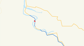 SR 283 highlighted in red | ||||
| Route information | ||||
| Defined by Streets and Highways Code § 583 | ||||
| Maintained by Caltrans | ||||
| Length | 0.356 mi[1] (0.573 km) | |||
| Existed | 1970 (from US 101)[2]–present | |||
| Major junctions | ||||
| South end | ||||
| North end | ||||
| Location | ||||
| Counties | Humboldt | |||
| Highway system | ||||
| ||||

Route description
State Route 283 spurs out of US 101 near Scotia, south of Rio Dell, while carrying US 101 Business from that intersection to the Eel River Bridge. After crossing the bridge, SR 283 ends and US 101 Business continues north through the center of Rio Dell.
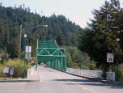
SR 283 includes the length of the Eel River Bridge, keeping its maintenance to Caltrans. The bridge itself was built in 1941, when U.S. Route 101 ran through what was then known as Eagle Prairie. In 1977, the bridge was renamed the Albert Stanwood Murphy Memorial Bridge, in honor of the Pacific Lumber Company president who assisted the Save the Redwoods League. In 1990, the bridge was given a second name, the Eagle Prairie Bridge, in honor of the 50th anniversary of the bridge's construction and the 25th anniversary of Rio Dell's incorporation.[3]
SR 283 is not part of the National Highway System,[4] a network of highways that are considered essential to the country's economy, defense, and mobility by the Federal Highway Administration.[5]
Major intersections
Except where prefixed with a letter, postmiles were measured on the road as it was when the route was established, based on the alignment that existed at the time, and do not necessarily reflect current mileage. R reflects a realignment in the route since then, M indicates a second realignment, L refers an overlap due to a correction or change, and T indicates postmiles classified as temporary (for a full list of prefixes, see the list of postmile definitions).[1] Segments that remain unconstructed or have been relinquished to local control may be omitted. The entire route is in Humboldt County.
| Location | Postmile [1][6][7] | Destinations | Notes | ||
|---|---|---|---|---|---|
| | 0.00 | Interchange; south end of US 101 Bus. overlap; US 101 exit 679 | |||
| | | Scotia | former US 101 south | ||
| Rio Dell | 0.12 | Eel River Bridge over Eel River | |||
| 0.36 | Wildwood Avenue - Rio Dell | North end of US 101 Bus. overlap; north end of SR 283 | |||
1.000 mi = 1.609 km; 1.000 km = 0.621 mi
| |||||
See also

References
- California Department of Transportation. "State Truck Route List". Sacramento: California Department of Transportation. Archived from the original (XLS file) on June 30, 2015. Retrieved June 30, 2015.
- California Highways: Unsigned State Route 283
- California Highways Routes 281 through 288
- Federal Highway Administration (March 25, 2015). National Highway System: California (North) (PDF) (Map). Scale not given. Washington, DC: Federal Highway Administration. Retrieved July 30, 2017.
- Natzke, Stefan; Neathery, Mike & Adderly, Kevin (June 20, 2012). "What is the National Highway System?". National Highway System. Washington, DC: Federal Highway Administration. Retrieved July 1, 2012.
- California Department of Transportation (July 2007). "Log of Bridges on State Highways". Sacramento: California Department of Transportation.
- California Department of Transportation, All Traffic Volumes on CSHS, 2005 and 2006
External links
| Wikimedia Commons has media related to California State Route 283. |