California State Route 220
State Route 220 (SR 220) is a state highway in the U.S. state of California, defined to run between State Route 84 and State Route 160 on Ryer Island in the Sacramento–San Joaquin River Delta. At the eastern end of Ryer Island, the road crosses Steamboat Slough on the Howard Landing Ferry, a cable ferry.
| ||||
|---|---|---|---|---|
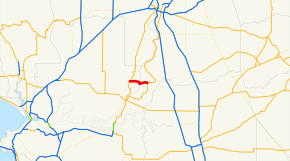 SR 220 highlighted in red | ||||
| Route information | ||||
| Defined by Streets and Highways Code § 520 | ||||
| Maintained by Caltrans | ||||
| Length | 6 mi[1] (10 km) | |||
| Restrictions | No tractor-trailers or vehicles over 15 tons on the Howard Landing Ferry. Length restrictions may also apply.[2] | |||
| Major junctions | ||||
| West end | ||||
| East end | ||||
| Location | ||||
| Counties | Solano, Sacramento | |||
| Highway system | ||||
| ||||

Route description
The route begins at State Route 84 in Solano County. It then heads eastward and follows the Howard Landing Ferry across the Steamboat Slough to its east end at State Route 160 in Sacramento County.
SR 220 is not part of the National Highway System,[3] a network of highways that are considered essential to the country's economy, defense, and mobility by the Federal Highway Administration.[4]
Major intersections
Except where prefixed with a letter, postmiles were measured on the road as it was in 1964, based on the alignment that existed at the time, and do not necessarily reflect current mileage. R reflects a realignment in the route since then, M indicates a second realignment, L refers an overlap due to a correction or change, and T indicates postmiles classified as temporary (for a full list of prefixes, see the list of postmile definitions).[5] Segments that remain unconstructed or have been relinquished to local control may be omitted. The numbers reset at county lines; the start and end postmiles in each county are given in the county column.
| County | Location | Postmile [5][1][6] | Destinations | Notes | |
|---|---|---|---|---|---|
| Solano SOL 0.00-3.20 | | 0.00 | West end of SR 220 | ||
| Solano–Sacramento county line | | 3.20 | |||
| Sacramento SAC 0.00-3.10 | Ryde | 3.10 | East end of SR 220 | ||
| 1.000 mi = 1.609 km; 1.000 km = 0.621 mi | |||||
See also

References
- California Department of Transportation (April 2008). "Log of Bridges on State Highways". Sacramento: California Department of Transportation.
- "Special Route Restrictions". Caltrans. Retrieved 2014-07-28.
- Federal Highway Administration (March 25, 2015). National Highway System: California (South) (PDF) (Map). Scale not given. Washington, DC: Federal Highway Administration. Retrieved September 9, 2017.
- Natzke, Stefan; Neathery, Mike & Adderly, Kevin (June 20, 2012). "What is the National Highway System?". National Highway System. Washington, DC: Federal Highway Administration. Retrieved July 1, 2012.
- California Department of Transportation. "State Truck Route List". Sacramento: California Department of Transportation. Archived from the original (XLS file) on June 30, 2015. Retrieved June 30, 2015.
- California Department of Transportation, All Traffic Volumes on CSHS, 2007
External links
| Wikimedia Commons has media related to California State Route 220. |