California State Route 217
State Route 217 (SR 217) is a state highway in the U.S. state of California that serves as a spur route from U.S. Route 101 to the University of California, Santa Barbara. Although the entire route is a freeway, SR 217 is officially named Ward Memorial Boulevard in honor of California State Senator Clarence C. Ward, who represented Santa Barbara County from 1941 to 1955.[2]
| ||||
|---|---|---|---|---|
| Ward Memorial Boulevard | ||||
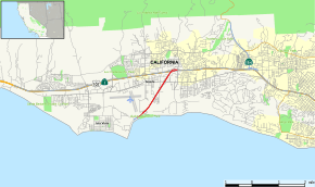 Map of Santa Barbara County in southern California with SR 217 highlighted in red | ||||
| Route information | ||||
| Defined by Streets and Highways Code § 517 | ||||
| Maintained by Caltrans | ||||
| Length | 2.525 mi[1] (4.064 km) | |||
| Major junctions | ||||
| West end | UC Santa Barbara | |||
| East end | ||||
| Location | ||||
| Counties | Santa Barbara | |||
| Highway system | ||||
| ||||

Route description
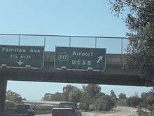
It connects the University of California, Santa Barbara and the Santa Barbara Municipal Airport with U.S. Route 101, which is the major highway that connects Santa Barbara with other major cities along California's Pacific Coast. State Route 217 can be found about 6 miles (9.7 km) west of Central Santa Barbara. It is a freeway for its entire length.
SR 217 is part of the National Highway System,[3] a network of highways that are considered essential to the country's economy, defense, and mobility by the Federal Highway Administration.[4]
Exit list
Except where prefixed with a letter, postmiles were measured on the road as it was in 1964, based on the alignment that existed at the time, and do not necessarily reflect current mileage. R reflects a realignment in the route since then, M indicates a second realignment, L refers an overlap due to a correction or change, and T indicates postmiles classified as temporary (for a full list of prefixes, see the list of postmile definitions).[1] Segments that remain unconstructed or have been relinquished to local control may be omitted. The entire route is in Santa Barbara County.
| Location | Postmile [1][5][6] | Exit [7] | Destinations | Notes | |
|---|---|---|---|---|---|
| Isla Vista | 0.46 | University of California, Santa Barbara | West end of SR 217 | ||
| | 0.93 | 1 | Serves Santa Barbara Airport | ||
| Goleta | 2.23 | 2 | Hollister Avenue | ||
| 2.76 | 3 | Eastbound exit and westbound entrance | |||
| 2.76 | East end of SR 217; US 101 exit 104B | ||||
| 1.000 mi = 1.609 km; 1.000 km = 0.621 mi | |||||
See also

References
- California Department of Transportation. "State Truck Route List". Sacramento: California Department of Transportation. Archived from the original (XLS file) on June 30, 2015. Retrieved June 30, 2015.
- California Department of Transportation; California State Transportation Agency (January 2015). 2014 Named Freeways, Highways, Structures and Other Appurtenances in California. Sacramento: California Department of Transportation. pp. 75, 278. Archived from the original (PDF) on May 30, 2015. Retrieved May 30, 2015.
- Federal Highway Administration (March 25, 2015). National Highway System: Santa Barbara, CA (PDF) (Map). Scale not given. Washington, DC: Federal Highway Administration. Retrieved September 9, 2017.
- Natzke, Stefan; Neathery, Mike & Adderly, Kevin (June 20, 2012). "What is the National Highway System?". National Highway System. Washington, DC: Federal Highway Administration. Retrieved July 1, 2012.
- California Department of Transportation (July 2007). "Log of Bridges on State Highways". Sacramento: California Department of Transportation.
- California Department of Transportation, All Traffic Volumes on CSHS, 2005 and 2006
- California Department of Transportation, California Numbered Exit Uniform System, SR-217 Eastbound and SR-217 Westbound, accessed February 2008
External links
| Wikimedia Commons has media related to California State Route 217. |