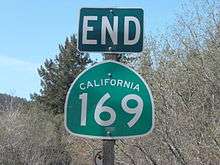
California State Route 169
State Route 169 (SR 169) is a state highway in the U.S. state of California that is separated into two distinct segments by undeveloped areas in the Yurok Indian Reservation in Del Norte and Humboldt counties. The western segment runs from U.S. Route 101 near Klamath to Klamath Glen, while the eastern segment goes from Wauteck Village to State Route 96 near Weitchpec.
| ||||
|---|---|---|---|---|
 Map of northwestern California with SR 169 highlighted in red | ||||
| Route information | ||||
| Defined by Streets and Highways Code § 469 | ||||
| Maintained by Caltrans | ||||
| Length | 23.867 mi[1] (38.410 km) SR 169 is broken into pieces due to an unconstructed portion, and the length does not reflect the gap. | |||
| Existed | 1919–present | |||
| Section 1 | ||||
| West end | ||||
| East end | Klamath Glen | |||
| Section 2 | ||||
| West end | Wauteck Village | |||
| East end | ||||
| Location | ||||
| Counties | Del Norte, Humboldt | |||
| Highway system | ||||
| ||||

Route description
The route begins at U.S. Route 101 near Klamath and after a discontinuity from Klamath Glen (near the McBeth Airport) to Johnsons via the Yurok Indian Reservation, resumes at the town of Wautec. The highway continues through Pecwan before the curving road heads southeast and passes through Martins Ferry after several miles. SR 169 ends at State Route 96 near Weitchpec. The entire route is within the Yurok Indian Reservation.[2]
SR 169 is not part of the National Highway System,[3] a network of highways that are considered essential to the country's economy, defense, and mobility by the Federal Highway Administration.[4]
Major intersections
Except where prefixed with a letter, postmiles were measured on the road as it was in 1964, based on the alignment that existed at the time, and do not necessarily reflect current mileage. R reflects a realignment in the route since then, M indicates a second realignment, L refers an overlap due to a correction or change, and T indicates postmiles classified as temporary (for a full list of prefixes, see the list of postmile definitions).[1] Segments that remain unconstructed or have been relinquished to local control may be omitted. The numbers reset at county lines; the start and end postmiles in each county are given in the county column.
| County | Location | Postmile [1][5][6] | Destinations | Notes | |||
|---|---|---|---|---|---|---|---|
| Del Norte DN R0.00-3.52 | Klamath | R0.00 | Interchange; west end of SR 169 | ||||
| Klamath Glen | 3.52 | Riffle Road | |||||
| Gap in route | |||||||
| Humboldt HUM 13.20-33.84 | Wauteck Village | 13.20 | Wauteck Village | ||||
| | 29.95 | Martins Ferry Bridge over Martins Ferry School Creek | |||||
| Weitchpec | 33.84 | East end of SR 169 | |||||
| 1.000 mi = 1.609 km; 1.000 km = 0.621 mi | |||||||
See also

References
- California Department of Transportation. "State Truck Route List". Sacramento: California Department of Transportation. Archived from the original (XLS file) on June 30, 2015. Retrieved June 30, 2015.
- California Road Atlas (Map). Thomas Brothers. 2008.
- Federal Highway Administration (March 25, 2015). National Highway System: California (North) (PDF) (Map). Scale not given. Washington, DC: Federal Highway Administration. Retrieved September 17, 2017.
- Natzke, Stefan; Neathery, Mike & Adderly, Kevin (June 20, 2012). "What is the National Highway System?". National Highway System. Washington, DC: Federal Highway Administration. Retrieved July 1, 2012.
- California Department of Transportation (July 2007). "Log of Bridges on State Highways". Sacramento: California Department of Transportation.
- California Department of Transportation, All Traffic Volumes on CSHS, 2005 and 2006
External links
| Wikimedia Commons has media related to California State Route 169. |