Cairo Ohio River Bridge
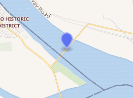
The Cairo Ohio River Bridge is a cantilever bridge carrying U.S. Route 51, U.S. Route 60, and U.S. Route 62[1] across the Ohio River between Wickliffe, Kentucky[1] and Cairo, Illinois. Of all the Ohio River crossings, it is the furthest downstream; the Mississippi River can be seen while crossing the bridge and looking westward.
Cairo Ohio River Bridge | |
|---|---|
 | |
| Coordinates | 36.9935°N 89.1462°W |
| Carries | 2 lanes of |
| Crosses | Ohio River |
| Locale | Wickliffe, Kentucky and Cairo, Illinois |
| Maintained by | Kentucky Transportation Cabinet |
| Characteristics | |
| Design | Cantilever bridge |
| Total length | 5,863.7 feet (1,787.3 m) |
| Width | 20 feet (6.1 m) |
| Longest span | 800 feet (240 m) |
| Clearance above | 19.6 feet (6.0 m) |
| History | |
| Opened | 1937 |
| |
This is an authorized truck route.
History
Construction was awarded to Modjeski and Masters and the Mt. Vernon Bridge Co.[2] It was finished in 1937 and rehabilitated in 1979. Today the Cairo Ohio River Bridge is eligible for listing on the National Register of Historic Places.[2]
See also
External links
| Wikimedia Commons has media related to Cairo Ohio River Bridge. |
- Cairo Ohio River Bridge (US 51, US 60, US 62) at Bridges & Tunnels
 At sunset
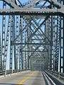 Steel framing
.JPG) Eastern spans
Eastern spans
Bridges of the Ohio River | ||||
|---|---|---|---|---|
| ||||
References
- Missourian, Southeastern. "Ohio River bridge between Cairo, Wickliffe reopens". Southeast Missourian. Retrieved 3 September 2012.
- "Cairo Ohio River Bridge". Bridgehunter.com. Retrieved 3 September 2012.
This article is issued from Wikipedia. The text is licensed under Creative Commons - Attribution - Sharealike. Additional terms may apply for the media files.