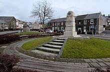
Caerau, Bridgend
Caerau (English: Forts) is an electoral ward, village and former mining village in South Wales, Wales, located approximately 2 miles north of Maesteg in the Llynfi Valley, and is part of the Bridgend County Borough (Welsh: Bwrdeistref Sirol Penybont ar Ogwr). Caerau, surrounded by mountainous terrain and forestry, is one of the border points between Bridgend County Borough and Neath Port Talbot County Borough, bordered to the north by Croeserw and Cymmer, Neath Port Talbot. Caerau, borders Dyffryn and Spelter to the south in Nantyffyllon, Maesteg, Bridgend (Welsh: Penybont ar Ogwr).
Governance
| Level | Body | Constituency or Ward | Representatives (Current) |
|---|---|---|---|
| Community | Maesteg Town Council | Caerau Ward, Local |
Cllr. Paul Davies |
| County | Bridgend County Borough Council | Caerau Ward, County |
Cllr. Paul Davies |
| Wales | Welsh Parliament | Ogwr constituency | Huw Irranca-Davies, AM[3] |
| UK | UK Parliament | Ogmore constituency | Chris Elmore, MP[4] |
| EU (former) | EU Parliament | Wales constituency | N/A |
History
Caerau is a village which was given the opportunity to expand and develop as a result of the areas rich connection with coal mining, likewise to many other valleys in the South Wales' coalfield areas. During World War 2, Caerau played a big part of ensuring the nation was prepared for the eventualities of war through both coal mining and the acceptance of children evacuees from neighbouring England. Caerau hosted a large amount of children during this period as part of the evacuation process. During this period, Caerau still had a significant connection with the Welsh language. Children moving to the area generally found that people could speak English, although there was significant dialectal and colloquial differences adopted to their speech from the Welsh language. Moreover, the older population would predominantly speak Welsh the majority of the time.[5]
History of Caerau Colliery
The village grew rapidly after the opening of Caerau Colliery in 1889 by North's Navigation Collieries. In brief, the colliery consisted of three shafts (North, South and No. 3 Pits) and employed 2,400 men at its peak in the early 1920s. The mine closed in 1977.
The Inspector of Mines list, 1896, shows there were 533 men employed in Caerau "South Pit" producing steam coal. Further development saw the sinking of No.3 House Coal Pit in 1903. In 1908, there were 1,170 men employed in the two Steam Coal Pits and 57 in the House Coal Pit. This colliery held the record output for the South Wales area in 1913. By 1918, the workforce had risen to 1,839.
From a list drafted in 1923, there were 2,040 employed at the Steam Coal Pits, producing coal and ironstone from the Six Feet, Seven Feet and Upper and Lower New Seams. The House Coal Pit employed 340 men, producing from the Two and a Half Feet Seam. The House Coal Pit closed in 1925.
Three men were killed in an underground accident at Caerau Colliery in 1931. By the end of the war in 1945, there were 568 men still in employment.[6]
Production began to slow from 1977. During its final two years, coal production concentrated on the Bute Seam. Caerau Colliery eventually closed permanently in 1979, five years before Margaret Thatcher's announcement of coal pit closures in 1984 which led to the miners' strike of 1984 and 1985. Most of the men were transferred to nearby Coegnant and St. John's Colliery.
Caerau Colliery Legacy
As part of an ongoing effort to preserve the legacy of Caerau Colliery, a new scheme[7] has been announced which aims to pump naturally heated water, at about 20.6° Celsius, from a depth of 230 metres in the old Caerau Colliery mine, to the surface above. Initially protected to cost £6.5 million,[8] it is now estimated the funding will be around £9.4 million,[9] the warm water will be fed through a heat exchanger unit. This is a device that will be fitted in people's homes and is roughly the size of a refrigerator. The hot air will then be passed through a heat pump which in turn warms the water used in the home's central heating system. The water from the mine will not enter the home's central heating but will be pumped back underground so it can heat back up naturally and be reused.[10]
Census
The ward population taken at the 2011 census was 6,995.[11]
Amenities and Community Projects
Caerau is home to a range of community projects. Most notably, Caerau Market Garden (Welsh: Gardd Farchnad Caerau) which is managed by Caerau Community Growers, and Noddfa Community Project, (noddfa=English: refuge, sanctuary and/or shelter), at Noddfa Community Centre. Both have had significant success in recent years. Caerau Market Garden has been transformed into an awarding winning site by its members, holding multiple, consecutive Green Flag Awards on an annual basis. The site hosts a range facilities including community poly tunnels, log cabins, raised beds and many other eco friendly, state of the art facilities.
Village, Churches and Facilities
Caerau once had six churches. Many of these are in a state of disrepair, but St Cynfelyn Church is still in regular use.[12] Caerau also once had two cinemas called the "Coliseum", which was demolished in the 1970s. The high street is now home to a number of local convenience stores, a credit union, a sports betting shop, chemist, public houses and a range of takeaway houses. However, it once housed many other retailers, hairdressers, a cinema and familiar high-street banks.
Hotels and Public Houses
There are many public houses and hotels around Caerau. As well as the "Blaenllynfi", "The Navi" and "Station Hotel" there are also smaller establishments like the "British Legion". On the outskirts of Caerau, "The Blaencaerau Hotel" was renovated in the 1980s and renamed "The Monkey Inn". Unfortunately, the hotel was destroyed by arson soon after closure in 1990.
Education
Caerau hosts a Primary School for children aged 3 to 11. Historically, children were educated across two sites with the infants being taught at Blaenllynfi Infants School at Grosvenor Terrace and the juniors being educated at Blaencaerau Primary School on Blaencaerau Road. The old junior school was over 100 years old when it was closed. It was later destroyed by arson while the brand new Caerau Primary was being built. With both schools now amalgamated into one, the new Caerau Primary School is a state-of-the-art Eco-Building constructed from eco-friendly materials. The building has a complex ultra-high-efficiency heating system. Education at Caerau Primary School is predominantly focused around English-medium with the inclusion of Welsh-medium as a bilingual focus across all ages. Primary school children whose parents opt for Welsh-medium education attend Ysgol Gynradd Gymraeg Cynwydd Sant, Maesteg. Secondary school education takes place at Maesteg Comprehensive School for English-medium students and Ysgol Gyfun Gymraeg Llangynwyd for Welsh-medium students.
Transport
The village is located on the A4063 road between Croeserw and Maesteg. There are a number of taxi firms which operate in the area. The village has a regular bus link to connect with the Maesteg Railway at Maesteg Railway Station. Additionally, bus route 70 and 71 will connect Caerau directly with Bridgend town centre, via Maesteg town centre and vice versa. The village used to have its own railway station but this infrastructure has since been removed.
Sport
Caerau FC, the local football club, play in the 1st division of the South Wales Amateur League (as of 2008-09). They play at the Athletic Ground at Humphreys Terrace, which is a south of the village centre.
Caerau also hosts a national-standard BMX track, home to the Llynfi BMX Racing Club, behind The Duffryn Pub on Coegnant Road. There is also a Clubhouse for the Bowling Green at Caerau Park.
References
- "Caerau Ward". Maesteg Town Council. Retrieved 9 February 2020.
- "Your Councillors". Bridgend County Borough Council. Retrieved 9 February 2020.
- "Assembly Member Profile". Welsh Parliament. Retrieved 9 February 2020.
- "MPs and Lords". UK Parliament. Retrieved 9 February 2020.
- "Evacuation to Caerau". BBC. Retrieved 9 February 2020.
- "Caerau Colliery". Welsh Coal Mines. Retrieved 9 February 2020.
- "£6.5m for Caerau". BBC. Retrieved 9 February 2020.
- "Caerau Mine Watrer Project". Wales Online. Retrieved 9 February 2020.
- "EU boost for £9.4m project". Welsh Government. Retrieved 9 February 2020.
- "From Black to Green". Jordan's Solicitors. Retrieved 9 February 2020.
- "Wales Census Ward Population 2011". UK Census Data. Retrieved 9 February 2019.
- "The Parish of Caerau St Cynfelyn". Retrieved 9 February 2020.
| Communities | 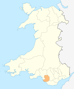 | |
|---|---|---|
| Towns and villages |
| |
| Castles | ||
| Rivers | ||
| Topics | ||