Tietê River
The Tietê River (Portuguese, Rio Tietê, Portuguese pronunciation: [tʃi.e'te])[3] is a Brazilian river in the state of São Paulo.
| Tietê River | |
|---|---|
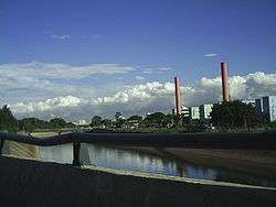
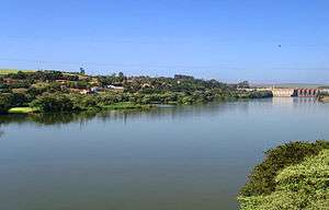 Tietê River at Barra Bonita and Igaraçu do Tietê | |
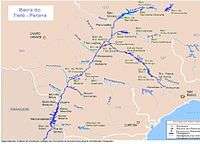
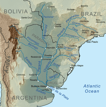 Map of the La Plata Basin, showing the Tietê River flowing from São Paulo to the Paraná River. | |
| Native name | Rio Tietê |
| Location | |
| Country | Brazil |
| Region | South America |
| Physical characteristics | |
| Source | Salesópolis, Serra do Mar |
| • elevation | 1,120 m (3,670 ft) |
| Mouth | Lake at the Eng Souza Dias (Jupiá) Dam, Paraná River |
• elevation | 280.5 m (920 ft) |
| Length | 1,150 km (710 mi) |
| Basin size | 150,000 km2 (58,000 sq mi) |
| Discharge | |
| • average | 2,500 m3/s (88,000 cu ft/s)[1][2] |
The name Tietê was registered for the first time on a map published in 1748 by d’Anville.[4] The name signifies "The truthful river", or "truthful waters” in Tupi.
Source
The river starts in the Serra do Mar, to the east of São Paulo city.[5]
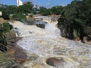
Ihe municipality of Salesópolis, it encounters one of the first hydroelectric power stations constructed in Brazil, "Usina Parque de Salesópolis", constructed in 1912 by the old São Paulo Tramway, Light and Power Company. It generated energy from an artificial waterfall with a height of 72 m of the river.
Navigation on the waterway Tietê-Paraná
In several dams, for instance, the Barra Bonita, systems of locks were implemented to make navigation on the river possible. Many barges transport produce of the region at a cost which is lower than road transport. The waterway of the Tietê-Paraná permits navigation over a length of 1,100 kilometres (680 mi) between Conchas on the River Tietê (São Paulo) and São Simão (Goiás), on the Paranaíba River and then, up to ltaipu, attaining 2,400 kilometres (1,500 mi) of waterway. It already moves more than one million metric tons of grains (maize) per year, at an average distance of 700 kilometres (430 mi). If we calculate the loads with a small distance like sand, gravel, and sugarcane, the movement on the River Tietê is approximately 2 million metric tons. (source : DNIT) Of this waterway, about 450 kilometres (280 mi) of the Tietê River is fully navigable[6][7]
Pollution and environmental degradation

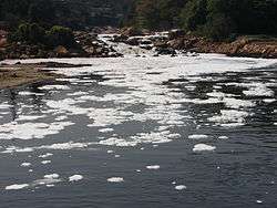
Although the Tiete River is said to be one of the most important rivers economically for the state of São Paulo and for the country, the Tietê River is best known for its environmental problems, especially for the stretch through the city of São Paulo.
The pollution of the Tietê River did not start long ago. Even in the 1960s, the river still had fish in the stretch within the capital. However, the environmental degradation of the Tietê River started subtly in the 1920s with the construction of the Guarapiranga Reservoir, by the Canadian firm São Paulo Tramway, Light and Power Company, for the later generation of electrical energy in the hydroelectric power stations Edgar de Souza and Rasgão, situated in Santana de Parnaíba. This intervention altered the regime of the waters in the capital and was accompanied with some rectification works also by the São Paulo Tramway, Light and Power Company, which left the bed of the river less winding, in the region between Vila Maria and “Freguesia do Ó.”
Even in the 1920s and 1930s, the river was utilised for fishing and sports activities were famous as were the nautical races on the river. During this period boat race clubs were created along the length of the river, such as the Club of the Tietê races and the Espéria, clubs that exist till now.

In September 2010 National Geographic identified the river as the most polluted in Brazil.[8]
Several species from the Tietê River are considered threatened and one of these, the catfish Heptapterus multiradiatus, is possibly already extinct.[9]
The Tietê project
The governor of São Paulo ordered Sabesp, the company responsible for sanitation in the state, to establish a program to clean up the river. The state at the same time sought help at the Inter American Development Bank, and proposed a project based on the former studies of SANEGRAN.
After more than 16 years, the cleaning up of the River Tietê is still far short of desired levels, but encouraging progress has been made. At the end of the 1990s, the capacity of sewage treatment has been expanded: Sabesp has expanded the treatment capacity of the Wastewater Treatment Plant in Barueri, and the Seasons of the Sewage Treatment at San Miguel, to treat the rest of the sewage of the city of São Paulo.
Affluents of the Tietê River
- Pinheiros River
- Tamanduateí River
- Aricanduva River
- Baquirivu-Guaçu River
- Batalha River
- Bauru River
- Biritiba-Mirim River
- Capivara River
- Capivari River
- Cotia River
- Dourado River
- Jacaré-Guaçu River
- Jacaré-Pepira River
- Jaú River
- Jundiaí River
- Piracicaba River
- São Lourenço River
- Sorocaba River
References
- Chapter 4. Hydrological basins: International Development Archived 24 October 2004 at the Wayback Machine, Research Centre
- As much as ≈600 m³/s of the river discharge is diverted into Ilha Solteira Dam reservoir, the rest of Tietê discharge (≈1900 m³/s) goes into Parana through Três Irmãos Dam. This scheme allows avoid water loss related to power limitation of Três Irmãos hydro plant (880 MW).
- Rio Tietê at GEOnet Names Server
- Transportes.gov.br Ministry of transport Archived 27 July 2009 at the Wayback Machine
- "Tietê River". Encyclopaedia Britannica. Retrieved 30 July 2018.
- Transportes.gov.br Archived 27 July 2009 at the Wayback Machine, Segundo a página do Ministério dos Transportes.
- Bibliotecavirtual.sp.gov.br Archived 6 July 2011 at the Wayback Machine, Rio Tiete and navigation
- Sabrina Valle (23 September 2010). "Pictures: Toxic Foam Chokes Brazil River". National Geographic Society. Retrieved 16 September 2015.
- ICMBio (Ministry of the Environment, Brazil): Portaria MMA nº 445, de 17 de dezembro de 2014. Lista de Especies Ameaçadas – Saiba Mais. Retrieved 1 December 2018.
- GNS coordinates adjusted using Google Maps and Tools.freeside.sk, geo locator