Bushton, Kansas
Bushton is a city in Rice County, Kansas, United States. As of the 2010 census, the city population was 279.[6]
Bushton, Kansas | |
|---|---|
 Grain elevator in Bushton (2004) | |
 Location within Rice County and Kansas | |
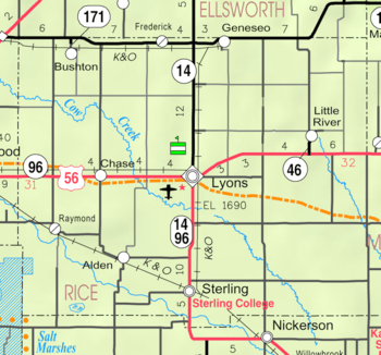 KDOT map of Rice County (legend) | |
| Coordinates: 38°30′43″N 98°23′42″W | |
| Country | United States |
| State | Kansas |
| County | Rice |
| Township | Farmer |
| Founded | 1880s |
| Incorporated | 1907 |
| Named for | wild bushes |
| Area | |
| • Total | 0.23 sq mi (0.60 km2) |
| • Land | 0.23 sq mi (0.60 km2) |
| • Water | 0 sq mi (0 km2) |
| Elevation | 1,768 ft (539 m) |
| Population | |
| • Total | 279 |
| • Estimate (2016)[3] | 271 |
| • Density | 1,200/sq mi (470/km2) |
| Time zone | UTC-6 (CST) |
| • Summer (DST) | UTC-5 (CDT) |
| ZIP code | 67427 |
| Area code | 620 |
| FIPS code | 20-09700 [4] |
| GNIS ID | 0475533 [5] |
History
Bushton was originally called Sorghum, and under the latter name established in the early 1880s. It was renamed Bushton in 1887, after a number of wild bushes growing at the town site.[7][8] Bushton was incorporated in 1907.[9]
Geography
Bushton is located at 38°30′43″N 98°23′42″W (38.511817, -98.395077).[10] According to the United States Census Bureau, the city has a total area of 0.23 square miles (0.60 km2), all of it land.[1]
Demographics
| Historical population | |||
|---|---|---|---|
| Census | Pop. | %± | |
| 1910 | 222 | — | |
| 1920 | 326 | 46.8% | |
| 1930 | 325 | −0.3% | |
| 1940 | 473 | 45.5% | |
| 1950 | 532 | 12.5% | |
| 1960 | 499 | −6.2% | |
| 1970 | 397 | −20.4% | |
| 1980 | 388 | −2.3% | |
| 1990 | 341 | −12.1% | |
| 2000 | 314 | −7.9% | |
| 2010 | 279 | −11.1% | |
| Est. 2016 | 271 | [3] | −2.9% |
| U.S. Decennial Census | |||
2010 census
As of the census[2] of 2010, there were 279 people, 117 households, and 78 families residing in the city. The population density was 1,213.0 inhabitants per square mile (468.3/km2). There were 151 housing units at an average density of 656.5 per square mile (253.5/km2). The racial makeup of the city was 92.5% White, 2.9% African American, 2.5% Native American, 0.4% from other races, and 1.8% from two or more races. Hispanic or Latino of any race were 8.2% of the population.
There were 117 households of which 23.9% had children under the age of 18 living with them, 53.0% were married couples living together, 8.5% had a female householder with no husband present, 5.1% had a male householder with no wife present, and 33.3% were non-families. 29.1% of all households were made up of individuals and 8.6% had someone living alone who was 65 years of age or older. The average household size was 2.38 and the average family size was 2.90.
The median age in the city was 42.4 years. 26.9% of residents were under the age of 18; 3.7% were between the ages of 18 and 24; 22.6% were from 25 to 44; 28.7% were from 45 to 64; and 18.3% were 65 years of age or older. The gender makeup of the city was 51.3% male and 48.7% female.
2000 census
As of the census[4] of 2000, there were 314 people, 134 households, and 95 families residing in the city. The population density was 1,510.6 people per square mile (577.3/km²). There were 158 housing units at an average density of 760.1 per square mile (290.5/km²). The racial makeup of the city was 96.82% White, 1.59% from other races, and 1.59% from two or more races. Hispanic or Latino of any race were 2.87% of the population.
There were 134 households out of which 26.9% had children under the age of 18 living with them, 60.4% were married couples living together, 7.5% had a female householder with no husband present, and 29.1% were non-families. 26.9% of all households were made up of individuals and 14.9% had someone living alone who was 65 years of age or older. The average household size was 2.34 and the average family size was 2.80.
In the city, the population was spread out with 23.9% under the age of 18, 7.0% from 18 to 24, 23.6% from 25 to 44, 25.5% from 45 to 64, and 20.1% who were 65 years of age or older. The median age was 42 years. For every 100 females, there were 79.4 males. For every 100 females age 18 and over, there were 88.2 males.
The median income for a household in the city was $37,250, and the median income for a family was $47,708. Males had a median income of $32,500 versus $18,000 for females. The per capita income for the city was $17,125. About 6.3% of families and 9.5% of the population were below the poverty line, including 14.5% of those under age 18 and 7.8% of those age 65 or over.
Education
Bushton is served by Central Plains USD 112 school district. Central Plains Middle School was located in Bushton, but closed in 2019.[11]
School unification consolidated Bushton schools into Quivira Heights schools in the 1980s. The Quivira Heights High School mascot was Thunderbirds. Quivira Heights High School closed in 2012.[12]
Bushton High School was closed through school unification. The Bushton High School mascot was Trojans.[13]
Sports
The Central Plains Oilers won the Kansas State High School 8-Man DI football championship in 2014.[14]
The Quivira Heights Thunderbirds won the Kansas State High School 8-Man DII football[14] and 1A boys basketball[15] championships in 1983.
References
- "US Gazetteer files 2010". United States Census Bureau. Archived from the original on 2012-01-25. Retrieved 2012-07-06.
- "U.S. Census website". United States Census Bureau. Retrieved 2012-07-06.
- "Population and Housing Unit Estimates". Retrieved June 9, 2017.
- "U.S. Census website". United States Census Bureau. Retrieved 2008-01-31.
- "US Board on Geographic Names". United States Geological Survey. 2007-10-25. Retrieved 2008-01-31.
- "2010 City Population and Housing Occupancy Status". U.S. Census Bureau. Retrieved September 26, 2011.
- Kansas State Historical Society (1916). Biennial Report of the Board of Directors of the Kansas State Historical Society. Kansas State Printing Plant. pp. 273.
- "Profile for Bushton, Kansas". ePodunk. Retrieved 22 June 2014.
- Blackmar, Frank Wilson (1912). Kansas: A Cyclopedia of State History, Embracing Events, Institutions, Industries, Counties, Cities, Towns, Prominent Persons, Etc. Standard Publishing Company. pp. 260.
- "US Gazetteer files: 2010, 2000, and 1990". United States Census Bureau. 2011-02-12. Retrieved 2011-04-23.
- Central Plains school district closing middle school; KWCH; June 11, 2019.
- "Quivira Heights High School". Public School Review. Retrieved 3 January 2017.
- "Holyrood unable to stop consistent Bushton rush", Great Bend Tribune, 20 October 1974, p.21.
- "Football". KSHSAA. Retrieved 3 January 2017.
- "Basketball". KSHSAA. Retrieved 3 January 2017.
Further reading
External links
| Wikimedia Commons has media related to Bushton, Kansas. |
- City
- Maps
- Bushton City Map, KDOT
Municipalities and communities of Rice County, Kansas, United States | ||
|---|---|---|
| Cities | 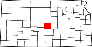 Map of Kansas highlighting Rice County | |
| Unincorporated communities | ||
| Townships | ||