Burrill with Cowling
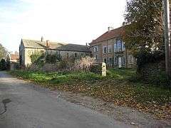
Burrill with Cowling is a civil parish in the Hambleton District of North Yorkshire, England, including the villages of Burrill and Cowling. It is only a 5-minute walk between the 2 small villages and lies west of Bedale by 1 mile. According to the 2011 census it had a population of 104 with 50 households in total. It is a small parish surrounded by sparsely populated countryside, containing mainly detached and semi-detached houses.[2] The closest city is Ripon which is located 17 miles (27 km) away while being approximately 4 hours (234 miles) away from London. Burrill with Cowling is most accessible by the A1, which runs 3.1 miles east of Burrill with Cowling with the nearest railway station being 15 miles away in Northallerton.
| Burrill with Cowling | |
|---|---|
 Burrill with Cowling Location within North Yorkshire | |
| Population | 104 (2011 census)[1] |
| OS grid reference | SE2408887120 |
| Civil parish |
|
| District | |
| Shire county | |
| Region | |
| Country | England |
| Sovereign state | United Kingdom |
| Post town | Bedale |
| Postcode district | DL8 |
| Police | North Yorkshire |
| Fire | North Yorkshire |
| Ambulance | Yorkshire |
| UK Parliament |
|
In 1870/72. John Marius Wilson described Burrill with Cowling as:
- "A township in Bedale parish, N. R. Yorkshire; 1¾ mile SW of Bedale. It has a post office, of the name of Burrell, under Bedale. Acres, 463. Real property, £1,415. Pop., 111. Houses, 25."[3]
Demographics
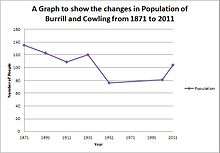
According to the 2011 census Burrill with Cowling is a small parish with a population of 104 and only 50 households.[1] The average age of the population is 47.6 showing a mainly working age population in the parish, coupled with the highest percentage of the population (33.7%) being in the 45–59 age range. The second biggest age group is 60+ which contains 32 people (30.1%), which mirrors the ageing population in the country, with the smallest age group being 15- to 19-year-olds at only 3 people out of 104 in the whole of Burrill with Cowling.[1] Although the population has fluctuated slightly, there has been little change since 1881, where the population was 100[4] compared with 104 as of 2011.
Economy and industry
In the 1800s Burrill with Cowling's main industry was agriculture, with 25 people out of the total population working in the farming trade in 1881.[5] Agriculture is still the main industry as it accounts for 16.1% of all industry (10 people employed in this sector) with manufacturing being the second largest employer with 8 people employed while the two smallest industrial sectors are 'Financial and Insurance Activities' and 'Information and Communication' both with 1.6% of the total number of employed.[6] As of 2011 there were 84 people of working age with 60 of these being economically active, 2 being students and a further 14 being retired.[1]
Listed buildings
Burrill with Cowling is home to a handful of listed buildings; Ivy Cottage (Grade II listed on 22 August 1966),[7] Manor House (Grade II listed on 5 May 1952)[8] and most notably Cowling Hall. Cowling Hall is a Grade I listed building (22 August 1966) located on Cowling Lane, Burrill, DL8 1RR.[9] The Hall is currently owned by the village and is run by a group of volunteers whilst being entirely self-funded with the hall being opened on 1 December 2012 to be used by various members of the community for classes, youth clubs and social groups.[10] It was in 1985 that the land the Hall now stands on was purchased with the aim to build 'The Cowling Liberal Club and Institute' which contained a Reading Room and Library and was used for political and social gatherings, it went through many changes since opening – mainly housing the 'Cowling Women's' Liberal Association'. In 1939 membership of the club was declining therefore to keep the Hall open it was offered to the Cowling Parish Council as a free gift and was opened as the Cowling Village Institute, but since 1971 it has been renamed as Cowling Village Hall.[11]
Housing
From 2011 there has been a total of 50 unshared households in Burrill with Cowling (the highest since records began in 1901), with 64% of these being a detached house or bungalow and a further 30% being semi-detached.[12] The average number of people to one household is 2.1 persons, while the average number of rooms to a house is 7.3 and bedrooms is 3.4.[13] The average house price in Hambleton is £237,659 (with the average detached house of bungalow selling for £306,397) only about £1,000 below the national average for the UK but still approximately £80,000 more than the region it lies in – Yorks and Humber which has an average of £157,157.[14]
Geography and climate
Burrill with Cowling is situated in the North of England in the county North Yorkshire and is located between two national parks – Yorkshire Dales National Park and North York Moors National Park. The nearest city is Middlesbrough (32.2 miles) yet it is also in close proximity to the city of York (41 miles). The topography in the North East is shown to have west to east sloping land with rivers flowing eastwards, mainly from sources in the Pennines[15] which are part of the Yorkshire Dales National Park. The average climate for Burrill with Cowling is approximately 9.7 °C (31.1 °F) which is slightly lower than the UK average temperature of 10.4 °C (51 °F).[16]
| Climate data for Burrill with Cowling, England (Yearly Average) | |||||||||||||
|---|---|---|---|---|---|---|---|---|---|---|---|---|---|
| Month | Jan | Feb | Mar | Apr | May | Jun | Jul | Aug | Sep | Oct | Nov | Dec | Year |
| Average high °F (°C) | 44.24 (6.80) |
45.68 (7.60) |
50.9 (10.5) |
55.58 (13.10) |
60.98 (16.10) |
65.66 (18.70) |
68.72 (20.40) |
68.54 (20.30) |
64.76 (18.20) |
57.02 (13.90) |
49.46 (9.70) |
43.16 (6.20) |
56.23 (13.46) |
| Average low °F (°C) | 35.96 (2.20) |
35.24 (1.80) |
36.5 (2.5) |
38.84 (3.80) |
44.06 (6.70) |
49.46 (9.70) |
52.7 (11.5) |
52.52 (11.40) |
49.82 (9.90) |
44.6 (7.0) |
39.74 (4.30) |
34.52 (1.40) |
42.83 (6.02) |
Source: [17]
"Climatological Information for Burrill with Cowling, England", | |||||||||||||
References
- UK Census (2011). "Local Area Report – Burrill with Cowling Parish (1170216812)". Nomis. Office for National Statistics. Retrieved 20 March 2018.
- "Burrill with Cowling : Description of area". British Streets. Retrieved 20 March 2013.
- Wilson, John (1870–72). Imperial Gazetteer of England and Wales (1st ed.). Edinburgh: A. Fullarton and Co. Retrieved 4 February 2013.
- "Burrill with Cowling Population Table". Vision of Britain. Retrieved 20 March 2013.
- "Burrill with Cowling: Industry". Vision of Britain. Retrieved 20 March 2013.
- "Burrill with Cowling: Lead View Table, Industry". Office for National Statistics. Retrieved 20 March 2013.
- "Ivy Cottage, Burrill with Cowling". Go Historic. Archived from the original on 11 April 2013. Retrieved 21 March 2013.
- "Manor House, Burrill with Cowling". Go Historic. Archived from the original on 11 April 2013. Retrieved 21 March 2013.
- "Cowling Hall and Wing, Burrill with Cowling". British Listed Buildings. Retrieved 20 March 2013.
- "Cowling Village Hall". Cowling Village Hall. Archived from the original on 14 August 2013. Retrieved 20 March 2013.
- "History 1885–1985 of Cowling Village Hall". Cowling Village Hall. Archived from the original on 7 April 2014. Retrieved 20 March 2013.
- "Lead View Table: Dwellings, Household spaces and Accommodation Type". Office for National Statistics. Retrieved 21 March 2013.
- "Lead View Table: Rooms, Bedrooms and Central Heating". Office for National Statistics. Retrieved 21 March 2013.
- "BBC: UK House Prices". BBC. Retrieved 21 March 2013.
- "Met Office: Regional Climate: North East England". Met Office. Retrieved 21 March 2013.
- "Uk Climate, Average Monthly Temperature". Climatemps. Retrieved 21 March 2013.
- "Weather for Burrill with Cowling". Storm 247. Archived from the original on 11 April 2013. Retrieved 21 March 2013.