Bundalong, Victoria
Bundalong is a town in Victoria, Australia located on the Murray River and the Murray Valley Highway, east of Yarrawonga. At the 2016 census, Bundalong had a population of 428.[1] Bundalong is in the Shire of Moira local government area, with the name "Bundalong" being the Aboriginal word for "joined together".[2] The towns farming sites include wheat plantations.[3]
| Bundalong Victoria | |||||||||||||||
|---|---|---|---|---|---|---|---|---|---|---|---|---|---|---|---|
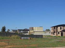 New houses at Bundalong | |||||||||||||||
 Bundalong | |||||||||||||||
| Coordinates | 36°02′S 146°10′E | ||||||||||||||
| Population | 428 (2016 census)[1] | ||||||||||||||
| Postcode(s) | 3730 | ||||||||||||||
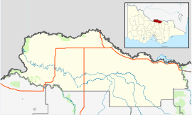
| Location |
| ||||||||||||||
| LGA(s) | Shire of Moira | ||||||||||||||
| State electorate(s) | Ovens Valley | ||||||||||||||
| Federal Division(s) | Nicholls | ||||||||||||||
| |||||||||||||||
History
The Bundalong Post office opened on 2 October 1876 and closed in 1940.[4]
References
- "2016 Census QuickStats Bundalong". Australian Bureau of Statistics. Retrieved 9 March 2019.
- "The Aboriginal and Other Meanings of many of our Region's Town Names". Retrieved 10 February 2010.
- Nassim Khadem and Melissa Marino (17 May 2005). "Control urged as drought hits meat prices". The Age. Melbourne. Retrieved 25 February 2010.
- Premier Postal History. "Post Office List". Retrieved 11 April 2008.
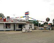
Bundalong General Store
| Wikimedia Commons has media related to Bundalong, Victoria. |
This article is issued from Wikipedia. The text is licensed under Creative Commons - Attribution - Sharealike. Additional terms may apply for the media files.