Bristol, Indiana
Bristol is a town in Washington Township, Elkhart County, Indiana, United States. The population was 1,602 at the 2010 census.
Town of Bristol, Indiana | |
|---|---|
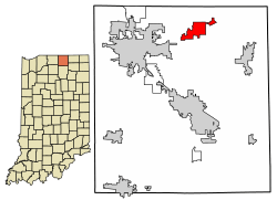 Location of Bristol in Elkhart County, Indiana. | |
| Coordinates: 41°43′16″N 85°49′06″W | |
| Country | United States |
| State | Indiana |
| County | Elkhart |
| Township | Washington |
| Area | |
| • Total | 4.15 sq mi (10.75 km2) |
| • Land | 4.02 sq mi (10.41 km2) |
| • Water | 0.13 sq mi (0.34 km2) |
| Elevation | 748 ft (228 m) |
| Population | |
| • Total | 1,602 |
| • Estimate (2018)[4] | 1,686 |
| • Density | 418.76/sq mi (161.67/km2) |
| Time zone | UTC-5 (EST) |
| • Summer (DST) | UTC-5 (EST) |
| ZIP code | 46507 |
| Area code | 574 |
| FIPS code[2][5] | 18-07750 |
| GNIS ID[2][5] | 431536 |
| Website | www |
History
Bristol was platted about 1835, making it one of the oldest towns in Elkhart County.[6] It was named after the city of Bristol, in England.[7][8]
The Bristol-Washington Township School, Solomon Fowler Mansion, and St. John of the Cross Episcopal Church, Rectory and Cemetery are listed on the National Register of Historic Places.[9]
Geography
Bristol is located at 41°43′16″N 85°49′6″W (41.721050, -85.818195).[10]
According to the 2010 census, Bristol has a total area of 3.82 square miles (9.89 km2), of which 3.69 square miles (9.56 km2) (or 96.6%) is land and 0.13 square miles (0.34 km2) (or 3.4%) is water.[11]
Demographics
| Historical population | |||
|---|---|---|---|
| Census | Pop. | %± | |
| 1870 | 681 | — | |
| 1880 | 661 | −2.9% | |
| 1890 | 535 | −19.1% | |
| 1900 | 546 | 2.1% | |
| 1910 | 535 | −2.0% | |
| 1920 | 568 | 6.2% | |
| 1930 | 699 | 23.1% | |
| 1940 | 694 | −0.7% | |
| 1950 | 738 | 6.3% | |
| 1960 | 991 | 34.3% | |
| 1970 | 1,100 | 11.0% | |
| 1980 | 1,203 | 9.4% | |
| 1990 | 1,133 | −5.8% | |
| 2000 | 1,382 | 22.0% | |
| 2010 | 1,602 | 15.9% | |
| Est. 2019 | 1,692 | [4] | 5.6% |
| U.S. Decennial Census[12] | |||
2010 census
As of the 2010 census,[3] there were 1,602 people, 608 households, and 429 families living in the town. The population density was 434.1 inhabitants per square mile (167.6/km2). There were 737 housing units at an average density of 199.7 per square mile (77.1/km2). The racial makeup of the town was 87.9% White, 2.1% African American, 0.7% Native American, 1.5% Asian, 4.7% from other races, and 3.1% from two or more races. Hispanic or Latino of any race were 10.2% of the population.
There were 608 households of which 34.4% had children under the age of 18 living with them, 50.8% were married couples living together, 11.8% had a female householder with no husband present, 7.9% had a male householder with no wife present, and 29.4% were non-families. 22.2% of all households were made up of individuals and 8.2% had someone living alone who was 65 years of age or older. The average household size was 2.62 and the average family size was 3.04.
The median age in the town was 36.4 years. 27% of residents were under the age of 18; 7.5% were between the ages of 18 and 24; 25.3% were from 25 to 44; 26% were from 45 to 64; and 14.4% were 65 years of age or older. The gender makeup of the town was 49.6% male and 50.4% female.
2000 census
As of the 2000 census,[13] there were 1,382 people, 539 households, and 368 families living in the town. The population density was 579.8 people per square mile (224.2/km²). There were 559 housing units at an average density of 234.5 per square mile (90.7/km²). The racial makeup of the town was 90.09% White, 1.16% African American, 0.36% Native American, 1.23% Asian, 0.07% Pacific Islander, 4.27% from other races, and 2.82% from two or more races. Hispanic or Latino of any race were 7.67% of the population.
There were 539 households out of which 34.9% had children under the age of 18 living with them, 51.9% were married couples living together, 9.8% had a female householder with no husband present, and 31.7% were non-families. 23.9% of all households were made up of individuals and 5.0% had someone living alone who was 65 years of age or older. The average household size was 2.56 and the average family size was 3.02.
In the town, the population was spread out with 27.6% under the age of 18, 11.2% from 18 to 24, 31.0% from 25 to 44, 19.5% from 45 to 64, and 10.8% who were 65 years of age or older. The median age was 31 years. For every 100 females, there were 100.0 males. For every 100 females age 18 and over, there were 101.0 males.
The median income for a household in the town was $46,136, and the median income for a family was $54,125. Males had a median income of $35,568 versus $24,938 for females. The per capita income for the town was $20,373. About 5.1% of families and 5.9% of the population were below the poverty line, including 6.9% of those under age 18 and 2.7% of those age 65 or over.
Education
Bristol is served by Elkhart Community Schools.[14]
Bristol-Washington Township Public Library
The town has a free independent lending library, the Bristol-Washington Township Public Library.[15] The current 10,000 square foot building was constructed in 1984.[16] In 2016, it served a population of 6,945 patrons and had 39,000 annual visits. In 2016 the library had a holding of 44,576 items which circulated 77,799 times.[17] The library provides and receives interlibrary loans through the Indiana Share program.[18]
Notable Buildings
- The Bristol Opera House, once known as the Moiser Opera House, was built in 1896.[19] The Elkhart Civic Theatre currently presents plays there.[20]
- The Elkhart County Historical Museum, founded in 1968 as a partnership between Elkhart's Historical Society and County Parks Department, occupies the former Bristol-Washington Township School (AKA Bristol High School). It is home to 30,000 artifacts and receives around 10,000 visits each year.[21]
References
- "2017 U.S. Gazetteer Files". United States Census Bureau. Retrieved Dec 30, 2018.
- "Feature ID 431536". Geographic Names Information System. United States Geological Survey. Retrieved June 30, 2014.
- "U.S. Census website". United States Census Bureau. Retrieved 2012-12-11.
- "Population and Housing Unit Estimates". Retrieved January 12, 2020.
- "FIPS55 Data: Indiana". FIPS55 Data. United States Geological Survey. February 23, 2006. Archived from the original on June 18, 2006. Retrieved June 30, 2014.
- Deahl, Anthony (1905). A Twentieth Century History and Biographical Record of Elkhart County, Indiana. Lewis Publishing Company. pp. 112.
- Baker, Ronald L. (October 1995). From Needmore to Prosperity: Hoosier Place Names in Folklore and History. Indiana University Press. p. 76. ISBN 978-0-253-32866-3.
...named for Bristol, England...
- Dept. of English and Journalism (1970–72). Indiana names, v.1-3. Indiana State University. p. 15.
- "National Register Information System". National Register of Historic Places. National Park Service. July 9, 2010.
- "US Gazetteer files: 2010, 2000, and 1990". United States Census Bureau. 2011-02-12. Retrieved 2011-04-23.
- "G001 - Geographic Identifiers - 2010 Census Summary File 1". United States Census Bureau. Archived from the original on 2020-02-13. Retrieved 2015-07-13.
- "Census of Population and Housing". Census.gov. Retrieved June 4, 2015.
- "U.S. Census website". United States Census Bureau. Retrieved 2008-01-31.
- "SCHOOL DISTRICT REFERENCE MAP (2010 CENSUS): Elkhart County, IN." U.S. Census Bureau. Retrieved on December 6, 2016.
- "Indiana public library directory" (PDF). Indiana State Library. Retrieved 7 March 2018.
- "Library Facilities and Construction Status". Indiana State Library. Retrieved 29 April 2018.
- "Indiana Public library 2016 Holdings and Ciruclations" (PDF). Indiana State Library. Retrieved 29 April 2018.
- "Indiana public library 2016 statistics". Indiana State Library. Retrieved 29 April 2018.
- https://digital.library.in.gov/Record/ISL_p181901coll1-663
- https://elkhartcivictheatre.org/our-history/
- "Elkhart County Museum About". Elkhart County Historical Museum.
External links
Municipalities and communities of Elkhart County, Indiana, United States | ||
|---|---|---|
| Cities | Map of Indiana highlighting Elkhart County | |
| Towns | ||
| Townships | ||
| CDPs | ||
| Unincorporated communities | ||
| Footnotes | ‡This populated place also has portions in an adjacent county or counties | |