Brinson, Georgia
Brinson is a town in Decatur County, Georgia, United States. As of the 2010 census, the city had a population of 215.[5]
Brinson, Georgia | |
|---|---|
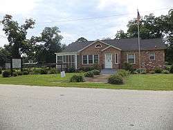 Brinson Town Hall | |
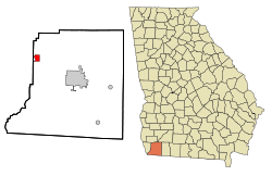 Location in Decatur County and the state of Georgia | |
| Coordinates: 30°58′45″N 84°44′10″W | |
| Country | United States |
| State | Georgia |
| County | Decatur |
| Area | |
| • Total | 2.04 sq mi (5.29 km2) |
| • Land | 2.04 sq mi (5.29 km2) |
| • Water | 0.00 sq mi (0.00 km2) |
| Elevation | 121 ft (37 m) |
| Population (2010) | |
| • Total | 215 |
| • Estimate (2018)[2] | 204 |
| • Density | 99.95/sq mi (38.60/km2) |
| Time zone | UTC-5 (Eastern (EST)) |
| • Summer (DST) | UTC-4 (EDT) |
| ZIP codes | 31725, 39825 |
| Area code(s) | 229 |
| FIPS code | 13-10608[3] |
| GNIS feature ID | 0354857[4] |
| Website | georgiainfo |
History
Variant names were "Mount Zion and "Spring Creek.[6] Simeon Brinson, an early postmaster and first mayor, gave the town its present name.[6] The Georgia General Assembly incorporated the place as the "Town of Brinson" in 1907.[7]
Agriculture predominates in the area. According to one compilation, three of the top ten recipients of U.S. farm subsidies are in Brinson.[8]
Geography
Brinson is located in northwestern Decatur County at 30°58′45″N 84°44′10″W (30.979029, -84.736059).[9] U.S. Route 84 passes through the southwest side of the town, leading southeast 10 miles (16 km) to Bainbridge, the Decatur County seat, and northwest 44 miles to Dothan, Alabama.
According to the United States Census Bureau, Brinson has a total area of 2.0 square miles (5.3 km2), all land.[10]
Demographics
| Historical population | |||
|---|---|---|---|
| Census | Pop. | %± | |
| 1910 | 707 | — | |
| 1920 | 470 | −33.5% | |
| 1930 | 368 | −21.7% | |
| 1940 | 305 | −17.1% | |
| 1950 | 248 | −18.7% | |
| 1960 | 246 | −0.8% | |
| 1970 | 231 | −6.1% | |
| 1980 | 274 | 18.6% | |
| 1990 | 238 | −13.1% | |
| 2000 | 225 | −5.5% | |
| 2010 | 215 | −4.4% | |
| Est. 2018 | 204 | [2] | −5.1% |
| U.S. Decennial Census[11] | |||
At the 2000 census,[3] there were 225 people, 90 households and 63 families residing in the town. The population density was 120.3 per square mile (46.5/km²). There were 106 housing units at an average density of 56.7 per square mile (21.9/km²). The racial makeup of the town was 72.89% White, 23.56% African American, 0.89% Native American, 1.33% from other races, and 1.33% from two or more races. Hispanic or Latino of any race were 3.56% of the population.
There were 90 households of which 33.3% had children under the age of 18 living with them, 54.4% were married couples living together, 11.1% had a female householder with no husband present, and 28.9% were non-families. 26.7% of all households were made up of individuals and 15.6% had someone living alone who was 65 years of age or older. The average household size was 2.50 and the average family size was 3.08.
Age distribution was 24.9% under the age of 18, 5.8% from 18 to 24, 28.9% from 25 to 44, 24.4% from 45 to 64, and 16.0% who were 65 years of age or older. The median age was 40 years. For every 100 females, there were 97.4 males. For every 100 females age 18 and over, there were 89.9 males.
The median household income was $27,321, and the median family income was $31,250. Males had a median income of $21,458 versus $13,750 for females. The per capita income for the town was $12,613. About 11.5% of families and 13.9% of the population were below the poverty line, including 11.1% of those under the age of eighteen and 10.0% of those sixty five or over.
References
- "2018 U.S. Gazetteer Files". United States Census Bureau. Retrieved Feb 12, 2020.
- "Population and Housing Unit Estimates". Retrieved June 4, 2019.
- "U.S. Census website". United States Census Bureau. Retrieved 2008-01-31.
- "US Board on Geographic Names". United States Geological Survey. 2007-10-25. Retrieved 2008-01-31.
- "Table". factfinder2.census.gov. Archived from the original (PDF) on 2020-02-12. Retrieved 2019-07-09.
- Krakow, Kenneth K. (1975). Georgia Place-Names: Their History and Origins (PDF). Macon, GA: Winship Press. p. 25. ISBN 0-915430-00-2.
- Acts and Resolutions of the General Assembly of the State of Georgia. Clark & Hines, State Printers. 1907. p. 484.
- Adam Andrzejewski (2018-08-14). "Mapping The U.S. Farm Subsidy $1M Club". Forbes.com. Retrieved 2019-07-09.
- "US Gazetteer files: 2010, 2000, and 1990". United States Census Bureau. 2011-02-12. Retrieved 2011-04-23.
- "Geographic Identifiers: 2010 Demographic Profile Data (G001): Brinson town, Georgia". U.S. Census Bureau, American Factfinder. Retrieved October 20, 2015.
- "Census of Population and Housing". Census.gov. Retrieved June 4, 2015.
External links
- Brinson historical marker
Municipalities and communities of Decatur County, Georgia, United States | ||
|---|---|---|
| Cities | 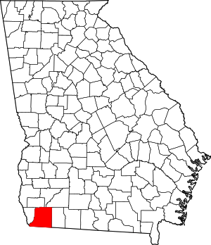 Map of Georgia highlighting Decatur County | |
| Town | ||
| Unincorporated communities | ||
| Ghost towns | ||
| Footnotes | ‡This populated place also has portions in an adjacent county or counties | |