Breuil-le-Vert
Breuil-le-Vert is a commune in the Oise department in northern France
Breuil-le-Vert | |
|---|---|
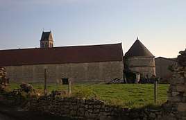 The church in Breuil-le-Vert | |
 Coat of arms | |
Location of Breuil-le-Vert 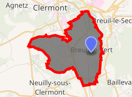
| |
 Breuil-le-Vert  Breuil-le-Vert | |
| Coordinates: 49°21′42″N 2°26′15″E | |
| Country | France |
| Region | Hauts-de-France |
| Department | Oise |
| Arrondissement | Clermont |
| Canton | Clermont |
| Intercommunality | Pays du Clermontois |
| Government | |
| • Mayor (2008–2014) | Jean-Philippe Vichard |
| Area 1 | 7.37 km2 (2.85 sq mi) |
| Population (2017-01-01)[1] | 3,087 |
| • Density | 420/km2 (1,100/sq mi) |
| Time zone | UTC+01:00 (CET) |
| • Summer (DST) | UTC+02:00 (CEST) |
| INSEE/Postal code | 60107 /60600 |
| Elevation | 45–150 m (148–492 ft) (avg. 51 m or 167 ft) |
| 1 French Land Register data, which excludes lakes, ponds, glaciers > 1 km2 (0.386 sq mi or 247 acres) and river estuaries. | |
Population
| Historical population | ||
|---|---|---|
| Year | Pop. | ±% |
| 1793 | 580 | — |
| 1800 | 705 | +21.6% |
| 1806 | 753 | +6.8% |
| 1821 | 736 | −2.3% |
| 1831 | 813 | +10.5% |
| 1836 | 825 | +1.5% |
| 1841 | 797 | −3.4% |
| 1846 | 817 | +2.5% |
| 1851 | 796 | −2.6% |
| 1856 | 801 | +0.6% |
| 1861 | 817 | +2.0% |
| 1866 | 837 | +2.4% |
| 1872 | 851 | +1.7% |
| 1876 | 840 | −1.3% |
| 1881 | 803 | −4.4% |
| 1886 | 841 | +4.7% |
| 1891 | 786 | −6.5% |
| 1896 | 776 | −1.3% |
| 1901 | 752 | −3.1% |
| 1906 | 761 | +1.2% |
| 1911 | 749 | −1.6% |
| 1921 | 777 | +3.7% |
| 1926 | 793 | +2.1% |
| 1931 | 802 | +1.1% |
| 1936 | 827 | +3.1% |
| 1946 | 1,010 | +22.1% |
| 1954 | 993 | −1.7% |
| 1962 | 960 | −3.3% |
| 1968 | 1,106 | +15.2% |
| 1975 | 1,486 | +34.4% |
| 1982 | 2,127 | +43.1% |
| 1990 | 2,785 | +30.9% |
| 1999 | 2,815 | +1.1% |
| 2006 | 2,834 | +0.7% |
| 2009 | 2,842 | +0.3% |
| 2012 | 2,900 | +2.0% |
See also
References
- "Populations légales 2017". INSEE. Retrieved 6 January 2020.
| Wikimedia Commons has media related to Breuil-le-Vert. |
| Authority control |
|
|---|
This article is issued from Wikipedia. The text is licensed under Creative Commons - Attribution - Sharealike. Additional terms may apply for the media files.