Brauro Cove
Brauro Cove (Bulgarian: Ивайлов залив, ‘Ivaylov Zaliv’ \i-'vay-lov 'za-liv\) is the 1.93 km wide cove indenting for 620 m the northwest coast of Snow Island in the South Shetland Islands, Antarctica. It is entered southwest of Mezdra Point and northeast of Irnik Point.[1]
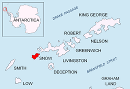
Location of Snow Island in the South Shetland Islands
Location
Brauro Cove is centred at 62°43′15″S 61°21′20″W. British mapping in 1968, Bulgarian in 2009 and 2017.
Maps
- Livingston Island to King George Island. Scale 1:200000. Admiralty Chart 1776. UK Hydrographic Office, 1968
- L.L. Ivanov. Antarctica: Livingston Island and Greenwich, Robert, Snow and Smith Islands. Scale 1:120000 topographic map. Troyan: Manfred Wörner Foundation, 2009. ISBN 978-954-92032-6-4
- L.L. Ivanov. Antarctica: Livingston Island and Smith Island. Scale 1:100000 topographic map. Manfred Wörner Foundation, 2017. ISBN 978-619-90008-3-0
- Antarctic Digital Database (ADD). Scale 1:250000 topographic map of Antarctica. Scientific Committee on Antarctic Research (SCAR). Since 1993, regularly upgraded and updated
Notes
- Brauro Cove. SCAR Composite Gazetteer of Antarctica
References
- Brauro Cove. SCAR Composite Gazetteer of Antarctica
- Bulgarian Antarctic Gazetteer. Antarctic Place-names Commission. (details in Bulgarian, basic data in English)
External links
- Brauro Cove. Adjusted Copernix satellite image
This article includes information from the Antarctic Place-names Commission of Bulgaria which is used with permission.
This article is issued from Wikipedia. The text is licensed under Creative Commons - Attribution - Sharealike. Additional terms may apply for the media files.