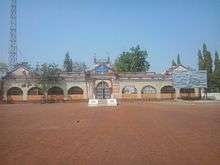
Bramhapuri
Bramhapuri is a Large Village and municipal council in Chandrapur district in the state of Maharashtra, India.
Bramhapuri | |
|---|---|
town | |
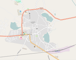 Overview of Bramhapuri Town | |
 Bramhapuri Location in Maharashtra, India | |
| Coordinates: 20.6068°N 79.8644°E | |
| Country | |
| State | Maharashtra |
| District | Chandrapur |
| Area | |
| • Total | 15 km2 (6 sq mi) |
| Elevation | 229.5 m (753.0 ft) |
| Population (2001) | |
| • Total | 31,207 |
| • Density | 2,100/km2 (5,400/sq mi) |
| Languages | |
| • Official | Marathi |
| Time zone | UTC+5:30 (IST) |
| PIN | 441206 |
| Telephone code | 07177 |
| Vehicle registration | MH34 |
| Nearest city | Nagpur |
Geography
Bramhapuri is one of the six divisions located in the northeastern part of Chandrapur district, Maharashtra at 20.36°N 79.51°E and has an average elevation of 229.5 metres (753 feet). Bramhapuri is a vidhan sabha constituency. It is old taluka headquarter of Chandrapur district. The city contains subdivision offices, MSEB division office, forest division office, FDCM division office, Gosekhurd division office, ST depot, railway station, post office.
Demographics
According to 2011 Indian census,[1] Bramhapuri had a population of 36,025. Males constitute 51% of the population and females 49%. Bramhapuri has an average literacy rate of 76%, higher than the national average of 59.5%; with male literacy of 82% and female literacy of 69%. 12% of the population is under six years of age.
History
Bramhapuri was also a city in the Satavahana dynasty, with many burnt-brick houses, numerous glass beads and coins.[2] Many bronze objects were excavated from there, many of which are Indian but few were also of Roman and Italian origin, that can be attributed to the Satavahana period.[3]
In 1854, when Chandrapur was formed as an independent district, it included Bramhapuri as a tehsil in 1874. Afterwards a new tehsil with headquarters at Gadchiroli was created in 1905 by transfer of zamindari estates from Bramhapuri and Chandrapur tehsil.
Climate
The climate here is generally hot and dry whereas in the rainy season it is humid and the rainfall is quite heavy. The temperature in summer goes above 45 °C and in winter drops below 10 °C. In the last few years this town has been listed among the top five hottest cities of India.[4]
| Climate data for Bramhapuri (1981–2010, extremes 1956–2011) | |||||||||||||
|---|---|---|---|---|---|---|---|---|---|---|---|---|---|
| Month | Jan | Feb | Mar | Apr | May | Jun | Jul | Aug | Sep | Oct | Nov | Dec | Year |
| Record high °C (°F) | 37.4 (99.3) |
39.1 (102.4) |
42.5 (108.5) |
45.5 (113.9) |
47.7 (117.9) |
47.7 (117.9) |
40.2 (104.4) |
37.0 (98.6) |
37.6 (99.7) |
37.1 (98.8) |
39.1 (102.4) |
37.2 (99.0) |
47.7 (117.9) |
| Average high °C (°F) | 29.1 (84.4) |
32.1 (89.8) |
36.5 (97.7) |
40.6 (105.1) |
42.4 (108.3) |
37.4 (99.3) |
31.2 (88.2) |
30.4 (86.7) |
31.9 (89.4) |
32.5 (90.5) |
30.9 (87.6) |
29.2 (84.6) |
33.7 (92.7) |
| Average low °C (°F) | 13.1 (55.6) |
15.7 (60.3) |
19.8 (67.6) |
24.5 (76.1) |
27.3 (81.1) |
26.0 (78.8) |
23.6 (74.5) |
23.3 (73.9) |
23.3 (73.9) |
20.8 (69.4) |
16.4 (61.5) |
12.4 (54.3) |
20.5 (68.9) |
| Record low °C (°F) | 0.8 (33.4) |
5.1 (41.2) |
10.3 (50.5) |
12.8 (55.0) |
13.4 (56.1) |
8.7 (47.7) |
13.9 (57.0) |
14.0 (57.2) |
14.9 (58.8) |
7.6 (45.7) |
6.2 (43.2) |
2.6 (36.7) |
0.8 (33.4) |
| Average rainfall mm (inches) | 14.1 (0.56) |
14.4 (0.57) |
16.7 (0.66) |
14.2 (0.56) |
21.1 (0.83) |
166.1 (6.54) |
404.0 (15.91) |
386.6 (15.22) |
175.5 (6.91) |
61.2 (2.41) |
13.1 (0.52) |
9.9 (0.39) |
1,296.9 (51.06) |
| Average rainy days | 1.1 | 1.3 | 1.5 | 1.5 | 1.6 | 7.9 | 15.8 | 15.0 | 9.0 | 3.0 | 0.5 | 0.6 | 58.7 |
| Average relative humidity (%) (at 17:30 IST) | 43 | 37 | 31 | 27 | 27 | 52 | 73 | 77 | 71 | 59 | 48 | 44 | 49 |
| Source: India Meteorological Department[5][6] | |||||||||||||
References
- "Census of India 2001: Data from the 2001 Census, including cities, villages and towns (Provisional)". Census Commission of India. Archived from the original on 16 June 2004. Retrieved 1 November 2008.
- Allchin, F. R.; Erdosy, George (7 September 1995). The Archaeology of Early Historic South Asia: The Emergence of Cities and States. Cambridge University Press. ISBN 9780521376952.
- Dhavalikar, M.K. (2004). Satavahana Art. Sharada Publishing House. p. 91. ISBN 81-88934-04-6.
- "Bhira in Maharashtra hottest in India on Saturday". The Times of India. 26 March 2017.
- "Station: Brahmapuri Climatological Table 1981–2010" (PDF). Climatological Normals 1981–2010. India Meteorological Department. January 2015. pp. 157–158. Archived from the original (PDF) on 5 February 2020. Retrieved 3 April 2020.
- "Extremes of Temperature & Rainfall for Indian Stations (Up to 2012)" (PDF). India Meteorological Department. December 2016. p. M140. Archived from the original (PDF) on 5 February 2020. Retrieved 3 April 2020.
Chandrapur district topics | ||
|---|---|---|
| History | 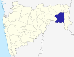 | |
| Geography |
| |
| Cities and towns | ||
| Lok Sabha constituencies |
| |
| Vidhan Sabha constituencies | ||