Brackley, Templeport
Brackley (from Irish: Breac Loch meaning 'Speckled Lake' or less likely Breaclaí meaning "Speckled Land") is a townland in the civil parish of Templeport, County Cavan, Ireland. It lies in the Roman Catholic parish of Templeport and barony of Tullyhaw.
Geography
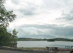
Brackley is bounded on the north by Mullaghlea townland, on the west by Prospect, Corlough parish and Derrymony townlands, on the south by Killyneary, Carrick East and Gortnavreeghan townlands and on the east by Mullanacre Upper townland in Tomregan parish. Its chief geographical features are Slieve Rushen mountain on whose western slope it lies, Brackley Lough, mountain streams, mountain bogs, Brackley Wood, forestry plantations, stone quarries and dug wells. It forms part of the Slieve Rushen Bog Natural Heritage Area An island in Brackley Lough is called the Baron's Island after a Baron de Trent who lived in Brackley House c.1850 and who built a studio on the island. Brackley is traversed by the regional N87 road (Ireland) and rural lanes. The townland covers 619 statute acres.[1]
History
The 1609 Baronial Map depicts the townland as Brockl.[2]
The 1652 Commonwealth Survey lists the townland as Bracklagh.
The 1665 Down Survey map depicts the townland as Bracklogh.[3]
William Petty's 1685 map depicts it as Bracklough.[4]
On 12 November 1590 Queen Elizabeth I of England granted a pardon (No. 5489) to Ferrall M'Gawran of Breachlaghe, gentleman for fighting against the Queen's forces.[5] He was probably the same man who had already been pardoned on 19 January 1586 (No. 4813, Ferriell M'Manus M'Thomas Magawran of Killsollaghe), so he was still fighting against the English three years later. The said Farrell McGovern was the grandson of Tomás mac Maghnus Mág Samhradháin who was chief of the McGovern Clan from 1512 to 1532.
In the Plantation of Ulster by grant dated 26 June 1615, King James VI and I granted, inter alia, two polls in Bracklee to Sir George Graeme and Sir Richard Graeme to form part of the Manor of Greame.[6] An Inquisition held at Cavan Town on 31 October 1627 found that George Greames was seized of one poll in Brackley and he died 9 October 1624. By his will dated 1 May 1615 he left his lands to his son and heir William Greames then 30 years old (born 1594) and unmarried.[7]
The Grahams fought on the Irish side during the Irish Rebellion of 1641 and, as a result after the end of the war, the Cromwellian Act for the Settlement of Ireland 1652 confiscated their lands in Brackley and distributed them as follows-
The 1652 Commonwealth Survey lists the proprietor as being Mr Thomas Worsopp and the tenant being William Lawther, both of whom appear as proprietor and tenant for several other Templeport townlands in the same survey.
In the Hearth Money Rolls compiled on 29 September 1663[8] there were three Hearth Tax payers in Bracklagh- Hugh McBrien, Phelemy McBrien and Farrall McBrien.
A deed dated 9 December 1710 From Ralph Darling and Adam Darling (the sons of Richard Darling, one of the founders of Swanlinbar town) assigned, inter alia, one quarter of Bracklough poll and other lands bought from Sir Thomas Worsop, to Peter Ward, a merchant of Dublin.
A lease dated 23 January 1717 from Morley Saunders to John Enery of Bawnboy includes that part of Bracklagh called Bonbegg.[9]
In the Templeport Poll Book of 1761 there were only three people registered to vote in Brockly in the 1761 Irish general election[10] - Francis Dowler, John Dowler and John McGee. They were entitled to two votes each. The Dowlers both voted for Lord Newtownbutler (later Brinsley Butler, 2nd Earl of Lanesborough) who was elected Member of Parliament for Cavan County and for George Montgomery (MP) of Ballyconnell, who lost the election. McGee voted for Lord Newtownbutler (later Brinsley Butler, 2nd Earl of Lanesborough) who was elected Member of Parliament for Cavan County and for Barry Maxwell, 1st Earl of Farnham, who lost the election. Absence from the poll book either meant a resident did not vote or more likely was not a freeholder entitled to vote, which would mean most of the inhabitants of Brackley.
A lease dated 10 December 1774 from William Crookshank to John Enery of Bawnboy includes the lands of Brackley and Boonbegg.[11] A further deed by John Enery dated 13 December 1774 includes the three poles of Brackley otherwise Bracklea.[12]
The 1790 Cavan Carvaghs list spells the townland name as Bracklagh.[13]
A lease dated 17 September 1816 John Enery of Bawnboy includes Brackley otherwise called the two Brackleys.[14]
In the 1825 Registry of Freeholders for County Cavan there was one freeholder registered in Brackley- Michael Cassidy. He was a Forty-shilling freeholders holding a lease for lives from his landlord, Francis Finley.
The Tithe Applotment Books for 1827 list nineteen tithepayers in the townland.[15]
In 1833 two people in Brackley were registered as a keeper of weapons- Charles Carson and Launcelott Fiffe.[16]
The Brackley Valuation Office Field books are available for 1839-1840.[17][18][19][20][21][22]
Griffith's Valuation of 1857 lists thirty nine landholders in the townland.[23]
On 12 June 1921, Dean John Finlay, a 78 year old Protestant clergyman, was shot dead in an IRA raid on his home at Brackley House.
Brackley School
Brackley School was actually located in the townland of Mullaghlea, not Brackley.
Census
| Year | Population | Males | Females | Total Houses | Uninhabited |
|---|---|---|---|---|---|
| 1841 | 170 | 90 | 80 | 31 | 2 |
| 1851 | 132 | 72 | 60 | 24 | 0 |
| 1861 | 122 | 66 | 56 | 20 | 0 |
| 1871 | 83 | 48 | 35 | 18 | 0 |
| 1881 | 84 | 44 | 40 | 20 | 4 |
| 1891 | 70 | 38 | 32 | 14 | 1 |
In the 1901 census of Ireland, there are fourteen families listed in the townland, [24] and in the 1911 census of Ireland, there are thirteen families listed in the townland.[25]
Antiquities
The chief structures of historical interest in the townland are:
References
- "IreAtlas". Retrieved 29 February 2012.
- National Archives Dublin
- Trinity College Dublin: The Down Survey of Ireland.
- Chancery, Ireland (11 April 1800). "Calendar of the Patent Rolls of the Chancery of Ireland". A. Thom – via Google Books.
- "Inquisitionum in Officio Rotulorum Cancellariae Hiberniae Asservatarum Repertorium". command of his majesty King George IV. In pursuance of an address of the house of Commons of Great Britain (an Ireland). 11 April 1829 – via Google Books.
- The Hearth Money Rolls for the Baronies of Tullyhunco and Tullyhaw, County Cavan, edited by Rev. Francis J. McKiernan, in Breifne Journal. Vol. I, No. 3 (1960), pp. 247-263
- and and
- Census of Ireland 1911
- Site number 264 in "Archaeological Inventory of County Cavan", Patrick O’Donovan, 1995, where it is described as- Marked 'Fort' on OS 1836 and 1876 eds. Site is said to have comprised a raised circular area enclosed by two massive earthen banks with an intervening fosse (local information). Situated in mountainous land, adjacent to a stream. The site lies within a dense modern plantation of coniferous trees. Not located..
External links
Places in County Cavan | ||
|---|---|---|
| Towns |  | |
| Villages |
| |
| Townlands | ||
| ||