Boule-d'Amont
Boule-d'Amont (Catalan: Bula d'Amunt) is a commune in the Pyrénées-Orientales department in southern France.
Boule-d'Amont Bula d'Amunt | |
|---|---|
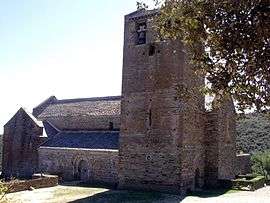 The Serrabone Priory and church | |
Location of Boule-d'Amont 
| |
 Boule-d'Amont  Boule-d'Amont | |
| Coordinates: 42°34′50″N 2°36′51″E | |
| Country | France |
| Region | Occitanie |
| Department | Pyrénées-Orientales |
| Arrondissement | Prades |
| Canton | Le Canigou |
| Intercommunality | Roussillon Conflent |
| Government | |
| • Mayor (2014–2020) | Yann Oheix |
| Area 1 | 23.22 km2 (8.97 sq mi) |
| Population (2017-01-01)[1] | 55 |
| • Density | 2.4/km2 (6.1/sq mi) |
| Time zone | UTC+01:00 (CET) |
| • Summer (DST) | UTC+02:00 (CEST) |
| INSEE/Postal code | 66022 /66130 |
| Elevation | 234–1,348 m (768–4,423 ft) (avg. 483 m or 1,585 ft) |
| 1 French Land Register data, which excludes lakes, ponds, glaciers > 1 km2 (0.386 sq mi or 247 acres) and river estuaries. | |
Geography
Localisation
Boule-d'Amont is located in the canton of Le Canigou and in the arrondissement of Prades.
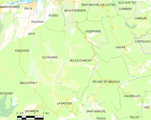
Map of Boule-d'Amont and its surrounding communes
Neighbouring communes
Places adjacent to Boule-d'Amont | |
|---|---|

Government and politics
- Mayors
| Mayor | Term start | Term end |
|---|---|---|
| Gérard Llense | 1983 | 2014 |
| Yann Oheix | 2014 |
Population
| Historical population | ||
|---|---|---|
| Year | Pop. | ±% |
| 1793 | 325 | — |
| 1800 | 286 | −12.0% |
| 1806 | 329 | +15.0% |
| 1821 | 339 | +3.0% |
| 1831 | 522 | +54.0% |
| 1836 | 536 | +2.7% |
| 1841 | 557 | +3.9% |
| 1846 | 561 | +0.7% |
| 1851 | 526 | −6.2% |
| 1856 | 498 | −5.3% |
| 1861 | 494 | −0.8% |
| 1866 | 481 | −2.6% |
| 1872 | 427 | −11.2% |
| 1876 | 393 | −8.0% |
| 1881 | 374 | −4.8% |
| 1886 | 368 | −1.6% |
| 1891 | 398 | +8.2% |
| 1896 | 384 | −3.5% |
| 1901 | 372 | −3.1% |
| 1906 | 362 | −2.7% |
| 1911 | 380 | +5.0% |
| 1921 | 235 | −38.2% |
| 1926 | 185 | −21.3% |
| 1931 | 168 | −9.2% |
| 1936 | 143 | −14.9% |
| 1946 | 149 | +4.2% |
| 1954 | 110 | −26.2% |
| 1962 | 91 | −17.3% |
| 1968 | 69 | −24.2% |
| 1975 | 47 | −31.9% |
| 1982 | 70 | +48.9% |
| 1990 | 71 | +1.4% |
| 1999 | 73 | +2.8% |
| 2007 | 55 | −24.7% |
| 2009 | 57 | +3.6% |
References
- "Populations légales 2017". INSEE. Retrieved 6 January 2020.
| Wikimedia Commons has media related to Boule-d'Amont. |
| Authority control |
|
|---|
This article is issued from Wikipedia. The text is licensed under Creative Commons - Attribution - Sharealike. Additional terms may apply for the media files.