Bostanliq District
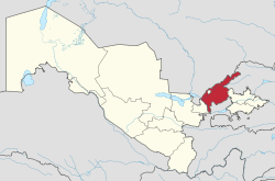
Bostanliq is a raion (district) of Tashkent Region in Uzbekistan. The capital lies at Gazalkent.[1]
Bostanliq | |
|---|---|
| Boʻstonliq tumani | |
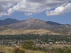 Panorama of Chorvoq and Ugam Range | |
| Country | Uzbekistan |
| Region | Tashkent Region |
| Capital | Gazalkent |
| Established | 1955 |
| Area | |
| • Total | 570 km2 (220 sq mi) |
| Population | |
| • Total | 159 700 |
| Time zone | UTC+5 (UZT) |
Geography
Climate
The climate of the region is temperate continental, with hot summers and fairly cold winters. The average annual temperature is +15.0 ° C; The average January temperature is -9.0 ° C, the average July temperature is +21.0 ° C. The absolute minimum temperature was –26 ° C, the absolute temperature maximum +46 ° C. On average, 500–600 mm of rainfall per year falls on the territory of the district (most of the precipitation falls in spring and autumn). The growing season lasts 210–215 days.[2]
Topography
The relief of the Bostanliq district is relatively monotonous and is represented mainly by hills, mountains and high mountains. Lowlands are widespread in the western and part of the southern part of the region, adyrs are widespread except in the northern part, where there are only high mountains. Almost all the territory where the high mountain systems, the eastern Tien Shan, the Karzhantau ridge, the Pskem Mountains, the Ugam ridge and the Chatkal ridge are located, is occupied by mountains. The heights in the district accordingly increase in direction from west to east and from south to north. The southern and western parts of the region are on average 1000 meters above sea level. The rest of the region where the highlands prevail, is located at an altitude of 1,200 to 4,000 meters above sea level. The highest point of the area is the peak of the Adelung Pskem ridge with an altitude of 4301 meters. In the second place in height, the mountain is another peak of the Pskem ridge - Beshtor with a height of 4299 meters. In addition to the peaks and peaks listed above, there are many high mountains and peaks in the district, which are between 1,000 and 4,000 meters above sea level. The largest and most significant peaks and peaks of the region: Aktash, Big Chimgan, Kyzylnur, Mingbulak, Pulatkhan and others. Car passes pass through many relatively high mountains. The hills are formed mainly by sandstones and loess. The foot of many mountains are mainly composed of slate and granite. The territory of the region is included in a seismic zone and annually from 5 to 8 or more earthquakes of various types occur in the region.[2]
Hydrography
Watercourses (sais), some of which turn into rivers, flow down almost from all mountain ranges. The main part of the sai and watercourses in the district are tributaries of the Chirchiq River. The largest of them are the Beldersay, the Pskem, the Ugam, the Koksu, and the Chimgansai. Another river flows through the district - the Chatkal, which is sometimes considered to be the left component of the Chirchiq River. The waters of almost all rivers flow into reservoirs, including the Charvak reservoir.[1] The waters of many rivers are used for irrigated agriculture, practiced on gentle slopes at the foot of the mountains. Groundwater is located in the district. Basically they are at a depth of 2-3 m to 6 to 20 meters.
The largest hydroelectric power station of Uzbekistan - Charvak hydroelectric power station is located on the territory of the Bostanlyk district. Annual electricity generation in this hydroelectric station is 2000 million kWh. The Charvak hydroelectric station, like other hydroelectric stations in the region, is part of one of the largest hydroelectric power stations in Central Asia - Chirchiq-Bozsuysky. Charvak reservoir is also located in the district.[2]
References
- "Чарвакское водохранилище" (in Russian). Central Asia Travel. Archived from the original on 5 March 2016. Retrieved 31 January 2016.
- Ўзбекистон табиий географияси. Издательство КГПИ имени Мукими. 2006.
Capital: Tashkent | ||
| Districts and seats |
|  |
| Other towns | ||