Blomberg, North Rhine-Westphalia
Blomberg is a town in the Lippe district of North Rhine-Westphalia, Germany, with c. 15,200 inhabitants (2018).
Blomberg | |
|---|---|
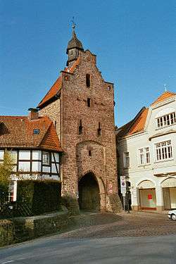 Niederntor, 15th-century tower in Blomberg. | |
 Coat of arms | |
Location of Blomberg within Lippe district   | |
 Blomberg 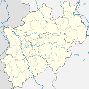 Blomberg | |
| Coordinates: 51°55′59″N 09°04′59″E | |
| Country | Germany |
| State | North Rhine-Westphalia |
| Admin. region | Detmold |
| District | Lippe |
| Subdivisions | 19 |
| Government | |
| • Mayor | Klaus Geise (SPD) |
| Area | |
| • Total | 99.1 km2 (38.3 sq mi) |
| Elevation | 185 m (607 ft) |
| Population (2018-12-31)[1] | |
| • Total | 15,154 |
| • Density | 150/km2 (400/sq mi) |
| Time zone | CET/CEST (UTC+1/+2) |
| Postal codes | 32825 |
| Dialling codes | 05235, 05236 |
| Vehicle registration | LIP |
| Website | www.blomberg-lippe.de |
Geography
Blomberg is 45 km south east of Bielefeld, 20 km east of Detmold and 17 km south west towards Bad Pyrmont. The district is located in the southern foothills of the Lippe mountain range and in the area of Blomberger and Schwalenberger Heights.
The core city is located in the center of the so-called Blomberger basin, which lies about 150 m above sea level and clearly separates itself from the surrounding area. The hem of the basin to the north and east are the approximately 400 m high wooded ridges of Barntruper and Blomberger Stadtwald with the Dicker, Becker and Winterberg. To the west are the Hörntruper Berg, the Meierberg, the Mossenberg (228 m) and the Püllenberg (261 m), while the border in the south of Nessenberg (235 m), Spielberg (239 m) and Steinberg (342 m) is formed. The drainage of the eastern part of the Blomberger basin is made by the Diestel, a left tributary of the Emmer. Between the districts Istrup and Großenmarpe a watershed has formed. For this reason, the western part of the Blomberg basin is drained via the Marpe and its tributaries towards Bega / Werre. The lowest point of the municipality is at 139 m, the highest is the summit of the winter mountain at 429 m.
Geology
The municipality is located on the southern flank of the Pyrmont-Piesberger axis, there are almost exclusively rocks of the Middle (Km) and Upper Keupers (Ko) open-minded. The rock strata, which were once stored horizontally in the Middle Ages, were raised in the Tertiary around 30 million years ago and formed the Blomberger Sattel.
By erosion in the center of the saddle the older gray and red marl of the Middle Keuper (Km1) were uncovered, which is also called Gipskeuper because of switched-on layers of gypsum. The result was the clearly recognizable pelvic structure, this phenomenon is called relief reversal. The reed sandstone (Km2) then forms a first striking terrain level. The city itself is located on the western edge of this steep step. The reed sandstone was obtained in small quarries as quarry stone for construction purposes. The marls of the so-called Red Wall (Km3) are susceptible to weathering, only the following harder stone marls (Km4) give rise to another stage in the terrain. The outermost edge of the basin structure consists of harder rock layers of the Upper Keuper (Ko) Rätkeuper.
In the Tertiary it came in the inner basin edges consisting of gypsum Keuper to the dissolution of plaster layers. Through this process, also called subrosion, formed hollows. These were backfilled with the weathering marls from the immediate area. Because of their high clay content, these sediments formed the raw material basis for some brickworks. In the basin itself, loess has deposited in the course of the last ice age and weathered to loess clay. The amount of deposits is up to 150 cm and is responsible for the good to very good quality of arable land.
The old Kleinstadt, classified district, covers an area of 99.12 km². The municipality has a maximum extent in east-west direction of about 12½ km and in north-south direction of about 15½ km.
The vast majority of the land is used by agriculture, in the area of wet creek lowlands mainly as grassland and pastures. The forest on the surrounding mountains consists of three quarters of deciduous trees, mostly beech, while on the Rätkeuper spruce cultures thrive. In comparison to the NRW state average of 49.4%, the agricultural area in Blomberg is 60%, while the forest area is 25.4% (NRW) and 26.5% (Blomberg).
Extensive areas of the Blomberg urban area are good to very good for the use of geothermal heat sources using geothermal probes and heat generated by heat pump. In the central and southern urban area, however, the suitability is rather mediocre, and in some cases poor (see the adjacent map).
Neighbouring communities
The neighbouring committees are Bad Pyrmont, (in Landkreis Hameln-Pyrmont, Niedersachsen), Lügde, Schieder-Schwalenberg, Horn-Bad Meinberg, Detmold, Lemgo, Dörentrup and Barntrup (all in Kreis Lippe).
Villages
| Village | Area (km²) | Population 31. December 2015 | Mayor 01. August 2016 |
Villages of Blomberg  |
|---|---|---|---|---|
| Altendonop | 4,28 | 240 | Paulo Cameli | |
| Blomberg[2] | 20,16 | 8161 | Nord: Rolf Schlüter Süd: Dieter Rieke | |
| Borkhausen | 2,79 | 45 | Jörg Berten | |
| Brüntrup | 4,60 | 489 | Susanne Kleemann | |
| Cappel | 2,81 | 561 | Dietmar Albrecht | |
| Dalborn | 2,84 | 84 | Wilhelm Sigges | |
| Donop | 5,26 | 508 | Lothar Vogt | |
| Eschenbruch | 7,55 | 430 | Gabriele Licht | |
| Großenmarpe | 9,14 | 1170 | Erhard Oerder | |
| Herrentrup | 3,83 | 473 | Reinhard Heilig | |
| Höntrup | 2,30 | 237 | Sonja Volmer | |
| Istrup | 10,54 | 1459 | Jürgen Berghahn | |
| Kleinenmarpe | 3,44 | 149 | Gustav Nullmeier | |
| Maspe | 2,09 | 224 | Jörg Berten | |
| Mossenberg-Wöhren | 3,44 | 254 | Wilhelm Schnittcher | |
| Reelkirchen | 4,00 | 733 | Jens Blanke | |
| Siebenhöfen | 3,62 | 72 | Jörg Berten | |
| Tintrup | 2,91 | 325 | Thomas Spieker | |
| Wellentrup | 3,62 | 225 | Helmut Schröder |
The Blomberg city area belongs to the maritime climate area of northwest Germany. The winters are usually mild under Atlantic influence, the summers moderately warm and the rainfall relatively evenly distributed. The average annual temperature is around 9 °C. Monthly average varies from around 0 °C in January to 17 °C in July / August. The annual rainfall is around 900 mm. The average annual solar radiation is 955 kilowatt hours per square meter.
Personality
- Wilfried Paulsen (1828-1901) was born on Gut Nassengrund near Blomberg. He was a potato breeder and in the last decades of the 19th century he was the market leader for potatoes in Germany
- Louis Paulsen (1833-1891), the younger brother of Wilfried, was one of the strongest German chess players of the 19th century
- Hermann Vöchting (1847-1917) was a well-known botanist and longtime director of the Botanical Institute of University of Tübingen.
- Gerhard Schröder, born 1944 in the Blomberg village Mossenberg-Wöhren, is a German politician (SPD). He was the seventh Federal Chancellor of the Federal Republic of Germany from 1998 to 2005, and from 1990 to 1998 Minister President of Lower Saxony.
References
- "Bevölkerung der Gemeinden Nordrhein-Westfalens am 31. Dezember 2018" (in German). Landesbetrieb Information und Technik NRW. Retrieved 10 July 2019.
- Die Ortschaft Blomberg wurde in zwei Ortschaftsbezirke unterteilt, nämlich Blomberg-Nord und Blomberg-Süd.
- Ortsvorsteher der Stadt Blomberg (PDF; 8 kB)
External links
- http://www.blomberg-lippe.de/ Official website] (in German)
Towns and municipalities in Lippe | ||
|---|---|---|
Coat of Arms of Lippe district | ||
| Authority control |
|
|---|