Birdsville
Birdsville is a small town and locality in the Shire of Diamantina, Queensland, Australia.[2][3]
| Birdsville Queensland | |||||||||||||||
|---|---|---|---|---|---|---|---|---|---|---|---|---|---|---|---|
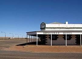 The Birdsville Hotel, adjacent to the apron of Birdsville Airport. | |||||||||||||||
 Birdsville Location in Queensland | |||||||||||||||
| Coordinates | 25°53′56″S 139°21′06″E | ||||||||||||||
| Population | 140 (2016 census)[1] | ||||||||||||||
| Established | 1887 | ||||||||||||||
| Postcode(s) | 4482 | ||||||||||||||
| Elevation | 46.5 m (153 ft) | ||||||||||||||
| Location | |||||||||||||||
| LGA(s) | Shire of Diamantina | ||||||||||||||
| State electorate(s) | Gregory | ||||||||||||||
| Federal Division(s) | Maranoa | ||||||||||||||
| |||||||||||||||
| |||||||||||||||
Birdsville is located on land traditionally owned by the Wongkanguru people, in the Channel Country of Central West Queensland, Australia. It is 1,590 kilometres (990 mi) west of the state capital, Brisbane, and 720 kilometres (450 mi) south of the city of Mount Isa. Birdsville is on the edge of the Simpson Desert, approximately 174 km east of Poeppel Corner and the climate is very arid.
History
Long before Birdsville was established by British colonists, the region in which it is situated was occupied by indigenous Australians, speakers of the Wangkangurru language (also known as Arabana/Wangkangurru, Wangganguru, Wanggangurru or Wongkangurru), whose extent ranged from Birdsville south towards Innamincka and Lake Eyre, including the modern local government areas of the Shire of Diamantina as well as the Outback Communities Authority of South Australia.[4]
Although British explorers had passed through the Diamantina district in the 1840s and early 1860s, pastoralists did not occupy this semi-arid region until the mid-1870s. Annandale, Pandie Pandie, Glengyle and Roseberth were taken up in 1876; Sandringham, Cacoory and Haddon Downs in 1877; and Dubbo Downs in 1878. Monkira, Mt Leonard, Cluny and Coorabulka were other early holdings.[5]
In the early 1880s the towns of Birdsville and Bedourie were established to service the newly taken up pastoral holdings of the Diamantina. Reputedly, a merchant named Matthew Flynn, who carried stores for the stations, built a rough depot in the late 1870s at the site of the present town of Birdsville, then known as the Diamantina Crossing, on the stock route from Boulia south to Adelaide. By mid-1885, when the township of Birdsville was officially surveyed, a number of buildings had been erected at the Diamantina Crossing, including a police lock-up (1883), Groth's Royal Hotel (c. 1883), William Blair's Birdsville Hotel (c. 1883), Curtain's Tattersalls Hotel, and at least 3 stores and 1 shop. Diamantina Shire was established in 1883, and its headquarters were at Birdsville until moved to Bedourie in 1953.[5] Birdsville Post Office opened on 1 January 1883.[6]
Birdsville, over 1,000 miles (1,600 km) west of Brisbane and 7 miles (11 km) north of the Queensland-South Australian border, developed as an administrative centre for police and border customs. Nearly all the trade of the town was with Adelaide, and it became an important marshalling point for cattle being driven south to markets in South Australia. By 1889 the population of Birdsville was 110, and the town had 2 general stores, 3 hotels, a police station, school, 2 blacksmith shops, 2 bakers, a cordial manufacturer, bootmaker, saddler, auctioneer & commission agent, and a number of residences. The population peaked in 1895 at 220.[5]
Birdsville State School opened on 14 August 1899. The school closed in 1948 and has subsequently reopened.[7]
Birdsville is located at the border of South Australia and Queensland to collect tolls from the droves of cattle being moved interstate.
Almost all the buildings in the town were of local sandstone, there being no local timber available. Distance and the lack of good access roads or a railway created prohibitively high transportation costs, so imported building materials were kept to a minimum.[5]
The name
There are a number of different theories as to the origin of the name. One is that the name was suggested by Robert Frew, owner of Pandie Pandie Station, who also had a store and shop at the Diamantina Crossing, in reference to the prolific bird life in the district.[8] The other is that a store was established by Percy Bird and George Field and they called it Birdfield. However, in 1882, G. and R. Wills, of Adelaide, misaddressed a consignment of goods as going to Birdsville and that name stuck.[9] Another is that a man named Burt established a store and called it Burtsville which corrupted to Birdsville.[10] Whatever its origin, by 1882, the name Birdsville was in common use.[11] The name was adopted in the 1885 survey and was formalised at the proclamation of town in 1887.[5]
Population
At the 2016 census, Birdsville had a population of 140. 86.1% of people were born in Australia and 94.2% of people only spoke English at home.[1]
Birdsville had a population of over 300 at the turn of the twentieth century. It had three hotels, a cordial factory, blacksmith store, market gardens, police and customs facilities but after Federation in 1901, the tolls were abolished and the town fell into decline to about 50 people throughout the 1950s. Livestock trade kept the region alive and in recent times tourism has joined cattle as the major industry in the area.[12]
Heritage listings
Birdsville has a number of heritage-listed sites, including:
- Adelaide Street: former Australian Inland Mission Hospital[13]
- Adelaide Street: Birdsville Courthouse[14]
- Adelaide Street: Royal Hotel[15]
- Burt Street: Birdsville Hotel[15]
- Eyre Developmental Road: Carcory Homestead Ruin[16]
- In the north of the locality: Burke and Wills "Plant Camp"[17]
- Glengyle Station, Bedourie: Kidman's Tree of Knowledge[18]
Geography
Birdsville is located by the Diamantina River in the Diamantina Shire, which has a population of 326 persons (Census 2001). The Birdsville Track extends 514 kilometres (319 mi) from Marree in South Australia through the Strzelecki Desert before ending at Birdsville.
Facilities
When it was proclaimed, the town had three hotels, two stores, a customs house for interstate trade, a police station and a large collection of commercial buildings but in 2007 there was just one hotel serving canned or bottled beer, library, visitor information centre, museum and a hospital.[19] Diamantina Shire Council operates Birdsville Library at 29 Burt Street, Birdsville.[20] Today Birdsville is a popular tourist destination with many people using it as a stopping point across the Simpson Desert.
It is also known for the annual Birdsville Races, which are held in September each year in aid of the Royal Flying Doctor Service of Australia. The town's tiny population is augmented by between 7000 and 9000 people for the two-day event, and hundreds of aircraft fill the town's 1,700-metre (1,859 yd) airstrip.[21] In 2010 the races were cancelled for the first time in the event's history due to rain. There are many other events, such as "The Big Red Run" and the "Big Red Bash", held at Birdsville throughout the winter tourist season.
Birdsville also has an 80 kW geothermal power station, the only one of its type in Australia.[22] Water is extracted from an 80-year-old bore on the Great Artesian Basin at 98 °C and is used to heat the operating fluid isopentane in a Rankine Cycle engine. The geothermal plant produces around one third of the town's electricity. The water (once cooled) is also the source of the town's drinking water.[23] A plan by Ergon Energy to expand the 80 kW power plant to completely meet Birdsville's electricity requirements has been shelved, in favour of increasing the use of solar power and battery storage.[24]
Birdsville boasts a state primary school, with a current enrolment of three children, a police station manned by one officer, and a hospital staffed by one nurse.
The town is situated near a billabong on which a pontoon was built to facilitate swimming and non-powered boating activities. In 2012, the billabong became home to a stray freshwater crocodile, which was subsequently removed and relocated by park ranger Don Rowlands OAM.[25][26]
Climate
Birdsville has a hot desert climate (BWh in the Köppen climate classification) with an average of only 22 days of rain a year. Summers are extremely hot and dry, with winters being mild to warm. The median annual rainfall at Birdsville is 133 mm (5.2 in)[27] The actual amount of rain which falls is highly variable, for example, in 1914 just 14 mm (0.55 in) was recorded while 659 mm (25.9 in) fell in 1917. Dust storms are most likely during periods of strong wind which typically occur in spring.[27] Birdsville has recorded the highest confirmed temperature in the state of Queensland, with 49.5 °C (121.1 °F) having been recorded on more than one occasion.
| Climate data for Birdsville Police Station | |||||||||||||
|---|---|---|---|---|---|---|---|---|---|---|---|---|---|
| Month | Jan | Feb | Mar | Apr | May | Jun | Jul | Aug | Sep | Oct | Nov | Dec | Year |
| Record high °C (°F) | 48.5 (119.3) |
47.1 (116.8) |
46.5 (115.7) |
41.7 (107.1) |
37.8 (100.0) |
32.4 (90.3) |
33.4 (92.1) |
36.2 (97.2) |
42.8 (109.0) |
45.1 (113.2) |
48.7 (119.7) |
49.5 (121.1) |
49.5 (121.1) |
| Average high °C (°F) | 38.8 (101.8) |
37.8 (100.0) |
35.1 (95.2) |
30.3 (86.5) |
24.8 (76.6) |
21.6 (70.9) |
20.8 (69.4) |
23.5 (74.3) |
28.1 (82.6) |
32.1 (89.8) |
35.5 (95.9) |
37.7 (99.9) |
30.5 (86.9) |
| Average low °C (°F) | 24.2 (75.6) |
24.1 (75.4) |
21.1 (70.0) |
16.2 (61.2) |
11.3 (52.3) |
7.9 (46.2) |
6.6 (43.9) |
8.3 (46.9) |
12.2 (54.0) |
16.1 (61.0) |
19.7 (67.5) |
22.5 (72.5) |
15.8 (60.4) |
| Record low °C (°F) | 12.2 (54.0) |
13.9 (57.0) |
9.4 (48.9) |
6.0 (42.8) |
1.7 (35.1) |
−1.7 (28.9) |
−1.7 (28.9) |
0.4 (32.7) |
1.5 (34.7) |
2.8 (37.0) |
8.5 (47.3) |
10.9 (51.6) |
−1.7 (28.9) |
| Average precipitation mm (inches) | 24.7 (0.97) |
29.0 (1.14) |
16.4 (0.65) |
9.5 (0.37) |
11.8 (0.46) |
10.4 (0.41) |
10.9 (0.43) |
6.4 (0.25) |
5.7 (0.22) |
12.1 (0.48) |
13.5 (0.53) |
16.0 (0.63) |
167.0 (6.57) |
| Average precipitation days | 2.5 | 2.4 | 1.7 | 1.2 | 1.7 | 1.8 | 1.6 | 1.3 | 1.3 | 2.3 | 2.3 | 2.5 | 22.6 |
| Source: [28] | |||||||||||||
Birdsville disease
Birdsville disease is an illness observed in horses, caused by eating the native plant Birdsville indigo (Indigofera linnaei) which contain natural toxins including the neurotoxin 3 nitropropionic acid (3-NPA). The affected horses exhibit weakness and lack of coordination; it can be fatal. It does not appear to affect cattle.[29] Although it is not unique to Birdsville, the condition was first observed in the Birdsville district in May 1886.[30] While there were many theories about the cause of the disease including plants, worms and sunstroke, it was not until 1950 that researchers identified the precise cause.[31] Mildly affected horses can recover with a regime of drenching with gelatine and feeding a diet high in arginine but euthanasia is recommended for severely affected horses. As there is no cure, preventing horses from grazing on indigo is recommended.[29]
In popular culture
- Elizabeth Haran's 2004 novel Stars in the Southern Sky is set in the town (though renamed to Kangaroo Crossing).
- The 2014 British comedy film The Inbetweeners 2 had scenes set in the town.
- The 1983 novel 'The Film-Makers' by Kenneth and Kerry Cook is partially set in Birdsville.
- Slim Dusty sings a song about the Birdsville Pub (hotel) called Where Country Is
- The 1954 Film The Back of Beyond was about the 300 km mail run to Birdsville.
References
- Australian Bureau of Statistics (27 June 2017). "Birdsville (State Suburb)". 2016 Census QuickStats. Retrieved 18 October 2017.

- "Birdsville - town (entry 47588)". Queensland Place Names. Queensland Government. Retrieved 10 September 2016.
- "Birdsville - locality (entry 41499)". Queensland Place Names. Queensland Government. Retrieved 10 September 2016.
-

- "Birdsville Hotel (entry 600461)". Queensland Heritage Register. Queensland Heritage Council. Retrieved 1 August 2014.
- Premier Postal History. "Post Office List". Premier Postal Auctions. Retrieved 10 May 2014.
- "Opening and closing dates of Queensland Schools". Queensland Government. Retrieved 18 April 2019.
- "Birdsville (entry 47588)". Queensland Place Names. Queensland Government. Retrieved 10 May 2014.
- "NOMENCLATURE OF QUEENSLAND.—42". The Courier-Mail. Brisbane: National Library of Australia. 16 November 1935. p. 12. Retrieved 11 May 2014.
- "OUT WEST IN 80". The Register. Adelaide: National Library of Australia. 15 November 1926. p. 7. Retrieved 11 May 2014.
- "THE FAR NORTH". The Sydney Morning Herald. National Library of Australia. 19 August 1882. p. 9. Retrieved 11 May 2014.
- "History". Birdsville Race Club. 2015. Archived from the original on 1 November 2016. Retrieved 3 November 2016.
- "Australian Inland Mission Hospital (former) (entry 602635)". Queensland Heritage Register. Queensland Heritage Council. Retrieved 7 July 2013.
- "Birdsville Courthouse (entry 600460)". Queensland Heritage Register. Queensland Heritage Council. Retrieved 7 July 2013.
- "Royal Hotel/Australian Inland Mission Hospital (former) (entry 600459)". Queensland Heritage Register. Queensland Heritage Council. Retrieved 1 August 2014.
- "Carcory Homestead Ruin (entry 600458)". Queensland Heritage Register. Queensland Heritage Council. Retrieved 7 July 2013.
- "Burke and Wills "Plant Camp" (entry 645622)". Queensland Heritage Register. Queensland Heritage Council. Retrieved 1 August 2014.
- "Kidman's Tree of Knowledge (entry 600462)". Queensland Heritage Register. Queensland Heritage Council. Retrieved 7 July 2013.
- "Birdsville". Flinders Ranges Research. Archived from the original on 11 January 2007. Retrieved 7 January 2007.
- "Birdsville Library". Public Libraries Connect. State Library of Queensland. Archived from the original on 22 April 2018. Retrieved 23 January 2018.
- "Birdsville Race Club". Birdsville Race Club Inc. Archived from the original on 25 October 2006. Retrieved 7 January 2007.
- "New power station for Birdsville". The North West Star. Fairfax Media. 23 February 2012. Retrieved 11 March 2012.
- "Birdsville geothermal power station (pdf)" (PDF). Queensland Sustainable Energy Innovation Fund. September 2007. Archived from the original (PDF) on 16 July 2006. Retrieved 7 January 2007.
- Vorrath, Sophie (7 June 2018). "Birdsville bids farewell to geothermal, opts for solar and battery storage instead". One Step Off The Grid. Retrieved 16 September 2019.
- Chrissy Arthur & Julia Harris (20 February 2012). "A pontoon for Birdsville's billabong". ABC Western Queensland. Australian Broadcasting Corporation. Archived from the original on 19 November 2014. Retrieved 11 March 2012.
- "Birdsville croc catches sun". ABC Western Queensland. 19 June 2013. Archived from the original on 19 November 2014. Retrieved 30 July 2013.
- Hesse, Paul B. (2010). "The Australian desert dunefields: formation and evolution in an old, flat, dry continent". In Bishop, P.; Pillans, B. (eds.). Australian Landscapes. London: Geological Society. p. 145.
- "BOM".
- "Birdsville Disease" (PDF). Agnote. Northern Territory Government. Archived from the original (PDF) on 19 March 2011. Retrieved 11 May 2014.
- "Agricultural and Pastoral". The Queenslander. National Library of Australia. 8 May 1886. p. 750. Retrieved 11 May 2014.
- "HORSE DISEASE TRACED TO NATIVE PLANT". The Advertiser. Adelaide: National Library of Australia. 26 May 1950. p. 5. Retrieved 11 May 2014.