Big Tujunga Creek
Big Tujunga Creek is a major stream in Los Angeles County in the U.S. state of California. From its headwaters high in the San Gabriel Mountains, it flows generally southwest for 28.8 miles (46.3 km),[4] joining Little Tujunga Creek to form the Tujunga Wash near Pacoima. The stream is sometimes considered as one with the Tujunga Wash, which is the continuation of Big Tujunga to the Los Angeles River, bringing the total length to more than 40 miles (64 km). The name of the stream is derived from a Tongva village name.[5]
| Big Tujunga Creek Tujunga Creek, Tujunga River, Tujunga Wash | |
|---|---|
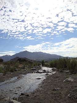 The wash in lower Big Tujunga Canyon | |
| Location | |
| Country | United States |
| State | California |
| Cities | Sunland, Shadow Hills |
| Physical characteristics | |
| Source | About 1.6 miles (2.6 km) south-southeast of Mount Mooney |
| ⁃ location | San Gabriel Mountains |
| ⁃ coordinates | 34°17′52″N 118°00′11″W[1] |
| ⁃ elevation | 5,768 ft (1,758 m) |
| Mouth | Tujunga Wash |
⁃ location | Upstream of Hansen Dam |
⁃ coordinates | 34°16′05″N 118°21′50″W |
⁃ elevation | 1,070 ft (330 m) |
| Length | 22 mi (35 km) |
| Basin size | 130 sq mi (340 km2) |
| Discharge | |
| ⁃ location | near Sunland[2] |
| ⁃ average | 28.1 cu ft/s (0.80 m3/s)[3] |
| ⁃ minimum | 0.29 cu ft/s (0.0082 m3/s) |
| ⁃ maximum | 50,000 cu ft/s (1,400 m3/s) |
| Basin features | |
| Tributaries | |
| ⁃ left | Lucas Creek, Clear Creek |
| ⁃ right | Alder Creek, Mill Creek, Fox Creek, Trail Canyon Creek |
Course
The creek rises near the Angeles Crest Highway in Upper Big Tujunga Canyon, deep within the Angeles National Forest. Its upper course is steep and rocky, and sprinkled with rapids, riffles and small waterfalls. It flows west then northwest, receiving Alder Creek and Lynx Gulch from the right and Wildcat Gulch and Wickiup Creek from the left. As the stream cuts deeper into its gorge, it receives a major tributary, Mill Creek, from the right, and Fall Creek also from the right just before emptying into Big Tujunga Reservoir, formed by the Big Tujunga Dam. While part of the reservoir, it receives Fox Creek from the right.[6]
Below the dam, the stream flows through a steep rocky gorge, receiving Clear Creek from the left, before turning northwest into a broader valley. It flows through this valley for several miles before receiving Trail Canyon Creek from the right, and swinging southwards around a few ridges spills out of the mountains near Sunland. Part of the stream is diverted at Sunland into spreading grounds in order to recharge the local aquifer.[7] The rest of Big Tujunga Creek continues west into the usually dry Hansen Flood Control Basin, formed by the Hansen Dam. Here it receives Little Tujunga Creek also from the right, and becomes the Tujunga Wash, which runs south about 8.5 miles (13.7 km) to the Los Angeles River near Studio City.[6]
River modifications
In 1931, the Big Tujunga Dam was built by the Los Angeles Department of Water and Power deep within the creek's canyon to provide flood control and block silt. With a capacity of just 5,960 acre feet (7,350,000 m3), the dam is unable to control large floods, and has overflowed many times since its construction.[8] During the Los Angeles Flood of 1938, Big Tujunga Creek reached a maximum flow of more than 50,000 cubic feet per second (1,400 m3/s), washing down thousands of tons of silt from the mountains and jumping its banks destroying hundreds of buildings and floodworks. Following the floods, the 97-foot (30 m)-high Hansen Dam was built across the lower creek by the U.S. Army Corps of Engineers in 1940 in the hope of controlling future floods.[9]
See also
References
- "Big Tujunga Creek". Geographic Names Information System. United States Geological Survey. 1991-01-04. Retrieved 2011-02-05.
- "USGS Gage #11095500 on Big Tujunga Creek near Sunland, CA". National Water Information System. U.S. Geological Survey. 1916–1977. Retrieved 2011-02-05.
- "USGS Gage #11095500 on Big Tujunga Creek near Sunland, CA". National Water Information System. U.S. Geological Survey. 1916–1977. Retrieved 2011-02-05.
- U.S. Geological Survey. National Hydrography Dataset high-resolution flowline data. The National Map Archived 2012-04-05 at WebCite, accessed March 16, 2011
- Suntree, Susan (2020). Sacred Sites: The Secret History of Southern California. University of Nebraska Press. p. 273. ISBN 9781496219558.
- USGS Topo Maps for United States (Map). Cartography by United States Geological Survey. ACME Mapper. Retrieved 2011-02-02.
- Stevens, Matt (August 25, 2016). "L.A. betting that stormwater can help ease California's drought". Los Angeles Times. Retrieved 28 August 2016.
- "Big Tujunga Dam". The River Project. Retrieved 2011-02-05.
- Barker, Mayerene (1990-07-20). "Hansen Dam's Comeback Moves Slowly Recreation: Tons of silt have been hauled off, but restoration of the once-popular lake remains years away". Los Angeles Times. Retrieved 2011-02-05.
| Wikimedia Commons has media related to Tujunga Creek. |