Bezirk Cottbus
The Bezirk Cottbus was a district (Bezirk) of East Germany. The administrative seat and the main town was Cottbus.
Bezirk Cottbus | |
|---|---|
District | |
 Coat of arms | |
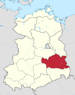 Location of Bezirk Cottbus within the German Democratic Republic | |
| Coordinates: 51°45′N 14°10′E | |
| Country | German Democratic Republic |
| Subdivisions | 14 Kreise and 1 Stadtkreis |
| Formed | 1952 |
| Dissolved | 1990 |
| Seat | Cottbus |
| Area | |
| • Total | 8,262 km2 (3,190 sq mi) |
| Population (1989)[1] | |
| • Total | 884,700 |
| • Density | 110/km2 (280/sq mi) |
| Vehicle registration | Z |
History
The district was established, with the other 13, on July 25, 1952, substituting the old German states. After October 3, 1990, it was disestablished due to the German reunification, becoming again part of the state of Brandenburg. However, districts of Hoyerswerda and Weißwasser went to Saxony and ones of Bad Liebenwerda, Jessen and Herzberg went to Saxony-Anhalt.
Geography
Position
The Bezirk Cottbus, mainly located in Brandenburg and partly in Saxony (Hoyerswerda), bordered with the Bezirke of Frankfurt (Oder), Potsdam, Halle, Leipzig and Dresden. It bordered also with Poland.
Subdivision
The Bezirk was divided into 15 Kreise: 1 urban district (Stadtkreis) and 14 rural districts (Landkreise):
- Urban district : Cottbus.
- Rural districts : Bad Liebenwerda; Calau; Cottbus-Land; Finsterwalde; Forst; Guben; Herzberg; Hoyerswerda; Jessen; Luckau; Lübben; Senftenberg; Spremberg; Weißwasser.
References
- "40 Jahre DDR", National central administration for statistics, May 1989
External links
![]()
| Bezirke (1952–90) | 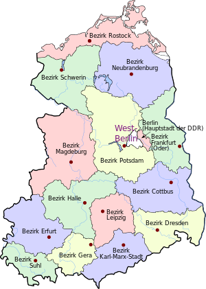 | |
|---|---|---|
| States (1949–52; 1990) | ||
| Authority control |
|
|---|