Bethel Heights, Arkansas
Bethel Heights is a city in Benton County, Arkansas, United States. The population was 2,372 at the 2010 census,[3] up from 714 in 2000 census. It is part of the rapidly growing Northwest Arkansas region.
Bethel Heights, Arkansas | |
|---|---|
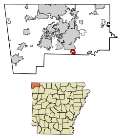 Location of Bethel Heights in Benton County, Arkansas. | |
| Coordinates: 36°13′22″N 94°7′40″W | |
| Country | United States |
| State | Arkansas |
| County | Benton |
| Area | |
| • Total | 2.22 sq mi (5.75 km2) |
| • Land | 2.21 sq mi (5.73 km2) |
| • Water | 0.01 sq mi (0.03 km2) |
| Elevation | 1,348 ft (411 m) |
| Population (2010) | |
| • Total | 2,372 |
| • Estimate (2018)[2] | 2,752 |
| • Density | 1,248.64/sq mi (482.16/km2) |
| Time zone | UTC-6 (Central (CST)) |
| • Summer (DST) | UTC-5 (CDT) |
| FIPS code | 05-05740 |
| GNIS feature ID | 0076320 |
| Website | www |
Geography
Bethel Heights is located in southern Benton County at 36°13′22″N 94°7′40″W (36.222843, -94.127671).[4] It is bordered by Springdale to the east, south, and west, and by Lowell to the north. U.S. Route 71 (Thompson Street) runs north–south along the western side of the city, and Arkansas Highway 264 runs east–west through the center of the city.
According to the United States Census Bureau, the city has a total area of 2.4 square miles (6.2 km2), of which 0.015 square miles (0.04 km2), or 0.69%, is water.[3]
Demographics
| Historical population | |||
|---|---|---|---|
| Census | Pop. | %± | |
| 1970 | 284 | — | |
| 1980 | 296 | 4.2% | |
| 1990 | 281 | −5.1% | |
| 2000 | 714 | 154.1% | |
| 2010 | 2,372 | 232.2% | |
| Est. 2018 | 2,752 | [2] | 16.0% |
| U.S. Decennial Census[5] 2014 Estimate[6] | |||
As of 2010 Bethel Heights had a population of 2,372. The racial and ethnic composition of the population was 49.7% non-Hispanic white, 1.9% black or African American, 1.4% Native American, 3.0% Asian, 8.3% Pacific Islander, 21.6% from some other race, 2.2% from two or more races and 34.7% Hispanic or Latino.[7]
As of the census[8] of 2000, there were 714 people, 251 households, and 211 families residing in the town. The population density was 109.4/km2 (282.8/mi2). There were 261 housing units at an average density of 40.0/km2 (103.4/mi2). The racial makeup of the town was 92.16% White, 1.54% Native American, 2.52% Asian, 1.82% from other races, and 1.96% from two or more races. 3.36% of the population were Hispanic or Latino of any race.
There were 251 households, out of which 42.6% had children under the age of 18 living with them, 78.1% were married couples living together, 3.2% had a female householder with no husband present, and 15.9% were non-families. 13.9% of all households were made up of individuals, and 7.2% had someone living alone who was 65 years of age or older. The average household size was 2.84 and the average family size was 3.10.
In the town the population was spread out, with 28.6% under the age of 18, 5.2% from 18 to 24, 31.0% from 25 to 44, 24.2% from 45 to 64, and 11.1% who were 65 years of age or older. The median age was 35 years. For every 100 females, there were 103.4 males. For every 100 females age 18 and over, there were 103.2 males.
The median income for a household in the town was $48,750, and the median income for a family was $51,172. Males had a median income of $33,438 versus $26,625 for females. The per capita income for the town was $19,001. About 1.9% of families and 4.9% of the population were below the poverty line, including 1.8% of those under age 18 and 11.4% of those age 65 or over.
Education
Bethel Heights is part of the Springdale Public Schools. There are twenty-one schools in the district, including thirteen elementary schools, three middle schools, three junior high schools and two high schools.[9]
Infrastructure
Utilities
The City provides wastewater service via a STEP system, installed in 2003.[10] Bethel Heights has struggled to maintain compliance with Arkansas Department of Health and Arkansas Department of Environmental Quality regulations. The system was out of compliance from August 2013 to January 2017, with sewage surfacing in neighbors' fields, livestock poisonings, multiple violations and fines resulting in a consent administrative order. Violations have continued in 2018 and 2019.[11]
Potable water service is provided by Springdale Water Utilities. Following the sewer system violations, a moratorium on new water system connections was established in June 2019.[12]
American Electric Power (AEP/SWEPCO) and Carroll Electric Cooperative provide electric power in Bethel Heights.[13] Franchise utilities serving the community include AT&T, Black Hills Energy, and Cox Communications.
References
- "2017 U.S. Gazetteer Files". United States Census Bureau. Retrieved Aug 22, 2018.
- "Population and Housing Unit Estimates". Retrieved December 15, 2019.
- "Geographic Identifiers: 2010 Demographic Profile Data (G001): Bethel Heights city, Arkansas". U.S. Census Bureau, American Factfinder. Archived from the original on February 12, 2020. Retrieved September 20, 2013.
- "US Gazetteer files: 2010, 2000, and 1990". United States Census Bureau. 2011-02-12. Retrieved 2011-04-23.
- "Census of Population and Housing". Census.gov. Retrieved June 4, 2015.
- "Annual Estimates of the Resident Population for Incorporated Places: April 1, 2010 to July 1, 2015". Archived from the original on October 19, 2016. Retrieved June 26, 2016.
- 2010 general profile of population and housing characteristics of Bethel Heights from the US census
- "U.S. Census website". United States Census Bureau. Retrieved 2008-01-31.
- "Springdale Public Schools". Springdale Public Schools. Retrieved 2012-06-19.
- Molatore, Tyler (March 2, 2016). "Sewer & Collection Systems: Saving Bethel Heights". Water & Wastes Digest. Scranton Gillette Communication. Retrieved July 23, 2019.
- Joenks, Laurinda (June 23, 2019). "Records show state allowed years of violations in Bethel Heights". Northwest Arkansas Democrat Gazette. WEHCO Media. Retrieved July 23, 2019.
- Joenks, Laurinda (June 5, 2019). "New water service denied to Bethel Heights at state's request". Northwest Arkansas Democrat Gazette. WEHCO Media. Retrieved July 23, 2019.
- Electric Utility Service Territories (polygon) (Map) (Update ed.). Arkansas GIS Office. October 16, 2014 [June 5, 2009]. Retrieved April 7, 2019.
External links
Municipalities and communities of Benton County, Arkansas, United States | ||
|---|---|---|
| Cities | 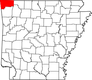 Map of Arkansas highlighting Benton County | |
| Towns | ||
| Townships | ||
| CDPs | ||
| Other communities |
| |
| Ghost towns | ||
| Footnotes | ‡This populated place also has portions in an adjacent county or counties | |