Beth Garmai
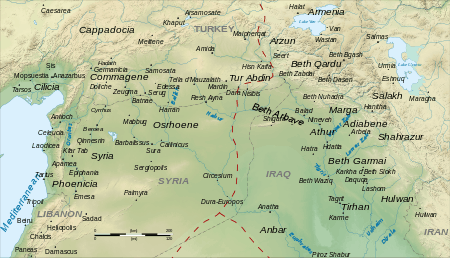
Beth Garmai, (Arabic: باجرمي Bājarmī, Middle Persian: Garamig/Garamīkān/Garmagān, New Persian/Kurdish: Garmakan, Classical Syriac: ܒܝܬ ܓܪܡܐ Bêṯ Garmē,[1] Latin and Greek: Garamaea) is a historical region around the city of Kirkuk in northern Iraq.[2] It is located at southeast of the Little Zab, southwest of the mountains of Shahrazor, northeast of the Tigris and Hamrin Mountains, although sometimes including parts of southwest of Hamrin Mountains, and northwest of the Sirwan River.
Etymology
The name "Beth Garmai" or "Beth Garme" may be of Syriac origin which meaning "the house of bones", which is thought to be a reference to bones of slaughtered Achaemenids after a decisive battle between Alexander the Great and Darius III on the plains between the Upper Zab and Diyala river. However, according to Michael G. Morony, it was named after a people, possibly a Persian tribe.[3]
History
The region was a prosperous metropolitan province centered at Karkha D'Beth Slokh (Kirkuk), It had a substantial Nestorian Assyrian population until the fourteenth century when the region was conquered by Timurlane.[4]
See also
- Beth Garmaï (East Syrian Ecclesiastical Province)
References
- Thomas A. Carlson et al., "Beth Garmai – ܒܝܬ ܓܪ̈ܡܝ ” in The Syriac Gazetteer last modified 14 January 2014, http://syriaca.org/place/33.
- British Institute of Persian Studies (1982). Iran: journal of the British Institute of Persian Studies, Volume 20. 1982: The Institute. p. 14.CS1 maint: location (link)
- Morony 1989, p. 187.
- Wilmshurst, David (2000). The ecclesiastical organisation of the Church of the East, 1318-1913, Volume 582. Peeters Publishers. p. 185. ISBN 978-90-429-0876-5.
Sources
- Wilmshurst, David (2000). The Ecclesiastical Organisation of the Church of the East, 1318–1913. Louvain: Peeters Publishers. ISBN 9789042908765.CS1 maint: ref=harv (link)
- Morony, Michael (1989). "BĒṮ GARMĒ". Encyclopaedia Iranica, Vol. IV, Fasc. 2. p. 187.CS1 maint: ref=harv (link)
Provinces of the Sasanian Empire | ||
|---|---|---|
| ||
* indicates short living provinces | ||