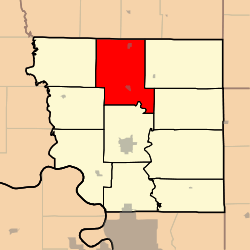
Benton Township, Andrew County, Missouri
Benton Township is one of ten townships in Andrew County, Missouri, United States. As of the 2010 census, its population was 1,020.[3]
Benton Township, Missouri | |
|---|---|
 | |
| Coordinates: 40°04′26″N 094°50′44″W | |
| Country | United States |
| State | Missouri |
| County | Andrew |
| Area | |
| • Total | 49.97 sq mi (129.43 km2) |
| • Land | 49.61 sq mi (128.49 km2) |
| • Water | 0.36 sq mi (0.94 km2) 0.73% |
| Elevation | 935 ft (285 m) |
| Population (2010) | |
| • Total | 1,020 |
| • Density | 20/sq mi (7.9/km2) |
| FIPS code | 29-04564[2] |
| GNIS feature ID | 0766220 |
The township was named after Thomas Hart Benton, a senator from Missouri.[4]
Geography
Benton Township covers an area of 50.0 square miles (129.4 km2) and contains two incorporated settlements: Bolckow and Rosendale.
The streams of Kellog Branch, Lower Neely Branch, Riggin Branch, Upper Neely Branch and White Cloud Creek run through this township.
Transportation
Benton Township contains one airport, Furst Landing Strip.
References
- "US Board on Geographic Names". United States Geological Survey. 2007-10-25. Retrieved 2008-01-31.
- "U.S. Census website". United States Census Bureau. Retrieved 2008-01-31.
- "Geographic Identifiers: 2010 Demographic Profile Data (G001): Benton township, Andrew County, Missouri". U.S. Census Bureau, American Factfinder. Archived from the original on February 12, 2020. Retrieved June 20, 2013.
- "Andrew County Place Names, 1928-1945 (archived)". The State Historical Society of Missouri. Archived from the original on 24 June 2016. Retrieved 30 August 2016.CS1 maint: BOT: original-url status unknown (link)
External links
Municipalities and communities of Andrew County, Missouri, United States | ||
|---|---|---|
| Cities | 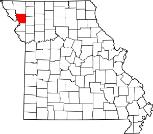 Map of Missouri highlighting Andrew County | |
| Villages | ||
| Townships | ||
| Unincorporated communities | ||
| Ghost towns | ||
This article is issued from Wikipedia. The text is licensed under Creative Commons - Attribution - Sharealike. Additional terms may apply for the media files.