Beni Otsmane
Beni Otsmane, is a village of Tunisia at Latitude36°49'0.01" Longitude10°37'59.99 lies on the Cape Bon peninsula near the village of Sidi Rais and Korbous. Surrounded by the Qorbus Forest, the area has been popular as a health resort since Roman times.[1][2]
Beni Otsmane | |
|---|---|
Commune and town | |
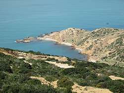 country side near Beni Otsmane | |
| Coordinates: 36°49.0′01″N 10°37′59.99″W | |
| Country | |
| Governorate | Nabeul Governorate |
| Elevation | 348 ft (106 m) |
| Time zone | UTC+1 (CET) |
The name is derived from the Banī ‘Uthmān Tribe that traditionally have lived in the area.[3]
References
- Beni Otsmane: Tunisia, National Geospatial-Intelligence Agency, Bethesda, MD, USA.
- Beni Otsmane Tunisia, North Africa.
- Banī ‘Uthmān, at Geoview.info.
This article is issued from Wikipedia. The text is licensed under Creative Commons - Attribution - Sharealike. Additional terms may apply for the media files.