Cape Bon
| Cape Bon | |
|---|---|
 Cape Bon from space (false color) | |
 Location in Tunisia | |
| Location | Nabeul Governorate, Tunisia |
| Coordinates | 36°45′N 10°45′E |
Cape Bon ("Good Cape") may refer to either
- a peninsula in far northeastern Tunisia, also known as Ras at-Taib (Arabic: الرأس الطيب)[1], Sharīk Peninsula, or Watan el Kibli [2]
- or
- the northernmost point on the peninsula, also known as Ras ed-Dar.
Peninsula
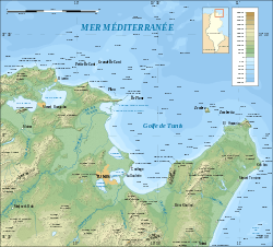
The peninsula's northern shore forms the southern end of the Gulf of Tunis, while its southern shore is on the Gulf of Hammamet.
The peninsula is administered as the country's Nabeul Governorate.
Settlements on the peninsula include Nabeul, El Haouaria, Kelibia, Menzel Temime, Korba, and Beni Khalled. Rivers include the Melah and Chiba wadis. Mountains include Kef Bou Krim (237 m or 778 ft), Kef er-Rend (637 m or 2,090 ft), Djebel Sidi Abd er-Rahmane (602 m or 1,975 ft), Djebel Hofra (421 m or 1,381 ft), and Djebel Reba el-Aine (328 m or 1,076 ft). Besides Cape Bon, other headlands on the peninsula are Ras Dourdas and Ras el-Fortass on the northern shore, Ras el-Melah on the short eastern shore, and Ras Mostefa and Ras Maamoura on the southern shore.
The ruins of the Punic town Kerkouane are also located here. Djebel Mlezza ("Mt Mlessa") has tombs from the time of Agathocles,[3] which were excavated just before the First World War.
See also
- Battles of Cape Bon in 468 and in 1941
- El Brij, Tunisia
- Sidi Rais
- Korbous
References
- - Britannica Concise
- Sharīk Peninsula, Encyclopedia Britannica
- Paul Lachlan MacKendrick, The North African Stones Speak (UNC Press Books, 1 Dec. 2000) p20.