Belarus–Poland border
The Belarusian-Polish border is the state border between the Republic of Poland (EU member) and the Republic of Belarus (Union State) It has a total length of 398.6 km (247.7 mi),[2] 418 km (260 mi)[3] or 416 km (258 mi)[4] (sources vary). It starts from the triple junction of the borders with Lithuania in the north and stretches to the triple junction borders with Ukraine to the south. It is also part of the EU border with Belarus. The border runs along the administrative borders of two Voivodships Podlaskie and Lubelskie in the Polish side and Grodno and Brest Voblasts in the Belarusian side. In the Polish side, the 246.93 km (153.44 mi) section is under the protection of the Podlaskie Border Guard Unit, while the 171.31 km (106.45 mi) section is in the operation area of the Bug River Border Guard Unit. Border rivers (from north to south) are Czarna Hańcza, Wolkuszanka, Swislocz, Narew, and Western Bug.
| Belarusian–Polish border | |
|---|---|
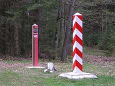 Border crossing in Białowieża Forest | |
| Characteristics | |
| Entities | |
| Length | 398.6 km (248 mi)[1], 418 km (260 mi) or 416 km (258 mi) |
| History | |
| Established | December 1991 Dissolution of the Soviet Union |
| Current shape | 2011 Treaty |


History
After the Soviet invasion of Poland in September 1939, the area of West Belarus was annexed into the Byelorussian Soviet Socialist Republic. Five new Voblasts were created: Baranavichy, Belostok, Brest, Pinsk, and Vialejka.
In accordance with the Border Agreement between Poland and the USSR of 16 August 1945, 17 districts of Belastok Voblast of the BSSR including the city of Białystok and 3 districts of Brest Voblast, where a significant number of Poles lived, were transferred to Poland.
On November 5, 1945, an additional agreement was signed in Warsaw by representatives of the government of the Byelorussian Soviet Socialist Republic and the Government of the National Unity of the Republic of Poland on the registration and evacuation of the Belarusian population from the territory of Poland to the BSRR and Polish population from the BSRR to the territory of Poland. Announcements on registration and extension of the evacuation until June 1946 were posted in Białystok and within the Voivodship.[5]
In 1946, during the refinement of the state border between the USSR and Poland in the Belarusian-Polish section, Krynek, which was entirely granted to Poland, had a point that separated the border section under Sub-Committee V from the activities of Sub-Committee VI. Further, the border ran through areas which Poland lost due to the Soviet dictate, because they were located on the west side of the Curzon Line. This shift was around 12 km in the vicinity of Odelsk, 15 km in the Łosośny area, 20 km in Biała Blota, and 15 km in the area of the Augustów Canal. Polish negotiators during the delimitation procedure realized that they were helpless in the face of these imposed arrangements and were only trying to introduce minor verifications for Poland. Among other things, near Odelsk, within the borders of Poland was the village of the villages of Klimówka, Minkowce, Nomiki, Taki, Tołcze, Szymaki of the Hrodna District and the villages of Todorkowce and Chworosciany of the Sapotskin district were transferred to the Polish People's Republic. Zubrzyca Wielka and Zubrzyca Mała were also recovered, but most of the agricultural lands belonging to these villages remained on Belarusian side of the border.
More to the north, in the area of the village of Nowrowol the border was moved 700-800m to the east, which also allowed the villages of Tołcze, Szymaki and Klimówka to be part of Poland. In the Gmina Kuźnica, the border line was moved 200-300m to the east and at this place the border was cut across the tracks of the Białystok-Grodno railway line.
In August 1948, the TASS agency announced a communication on the completion of delimitation of the border. However, the local authorities determined the final shape of the border and belonging of individual villages or their fragments for more than a year and a half. On the basis of documentation of the Belarusian side, officially announced on July 8, 1950, the Polish side obtained 30 villages as part of exchange and border corrections, while the Belarusian side obtained 12 villages. Also, many villages have been divided. Thereafter, and until now, the border between Poland and Belarus has never changed.
Border crossings
| Title | Type of transition | |
| 1 | Brest - Terespol | Train |
| 2 | Hrodna - Kuźnica Białostocka | Train |
| 3 | Wysokie Litewskie - Czeremcha | Train |
| 4 | Svislach - Siemianówka | Train |
| 5 | Berestovica - Bobrowniki | road |
| 6 | Brest - Terespol | road |
| 7 | Bruzgi - Kuźnica | road |
| 8 | Damachava - Sławatycze | road |
| 9 | Kazlovichy - Kukuryki | road |
| 10 | Piasčatka- Połowce | road |
| 11 | Haurylin - Meykshany | simplified crossing points |
| 12 | Liasnaia - Rudavka | simplified crossing points |
| 13 | Pierarova - Białowieża | simplified crossing points |
References
- Rocznik Statystyczny Rzeczypospolitej Polskiej 2019. Warszawa: Główny Urząd Statystyczny, 2019, s. 80. ISSN 1506-0632.
- "Государственный пограничный комитет Республики Беларусь". Archived from the original on 2016-06-30. Retrieved 2014-05-11.
- "WARUNKI NATURALNE I OCHRONA ŚRODOWISKA (ENVIRONMENT AND ENVIRONMENTAL PROTECTION)". MAŁY ROCZNIK STATYSTYCZNY POLSKI 2013 (CONCISE STATISTICAL YEARBOOK OF POLAND 2013) (in Polish and English). GŁÓWNY URZĄD STATYSTYCZNY. 2013. p. 26. ISSN 1640-3630.
- (in Polish) Informacje o Polsce - informacje ogólne Archived 2009-06-25 at the Wayback Machine. Page gives Polish PWN Encyklopedia as reference.
- Delimitacja polskiej granicy wschodniej 1944-1950
External links
| Wikimedia Commons has media related to Belarus-Poland border. |