Batagaika crater
The Batagaika crater is a thermokarst depression in the Chersky Range area.[1] Administratively it belongs to the Sakha Republic, Russia.
Description
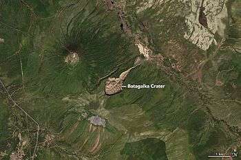
The depression is in the form of a one kilometre-long gash up to 100 metres (328 feet) deep, and growing, in the East Siberian taiga, located 10 km (6.2 mi) southeast of Batagay and 5 km (3.1 mi) northeast of the settlement Ese-Khayya, about 660 km (410 mi) north-northeast of the capital Yakutsk. The structure is named after the near-flowing Batagayka, a right tributary of the river Yana. The land began to sink due to the thawing permafrost in the 1960s after the surrounding forest was cleared.[2] Flooding also contributed to the enlargement of the crater. Archeologists have found ice age fossils buried in the mud around the rim of the crater.[2] The rim is extremely unstable as there are regular landslides into the crater and the permafrost is constantly thawing. The crater is currently growing in size.[2][3]
"Below the cliff face, steep hills and gullies drop to Batagaika's floor. As more of the material at the bottom of the slope melts and comes loose, a larger face is exposed to the air, which in turn increases the speed of permafrost thawing. The crater will likely eat through the entire hillslope before it slows down", Mary Edwards of the University of Southampton said.
"Every year as soon as temperatures go above freezing, it's going to start happening again," she said. "Once you've exposed something like this, it's very hard to stop it".[3]
References
- "200,000 year old soil found at mysterious crater, a 'gate to the subterranean world'". The Siberian Times.
- "Siberia's 'Doorway To The Underworld' Is Rapidly Growing In Size". Forbes. February 28, 2017. Retrieved March 2, 2017.
- Batagaika Crater Expands, NASA Earth Observatory, April 27, 2017
External links
- Batagaika Crater Expands at NASA Earth Observatory, 27 April 2017