Barlow, North Yorkshire
Barlow is a small village and civil parish located in the Selby District of North Yorkshire, England, about 16 miles south of York. In the 2011 census, it had around 290 houses and a population of 753.[1]
| Barlow | |
|---|---|
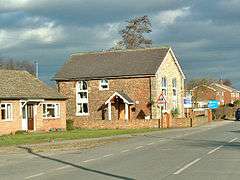 Old Methodist Chapel, Barlow | |
 Barlow Location within North Yorkshire | |
| Population | 753 (2011 census)[1] |
| OS grid reference | SE645285 |
| District | |
| Shire county | |
| Region | |
| Country | England |
| Sovereign state | United Kingdom |
| Post town | SELBY |
| Postcode district | YO8 |
| Dialling code | 01757 |
| Police | North Yorkshire |
| Fire | North Yorkshire |
| Ambulance | Yorkshire |
The village has very few amenities, but there is a primary school and a licensed social club run by a committee of members. There are three entrances to the village, two of which lead from the A1041 road coming out of Selby. The other entrance is a single-track road leading from the Selby bypass. The village's two nature reserves offer a network of paths and bridleways for woodland walks but neither allows horse riding. Barlow common also has a private fishing area and information centre.
Before the 19th century, Barlow was usually known as ‘Berlay’ or ‘Barley’.[2]
Overview
Barlow is an essentially rural village, situated about three miles from the town of Selby and from the motorway network. More recently the village could best be described as a dormitory village for commuters to Selby, York and Leeds. General traffic is light, as Barlow does not lead to anywhere along its main road. At the very end of the village is a roundabout and the Drax Nature Reserve.
The services of the village are quite limited, with only the primary school and social club being the main amenities. Formally the village had a Post Office, Portable Library, and Public House;[3] all of which ceased to operate in the last century. The village has a mixed-use hall near the social club, being prominently used as a daytime nursery and gym.
The village had a community church, which held weekly services and as well as services for the Primary school. It was closed by the parish of Brayton in 2012, due to the very small congregation coming to the weekly services. The vicar however still makes visits to the primary school, to celebrate important events in the Christian calendar.[4]
Barlow has its own bus services for schools and the public. Brayton Academy serves as the nearest secondary school and Selby has the local college. Individual houses continue to be developed in a piecemeal fashion.
History
Evidence of Barlow was first recorded in 1020, in a survey of the estates of the Archbishop of York. After the Norman Conquest, it was part of an estate centred on Drax manor. The only physical evidence of medieval settlement in Barlow is the earthworks around the present Barlow Hall farm.[5] The furrow fields suggest that the area was in use around the time of the Norman Conquest, as the settlement was recorded in the Domesday Book as "Berlai".[6]
In 1520, London gentry family the Thompsons purchased the lands and built the Hall and later village church in the 16th century. The population grew during the industrial period and the main layout of Barlow was erected around this time. Much of the present housing was built in the last century.[6]
The village was the site of an airship production factory in the early part of the 20th century. Established by Whitworth & Co Ltd, it was responsible for the construction of the 25r, R29 and R33 during the First World War. However, in the aftermath of the war, the site became disused and the factory closed being replaced by a munitions depot in 1930. When Drax power station began construction in 1967 the supply depot was discontinued by the Ministry of Defence. The site had been mostly demolished by the late 1970s and all remains of now lie under the ash tip of Barlow Mound.[7]
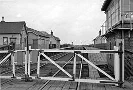
In 1912, the NER established the Selby-Goole railway line which ran through the current nature reserve down to the merry-go-rounds at Drax. It enabled the construction of the airship factory and later the ordnance depot. The station closed to passengers in 1964 but the line was still used by the depot; and for construction on Drax power station until 1983. The line was completely dismantled by 1986 and the nearby ballast tip was replaced by Barlow Common. It was declared a local nature reserve in March 2002.[6]
See also
References
- UK Census (2011). "Local Area Report – Barlow Parish (1170217379)". Nomis. Office for National Statistics. Retrieved 5 October 2018.
- "About Barlow". Barlow Parish Council. Retrieved 10 July 2017.
- Brown Cow Brewery, Barlow (2004). geograph.org.uk. Retrieved 4 February 2020
- "Letter from the Rev Watson" (2012). Barlow Parish Council. Retrieved 4 February 2020
- "Medieval settlement and early post-medieval garden earthworks around Barlow Hall, Barlow - 1018403 | Historic England". Retrieved 26 April 2020.
- "History of Barlow" (PDF). Retrieved 22 August 2018.
- Vikings, airships and ash: the history of Barlow Mound Retrieved 29 October 2018
External links
| Wikimedia Commons has media related to Barlow, North Yorkshire. |