Bardon Park
Bardon Park (also known as Malgamongup) is a park overlooking the Swan River in Maylands, suburb of Perth, Western Australia.[2] It is considered one of Perth's most picturesque parks.[3]
| Bardon Park | |
|---|---|
| |
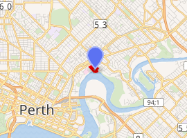
| Location | Maylands, Western Australia |
| Coordinates | 31.93583°S 115.8894°E |
| Elevation | 13 |
| Time zone | AWST (UTC+8) |
| Other information | Geoname: 8151613[1] |
Nearby residents concerned about the park incorporated the Bardon Park Riverside Restoration Group to address weeds in 2016. The park has been managed by the City of Bayswater since 2006.[4]
A nature playground was developed for $175,000 and opened in March 2016. The playground features a rock garden which illustrates "the six Noongar seasons of Birak - the first summer, Bunuru - the second summer, Djeran - autumn, Makuru - the first rains, Djilba - the second rains and Kambarang - flowering."[5] The park is a popular location for Australia Day activities, including watching City of Perth Skyworks.
The Maylands Yacht Club is located on the edge of this park.
The terrain around Bardon Park is flat.[n 1] The highest point nearby is 45 meters above sea level, 1.0 kilometres northwest of Bardon Park.[n 2] Around Bardon Park it is densely populated with 982 inhabitants per square kilometre.[6] The nearest larger society is Perth, 3.2 kilometres southwest of Bardon Park. The area around Bardon Park contains unusually many named bays and beaches.[n 3][1]
Around Bardon Park, it is essentially urban.[7] The climate in the area is 19 . Average yearly in the neighbourhood is 19 °C. The warmest month is January, when the average temperature is 28 °C, And the coldest is June, with 11 °C.[8] Average annual precipitation is 820 millimeter. The rainy month is July, on average142 mm rainfall, and the driest is January, with 11 mm precipitation.[9]
Notes
- Calculated from the variance of all elevation data (DEM 3")From Viewfinder Panoramas, within 10 kilometers radius.
- Provided by highlights (DEM 3") From Viewfinder Panoramas.
- Significantly more within 20 kilometres radius compared to the average incidence of named ones on Earth, according to GeoNames.
Sources
- Bardon Park GeoNames.Org (cc-by)]; post date 2012-01-22; database download 2015-12-01
- "City of Bayswater Parks and Playgrounds".
- Hopping, Carolyn (10 December 2014). "Bardon Park - Maylands". Weekend Notes.
- Toyah Shakespeare (11 October 2016). "Residents to tackle Bardon Park weeds themselves". Eastern Reporter.
- "City of Bayswater". www.facebook.com.
- "NASA Earth Observations: Population Density". NASA/SEDAC. 30 January 2016.
- "NASA Earth Observations: Land Cover Classification". NASA/MODIS. 30 January 2016.
- "NASA Earth Observations Data Set Index". NASA. 30 January 2016. Temperature data from satellite measurements of ground surface temperature within a 0.1 x 0.1 degree box.
- "NASA Earth Observations: Rainfall (1 month – TRMM)". NASA/Tropical Rainfall Monitoring Mission. 30 January 2016. Medelvärde för åren 2012–2014 inom en ruta som är 0,1×0,1 grader.